• 文献检索
  • 文档翻译
  • 深度研究
  • 学术资讯
  • Suppr Zotero 插件Zotero 插件
  • 邀请有礼
  • 套餐&价格
  • 历史记录
应用&插件
Suppr Zotero 插件Zotero 插件浏览器插件Mac 客户端Windows 客户端微信小程序
定价
高级版会员购买积分包购买API积分包
服务
文献检索文档翻译深度研究API 文档MCP 服务
关于我们
关于 Suppr公司介绍联系我们用户协议隐私条款
关注我们

Suppr 超能文献

核心技术专利:CN118964589B侵权必究
粤ICP备2023148730 号-1Suppr @ 2026

文献检索

告别复杂PubMed语法,用中文像聊天一样搜索,搜遍4000万医学文献。AI智能推荐,让科研检索更轻松。

立即免费搜索

文件翻译

保留排版,准确专业,支持PDF/Word/PPT等文件格式,支持 12+语言互译。

免费翻译文档

深度研究

AI帮你快速写综述,25分钟生成高质量综述,智能提取关键信息,辅助科研写作。

立即免费体验

使用地理信息系统(GIS)对登革热风险地区进行多变量时空分析,以识别脆弱地区。

Multivariate spatio-temporal approach to identify vulnerable localities in dengue risk areas using Geographic Information System (GIS).

机构信息

Molecular Medicine Unit, Faculty of Medicine, University of Kelaniya, Ragama, Sri Lanka.

Postgraduate Institute of Science, University of Peradeniya, Peradeniya, Sri Lanka.

出版信息

Sci Rep. 2021 Feb 18;11(1):4080. doi: 10.1038/s41598-021-83204-1.

DOI:10.1038/s41598-021-83204-1
PMID:33602959
原文链接:https://pmc.ncbi.nlm.nih.gov/articles/PMC7892844/
Abstract

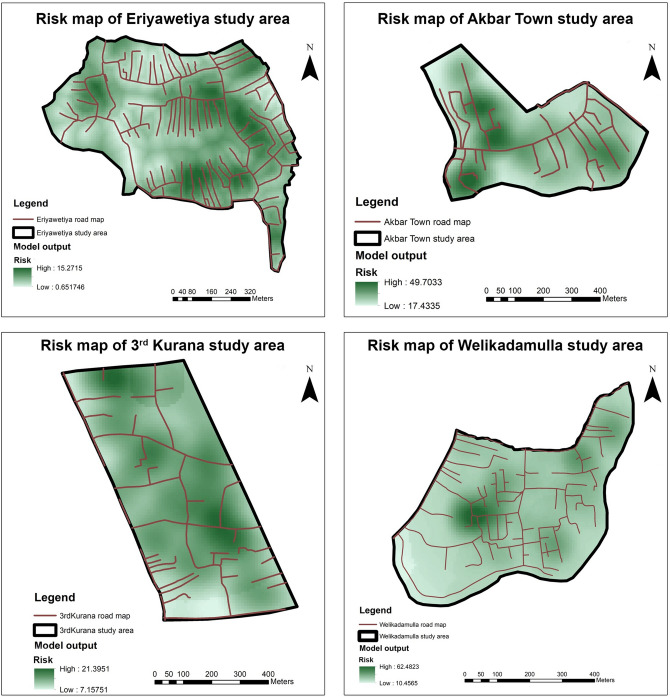
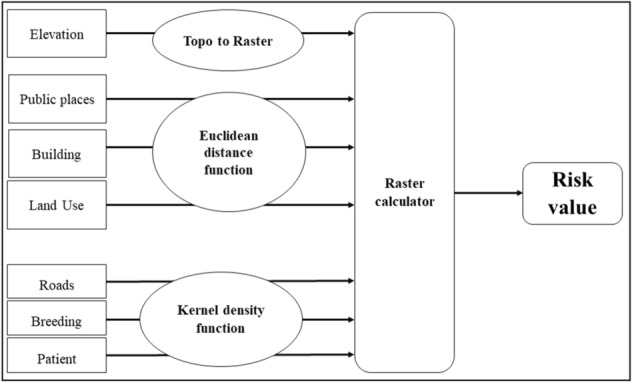
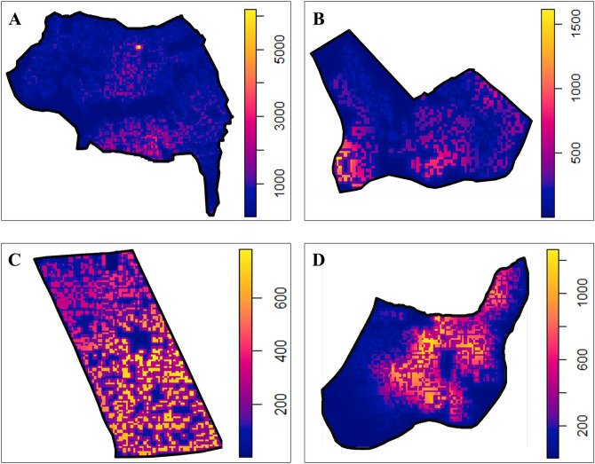
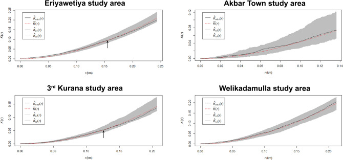
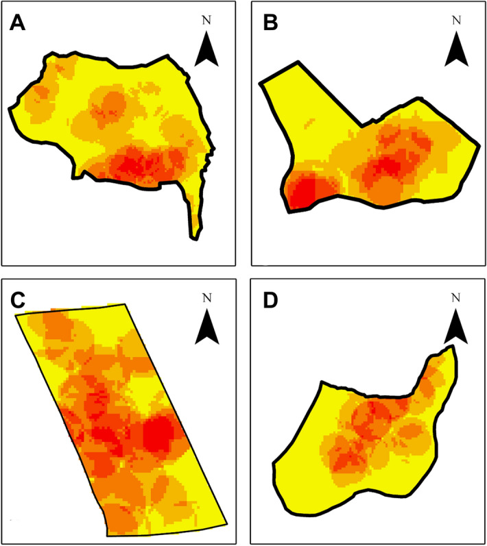
Dengue is one of the most important vector-borne infection in Sri Lanka currently leading to vast economic and social burden. Neither a vaccine nor drug is still not being practiced, vector controlling is the best approach to control disease transmission in the country. Therefore, early warning systems are imminent requirement. The aim of the study was to develop Geographic Information System (GIS)-based multivariate analysis model to detect risk hotspots of dengue in the Gampaha District, Sri Lanka to control diseases transmission. A risk model and spatial Poisson point process model were developed using separate layers for patient incidence locations, positive breeding containers, roads, total buildings, public places, land use maps and elevation in four high risk areas in the district. Spatial correlations of each study layer with patient incidences was identified using Kernel density and Euclidean distance functions with minimum allowed distance parameter. Output files of risk model indicate that high risk localities are in close proximity to roads and coincide with vegetation coverage while the Poisson model highlighted the proximity of high intensity localities to public places and possibility of artificial reservoirs of dengue. The latter model further indicate that clustering of dengue cases in a radius of approximately 150 m in high risk areas indicating areas need intensive attention in future vector surveillances.

摘要

登革热是目前斯里兰卡最重要的虫媒传染病之一,给该国带来了巨大的经济和社会负担。目前既没有疫苗,也没有药物,因此控制病媒是该国控制疾病传播的最佳方法。因此,迫切需要建立早期预警系统。本研究旨在开发基于地理信息系统(GIS)的多元分析模型,以检测斯里兰卡甘帕哈区登革热的风险热点,从而控制疾病传播。在该地区的四个高风险区域中,使用单独的层为患者发病地点、阳性滋生容器、道路、总建筑物、公共场所、土地利用图和海拔,分别开发了风险模型和空间泊松点过程模型。使用核密度和欧几里得距离函数以及最小允许距离参数识别每个研究层与患者发病的空间相关性。风险模型的输出文件表明,高风险地区靠近道路且与植被覆盖度密切相关,而泊松模型则突出了高强度地区与公共场所的接近程度以及登革热人工蓄水池的可能性。后者的模型进一步表明,在高风险地区,登革热病例在半径约 150 m 的范围内呈聚集性,这表明这些区域在未来的病媒监测中需要高度关注。

https://cdn.ncbi.nlm.nih.gov/pmc/blobs/b7a4/7892844/dfc372e87b3e/41598_2021_83204_Fig5_HTML.jpg
https://cdn.ncbi.nlm.nih.gov/pmc/blobs/b7a4/7892844/ca9c0c209798/41598_2021_83204_Fig1_HTML.jpg
https://cdn.ncbi.nlm.nih.gov/pmc/blobs/b7a4/7892844/8f20e5fa59eb/41598_2021_83204_Fig2_HTML.jpg
https://cdn.ncbi.nlm.nih.gov/pmc/blobs/b7a4/7892844/8721ca5ff1ef/41598_2021_83204_Fig3_HTML.jpg
https://cdn.ncbi.nlm.nih.gov/pmc/blobs/b7a4/7892844/e2d3c9f945ee/41598_2021_83204_Fig4_HTML.jpg
https://cdn.ncbi.nlm.nih.gov/pmc/blobs/b7a4/7892844/dfc372e87b3e/41598_2021_83204_Fig5_HTML.jpg

相似文献

1
Multivariate spatio-temporal approach to identify vulnerable localities in dengue risk areas using Geographic Information System (GIS).使用地理信息系统(GIS)对登革热风险地区进行多变量时空分析,以识别脆弱地区。
Sci Rep. 2021 Feb 18;11(1):4080. doi: 10.1038/s41598-021-83204-1.
2
A forecasting model for dengue incidence in the District of Gampaha, Sri Lanka.斯里兰卡加姆珀哈区登革热发病率预测模型。
Parasit Vectors. 2018 Apr 24;11(1):262. doi: 10.1186/s13071-018-2828-2.
3
Entomological surveillance with viral tracking demonstrates a migrated viral strain caused dengue epidemic in July, 2017 in Sri Lanka.昆虫学监测和病毒追踪表明,2017 年 7 月在斯里兰卡发生的登革热疫情是由迁移的病毒株引起的。
PLoS One. 2020 May 6;15(5):e0231408. doi: 10.1371/journal.pone.0231408. eCollection 2020.
4
Use of Novaluron-Based Autocidal Gravid Ovitraps to Control Dengue Vector Mosquitoes in the District of Gampaha, Sri Lanka.基于 Novaluron 的自杀式诱卵器在斯里兰卡甘帕哈区控制登革热病媒蚊子的应用。
Biomed Res Int. 2020 Feb 29;2020:9567019. doi: 10.1155/2020/9567019. eCollection 2020.
5
An information value based analysis of physical and climatic factors affecting dengue fever and dengue haemorrhagic fever incidence.基于信息价值的影响登革热和登革出血热发病率的物理与气候因素分析。
Int J Health Geogr. 2005 Jun 8;4:13. doi: 10.1186/1476-072X-4-13.
6
Bionomic aspects of dengue vectors Aedes aegypti and Aedes albopictus at domestic settings in urban, suburban and rural areas in Gampaha District, Western Province of Sri Lanka.斯里兰卡西部省加姆珀哈地区城市、郊区和农村家庭环境中登革热传播媒介埃及伊蚊和白纹伊蚊的生态学方面。
Parasit Vectors. 2022 Apr 27;15(1):148. doi: 10.1186/s13071-022-05261-3.
7
Spatial-temporal distribution of dengue and climate characteristics for two clusters in Sri Lanka from 2012 to 2016.2012 年至 2016 年斯里兰卡两个集群登革热的时空分布和气候特征。
Sci Rep. 2017 Oct 10;7(1):12884. doi: 10.1038/s41598-017-13163-z.
8
Effect of Climatic Factors and Population Density on the Distribution of Dengue in Sri Lanka: A GIS Based Evaluation for Prediction of Outbreaks.气候因素和人口密度对斯里兰卡登革热分布的影响:基于地理信息系统的疫情预测评估
PLoS One. 2017 Jan 9;12(1):e0166806. doi: 10.1371/journal.pone.0166806. eCollection 2017.
9
Community mobilization and household level waste management for dengue vector control in Gampaha district of Sri Lanka; an intervention study.斯里兰卡甘帕哈地区的登革热病媒控制中的社区动员和家庭层面的废物管理:一项干预研究。
Pathog Glob Health. 2012 Dec;106(8):479-87. doi: 10.1179/2047773212Y.0000000060.
10
Exploratory space-time analysis of reported dengue cases during an outbreak in Florida, Puerto Rico, 1991-1992.1991 - 1992年波多黎各佛罗里达州登革热疫情期间报告登革热病例的探索性时空分析。
Am J Trop Med Hyg. 1998 Mar;58(3):287-98. doi: 10.4269/ajtmh.1998.58.287.

引用本文的文献

1
Modelling the risk of Japanese encephalitis virus in Victoria, Australia, using an expert-systems approach.利用专家系统方法对澳大利亚维多利亚州日本脑炎病毒的风险进行建模。
BMC Infect Dis. 2024 Jan 8;24(1):60. doi: 10.1186/s12879-023-08741-8.
2
Spatial model of Dengue Hemorrhagic Fever (DHF) risk: scoping review.登革出血热(DHF)风险的空间模型:范围综述。
BMC Public Health. 2023 Dec 7;23(1):2448. doi: 10.1186/s12889-023-17185-3.
3
A systematic review of the data, methods and environmental covariates used to map Aedes-borne arbovirus transmission risk.

本文引用的文献

1
The unprecedented magnitude of the 2017 dengue outbreak in Sri Lanka provides lessons for future mosquito-borne infection control and prevention.2017年斯里兰卡登革热疫情的空前规模为未来蚊媒感染的控制和预防提供了经验教训。
Infect Dis Health. 2018 Jun;23(2):114-120. doi: 10.1016/j.idh.2018.02.004. Epub 2018 Mar 7.
2
Modeling the relative role of human mobility, land-use and climate factors on dengue outbreak emergence in Sri Lanka.模拟人类流动性、土地利用和气候因素对斯里兰卡登革热疫情爆发的相对作用。
BMC Infect Dis. 2020 Sep 3;20(1):649. doi: 10.1186/s12879-020-05369-w.
3
Entomological surveillance with viral tracking demonstrates a migrated viral strain caused dengue epidemic in July, 2017 in Sri Lanka.
一项系统回顾数据、方法和环境协变量用于绘制伊蚊传播虫媒病毒风险的地图。
BMC Infect Dis. 2023 Oct 20;23(1):708. doi: 10.1186/s12879-023-08717-8.
4
Multivariate analysis in data science for the geospatial distribution of the breast cancer mortality rate in Colombia.数据科学中关于哥伦比亚乳腺癌死亡率地理空间分布的多变量分析。
Front Oncol. 2023 Jan 6;12:1055655. doi: 10.3389/fonc.2022.1055655. eCollection 2022.
5
Whether Urbanization Has Intensified the Spread of Infectious Diseases-Renewed Question by the COVID-19 Pandemic.城市化是否加剧了传染病的传播——新冠疫情引发的新问题。
Front Public Health. 2021 Nov 24;9:699710. doi: 10.3389/fpubh.2021.699710. eCollection 2021.
昆虫学监测和病毒追踪表明,2017 年 7 月在斯里兰卡发生的登革热疫情是由迁移的病毒株引起的。
PLoS One. 2020 May 6;15(5):e0231408. doi: 10.1371/journal.pone.0231408. eCollection 2020.
4
Use of Novaluron-Based Autocidal Gravid Ovitraps to Control Dengue Vector Mosquitoes in the District of Gampaha, Sri Lanka.基于 Novaluron 的自杀式诱卵器在斯里兰卡甘帕哈区控制登革热病媒蚊子的应用。
Biomed Res Int. 2020 Feb 29;2020:9567019. doi: 10.1155/2020/9567019. eCollection 2020.
5
Comprehensive evaluation of demographic, socio-economic and other associated risk factors affecting the occurrence of dengue incidence among Colombo and Kandy Districts of Sri Lanka: a cross-sectional study.斯里兰卡科伦坡和康堤地区影响登革热发病率的人口统计学、社会经济和其他相关危险因素的综合评估:一项横断面研究。
Parasit Vectors. 2018 Aug 24;11(1):478. doi: 10.1186/s13071-018-3060-9.
6
A forecasting model for dengue incidence in the District of Gampaha, Sri Lanka.斯里兰卡加姆珀哈区登革热发病率预测模型。
Parasit Vectors. 2018 Apr 24;11(1):262. doi: 10.1186/s13071-018-2828-2.
7
DETERMINATION OF ENVIRONMENTAL FACTORS AFFECTING DENGUE INCIDENCE IN SLEMAN DISTRICT, YOGYAKARTA, INDONESIA.印度尼西亚日惹市斯莱曼区影响登革热发病率的环境因素测定
Afr J Infect Dis. 2018 Mar 7;12(1 Suppl):13-25. doi: 10.2101/Ajid.12v1S.3. eCollection 2018.
8
Characterization and productivity profiles of Aedes aegypti (L.) breeding habitats across rural and urban landscapes in western and coastal Kenya.肯尼亚西部和沿海地区城乡景观中埃及伊蚊(L.)繁殖栖息地的特征及生产力概况
Parasit Vectors. 2017 Jul 12;10(1):331. doi: 10.1186/s13071-017-2271-9.
9
Characteristics of and factors associated with dengue vector breeding sites in the City of Colombo, Sri Lanka.斯里兰卡科伦坡市登革热媒介滋生地的特征及相关因素
Pathog Glob Health. 2016 Mar;110(2):79-86. doi: 10.1080/20477724.2016.1175158.
10
Modeling tools for dengue risk mapping - a systematic review.登革热风险地图绘制的建模工具——一项系统综述
Int J Health Geogr. 2014 Dec 9;13:50. doi: 10.1186/1476-072X-13-50.