Department of Animal and Environmental Biology, University of Uyo, Uyo, Akwa Ibom State, Nigeria.
Department of Zoology, Ahmadu Bello University, Zaria, Nigeria.
Sci Rep. 2021 Apr 19;11(1):8490. doi: 10.1038/s41598-021-88020-1.
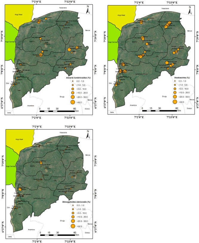
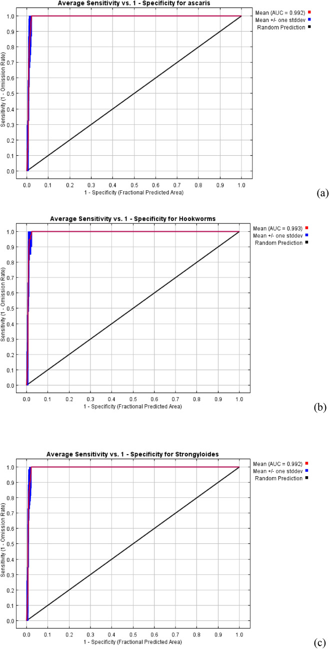
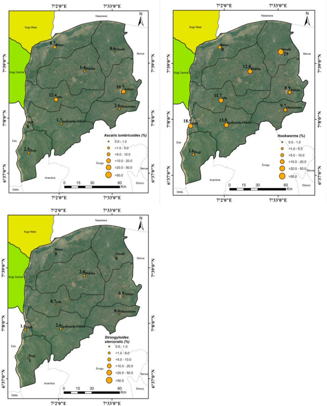
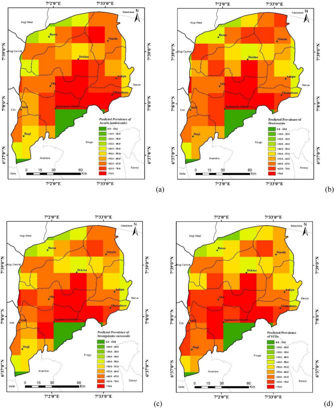
The need for a reliable risk map in the control of soil-transmitted helminths (STHs) in Kogi East, North Central Nigeria is very important. This study was carried out to determine the effect of environmental risk factors on geospatial distribution of STHs. Epidemiological data were obtained from a district-wide survey conducted in 2018 in Kogi East. Edaphic and climatic factors were downloaded as spatial layers from international recognised health data resources centres. A total of 24 environmental factors were used in determining the risk map of STHs using MaxEnt tool. The predicted high-risk areas of A. lumbricoides, hookworms and S. stercoralis were the central part of Kogi East covering parts of Dekina, Ofu, Igalamela-Odolu, Olamaboro and Omala LGAs with probability of 0.8 to 1.00. Among the factors investigated; Temperature [mean diurnal temperature range (BIO2), temperature annual range (BIO7) and maximum temperature of the warmest month (BIO5)], precipitation [precipitation of the wettest quarter (BIO16)], and soil clay contents were the five factors that exerted most significant influence on the geospatial distribution of STHs in Kogi East, Nigeria. Public health control programmes on STHs should target high-risk areas by including them in mass drug administration, health education as well as provision of water, sanitation and hygiene infrastructures.
在尼日利亚中北部科吉东区控制土壤传播性蠕虫(STHs),需要一个可靠的风险图。本研究旨在确定环境风险因素对 STHs 地理空间分布的影响。流行病学数据来自 2018 年在科吉东区进行的全区调查。土壤和气候因素从国际公认的健康数据资源中心作为空间层下载。使用 MaxEnt 工具,共使用了 24 个环境因素来确定 STHs 的风险图。预测的 A. lumbricoides、钩虫和 S. stercoralis 的高风险区域是科吉东区的中心部分,包括 Dekina、Ofu、Igalamela-Odolu、Olamaboro 和 Omala 地方政府区,概率为 0.8 到 1.00。在所调查的因素中;温度[日平均温差(BIO2)、温度年温差(BIO7)和最热月的最高温度(BIO5)]、降水[最湿润季度的降水(BIO16)]和土壤粘含量是对尼日利亚科吉东区 STHs 地理空间分布影响最大的五个因素。针对 STHs 的公共卫生控制计划应通过将高风险地区纳入大规模药物治疗、健康教育以及提供水、卫生和卫生基础设施来针对这些地区。