• 文献检索
  • 文档翻译
  • 深度研究
  • 学术资讯
  • Suppr Zotero 插件Zotero 插件
  • 邀请有礼
  • 套餐&价格
  • 历史记录
应用&插件
Suppr Zotero 插件Zotero 插件浏览器插件Mac 客户端Windows 客户端微信小程序
定价
高级版会员购买积分包购买API积分包
服务
文献检索文档翻译深度研究API 文档MCP 服务
关于我们
关于 Suppr公司介绍联系我们用户协议隐私条款
关注我们

Suppr 超能文献

核心技术专利:CN118964589B侵权必究
粤ICP备2023148730 号-1Suppr @ 2026

文献检索

告别复杂PubMed语法,用中文像聊天一样搜索,搜遍4000万医学文献。AI智能推荐,让科研检索更轻松。

立即免费搜索

文件翻译

保留排版,准确专业,支持PDF/Word/PPT等文件格式,支持 12+语言互译。

免费翻译文档

深度研究

AI帮你快速写综述,25分钟生成高质量综述,智能提取关键信息,辅助科研写作。

立即免费体验

利用无人机图像和深度学习检测稻田产量的田间内差异

Detecting Intra-Field Variation in Rice Yield With Unmanned Aerial Vehicle Imagery and Deep Learning.

作者信息

Bellis Emily S, Hashem Ahmed A, Causey Jason L, Runkle Benjamin R K, Moreno-García Beatriz, Burns Brayden W, Green V Steven, Burcham Timothy N, Reba Michele L, Huang Xiuzhen

机构信息

Department of Computer Science, Arkansas State University, Jonesboro, AR, United States.

Center for No-Boundary Thinking, Arkansas State University, Jonesboro, AR, United States.

出版信息

Front Plant Sci. 2022 Mar 23;13:716506. doi: 10.3389/fpls.2022.716506. eCollection 2022.

DOI:10.3389/fpls.2022.716506
PMID:35401643
原文链接:https://pmc.ncbi.nlm.nih.gov/articles/PMC8984025/
Abstract

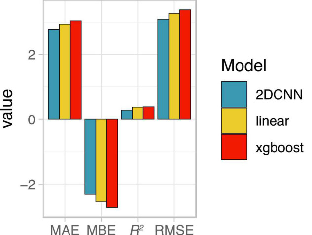
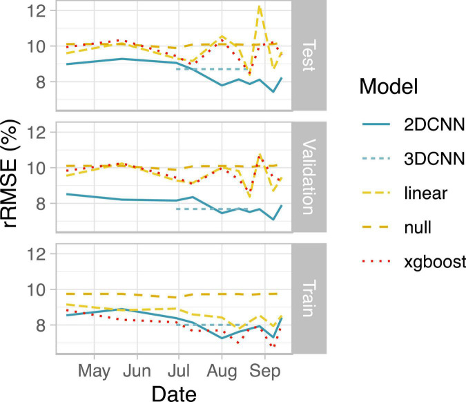
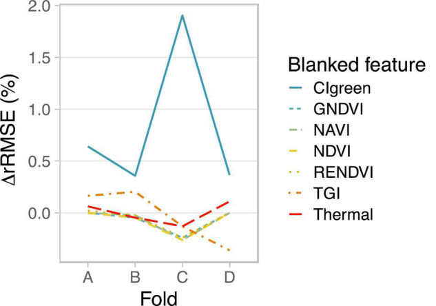
Unmanned aerial vehicles (UAVs) equipped with multispectral sensors offer high spatial and temporal resolution imagery for monitoring crop stress at early stages of development. Analysis of UAV-derived data with advanced machine learning models could improve real-time management in agricultural systems, but guidance for this integration is currently limited. Here we compare two deep learning-based strategies for early warning detection of crop stress, using multitemporal imagery throughout the growing season to predict field-scale yield in irrigated rice in eastern Arkansas. Both deep learning strategies showed improvements upon traditional statistical learning approaches including linear regression and gradient boosted decision trees. First, we explicitly accounted for variation across developmental stages using a 3D convolutional neural network (CNN) architecture that captures both spatial and temporal dimensions of UAV images from multiple time points throughout one growing season. 3D-CNNs achieved low prediction error on the test set, with a Root Mean Squared Error (RMSE) of 8.8% of the mean yield. For the second strategy, a 2D-CNN, we considered only spatial relationships among pixels for image features acquired during a single flyover. 2D-CNNs trained on images from a single day were most accurate when images were taken during booting stage or later, with RMSE ranging from 7.4 to 8.2% of the mean yield. A primary benefit of convolutional autoencoder-like models (based on analyses of prediction maps and feature importance) is the spatial denoising effect that corrects yield predictions for individual pixels based on the values of vegetation index and thermal features for nearby pixels. Our results highlight the promise of convolutional autoencoders for UAV-based yield prediction in rice.

摘要

配备多光谱传感器的无人机可提供高空间和时间分辨率的图像,用于监测作物生长早期阶段的胁迫情况。使用先进的机器学习模型分析无人机获取的数据,可改善农业系统中的实时管理,但目前关于这种整合的指导有限。在此,我们比较了两种基于深度学习的作物胁迫预警检测策略,利用整个生长季节的多时相图像来预测阿肯色州东部灌溉水稻的田间尺度产量。两种深度学习策略均比包括线性回归和梯度提升决策树在内的传统统计学习方法有改进。首先,我们使用一种3D卷积神经网络(CNN)架构明确考虑了不同发育阶段的变化,该架构捕捉了一个生长季节中多个时间点的无人机图像的空间和时间维度。3D-CNN在测试集上实现了低预测误差,均方根误差(RMSE)为平均产量的8.8%。对于第二种策略,即2D-CNN,我们仅考虑了单次飞越期间获取的图像特征中像素之间的空间关系。当在孕穗期或更晚拍摄图像时,基于单日图像训练的2D-CNN最为准确,RMSE范围为平均产量的7.4%至8.2%。卷积自动编码器类模型的一个主要优点(基于预测图和特征重要性分析)是空间去噪效果,它根据附近像素的植被指数和热特征值对单个像素的产量预测进行校正。我们的结果突出了卷积自动编码器在基于无人机的水稻产量预测方面的前景。

https://cdn.ncbi.nlm.nih.gov/pmc/blobs/ad73/8984025/6a17a3d86d66/fpls-13-716506-g006.jpg
https://cdn.ncbi.nlm.nih.gov/pmc/blobs/ad73/8984025/6690006adeb8/fpls-13-716506-g001.jpg
https://cdn.ncbi.nlm.nih.gov/pmc/blobs/ad73/8984025/17b268ce5029/fpls-13-716506-g002.jpg
https://cdn.ncbi.nlm.nih.gov/pmc/blobs/ad73/8984025/d3ed49ea4328/fpls-13-716506-g003.jpg
https://cdn.ncbi.nlm.nih.gov/pmc/blobs/ad73/8984025/8772c9e2972a/fpls-13-716506-g004.jpg
https://cdn.ncbi.nlm.nih.gov/pmc/blobs/ad73/8984025/7a3b753eec1a/fpls-13-716506-g005.jpg
https://cdn.ncbi.nlm.nih.gov/pmc/blobs/ad73/8984025/6a17a3d86d66/fpls-13-716506-g006.jpg

相似文献

1
Detecting Intra-Field Variation in Rice Yield With Unmanned Aerial Vehicle Imagery and Deep Learning.利用无人机图像和深度学习检测稻田产量的田间内差异
Front Plant Sci. 2022 Mar 23;13:716506. doi: 10.3389/fpls.2022.716506. eCollection 2022.
2
In-Season Cotton Yield Prediction with Scale-Aware Convolutional Neural Network Models and Unmanned Aerial Vehicle RGB Imagery.利用尺度感知卷积神经网络模型和无人机RGB图像进行棉花季内产量预测
Sensors (Basel). 2024 Apr 10;24(8):2432. doi: 10.3390/s24082432.
3
UAV Multisensory Data Fusion and Multi-Task Deep Learning for High-Throughput Maize Phenotyping.UAV 多源数据融合与多任务深度学习在高通量玉米表型分析中的应用。
Sensors (Basel). 2023 Feb 6;23(4):1827. doi: 10.3390/s23041827.
4
Entropy Weight Ensemble Framework for Yield Prediction of Winter Wheat Under Different Water Stress Treatments Using Unmanned Aerial Vehicle-Based Multispectral and Thermal Data.基于无人机多光谱和热数据的不同水分胁迫处理下冬小麦产量预测的熵权集成框架
Front Plant Sci. 2021 Dec 20;12:730181. doi: 10.3389/fpls.2021.730181. eCollection 2021.
5
UAV and Machine Learning Based Refinement of a Satellite-Driven Vegetation Index for Precision Agriculture.基于无人机和机器学习的卫星驱动植被指数在精准农业中的改进。
Sensors (Basel). 2020 Apr 29;20(9):2530. doi: 10.3390/s20092530.
6
Multi temporal multispectral UAV remote sensing allows for yield assessment across European wheat varieties already before flowering.多时期多光谱无人机遥感技术能够在开花前对欧洲小麦品种进行产量评估。
Front Plant Sci. 2024 Jan 3;14:1214931. doi: 10.3389/fpls.2023.1214931. eCollection 2023.
7
Machine learning for high-throughput field phenotyping and image processing provides insight into the association of above and below-ground traits in cassava ( Crantz).用于高通量田间表型分析和图像处理的机器学习为木薯(Crantz)地上和地下性状的关联提供了见解。
Plant Methods. 2020 Jun 14;16:87. doi: 10.1186/s13007-020-00625-1. eCollection 2020.
8
Utilizing Spectral, Structural and Textural Features for Estimating Oat Above-Ground Biomass Using UAV-Based Multispectral Data and Machine Learning.利用基于无人机的多光谱数据和机器学习的光谱、结构和纹理特征估算燕麦地上生物量。
Sensors (Basel). 2023 Dec 8;23(24):9708. doi: 10.3390/s23249708.
9
Precision estimation of winter wheat crop height and above-ground biomass using unmanned aerial vehicle imagery and oblique photoghraphy point cloud data.利用无人机影像和倾斜摄影点云数据精确估算冬小麦株高和地上生物量
Front Plant Sci. 2024 Sep 18;15:1437350. doi: 10.3389/fpls.2024.1437350. eCollection 2024.
10
Improving grain yield prediction through fusion of multi-temporal spectral features and agronomic trait parameters derived from UAV imagery.通过融合多时间光谱特征和源自无人机图像的农艺性状参数来改进粮食产量预测。
Front Plant Sci. 2023 Oct 16;14:1217448. doi: 10.3389/fpls.2023.1217448. eCollection 2023.

引用本文的文献

1
Establishing a knowledge structure for yield prediction in cereal crops using unmanned aerial vehicles.利用无人机建立谷物作物产量预测的知识结构。
Front Plant Sci. 2024 Aug 9;15:1401246. doi: 10.3389/fpls.2024.1401246. eCollection 2024.
2
Inversion of winter wheat leaf area index from UAV multispectral images: classical vs. deep learning approaches.基于无人机多光谱图像反演冬小麦叶面积指数:经典方法与深度学习方法对比
Front Plant Sci. 2024 Mar 14;15:1367828. doi: 10.3389/fpls.2024.1367828. eCollection 2024.
3
A review of remote sensing for potato traits characterization in precision agriculture.

本文引用的文献

1
Remote Estimation of Rice Yield With Unmanned Aerial Vehicle (UAV) Data and Spectral Mixture Analysis.利用无人机(UAV)数据和光谱混合分析进行水稻产量的遥感估算。
Front Plant Sci. 2019 Feb 27;10:204. doi: 10.3389/fpls.2019.00204. eCollection 2019.
2
Methane Emission Reductions from the Alternate Wetting and Drying of Rice Fields Detected Using the Eddy Covariance Method.利用涡度相关法检测稻田干湿交替的甲烷减排效果。
Environ Sci Technol. 2019 Jan 15;53(2):671-681. doi: 10.1021/acs.est.8b05535. Epub 2019 Jan 2.
3
Perspectives for Remote Sensing with Unmanned Aerial Vehicles in Precision Agriculture.
精准农业中用于马铃薯性状表征的遥感综述。
Front Plant Sci. 2022 Jul 18;13:871859. doi: 10.3389/fpls.2022.871859. eCollection 2022.
在精准农业中使用无人机进行遥感的展望。
Trends Plant Sci. 2019 Feb;24(2):152-164. doi: 10.1016/j.tplants.2018.11.007. Epub 2018 Dec 15.
4
Active-Optical Sensors Using Red NDVI Compared to Red Edge NDVI for Prediction of Corn Grain Yield in North Dakota, U.S.A.在美国北达科他州,使用红色归一化植被指数(NDVI)与红边NDVI的有源光学传感器用于预测玉米籽粒产量的比较
Sensors (Basel). 2015 Nov 2;15(11):27832-53. doi: 10.3390/s151127832.
5
Distinguishing between yield advances and yield plateaus in historical crop production trends.区分历史作物生产趋势中的产量提高和产量稳定期。
Nat Commun. 2013;4:2918. doi: 10.1038/ncomms3918.
6
Relationships between leaf chlorophyll content and spectral reflectance and algorithms for non-destructive chlorophyll assessment in higher plant leaves.高等植物叶片叶绿素含量与光谱反射率的关系及叶片叶绿素无损评估算法
J Plant Physiol. 2003 Mar;160(3):271-82. doi: 10.1078/0176-1617-00887.
7
Green revolution: the way forward.绿色革命:前进之路。
Nat Rev Genet. 2001 Oct;2(10):815-22. doi: 10.1038/35093585.