Zu Jiaxing, Yang Hailong, Wang Jiali, Cai Wenhua, Yang Yuanzheng
Key Laboratory of Environment Change and Resources Use in Beibu Gulf, Ministry of Education, Nanning Normal University, Nanning, China.
Guangxi Key Laboratory of Earth Surface Processes and Intelligent Simulation, Nanning Normal University, Nanning, China.
Front Plant Sci. 2024 Mar 14;15:1367828. doi: 10.3389/fpls.2024.1367828. eCollection 2024.
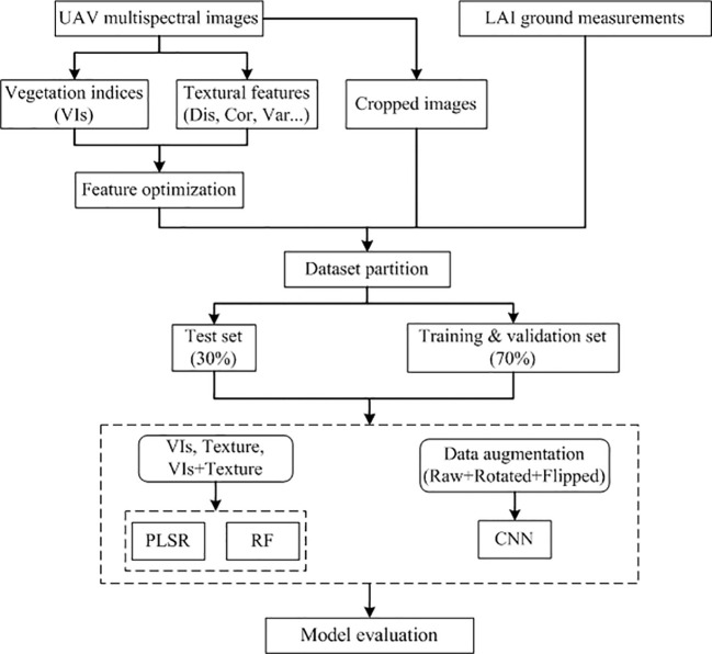
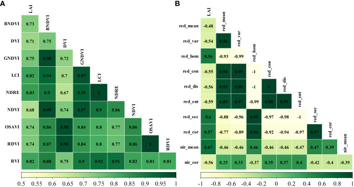
Precise and timely leaf area index (LAI) estimation for winter wheat is crucial for precision agriculture. The emergence of high-resolution unmanned aerial vehicle (UAV) data and machine learning techniques offers a revolutionary approach for fine-scale estimation of wheat LAI at the low cost. While machine learning has proven valuable for LAI estimation, there are still model limitations and variations that impede accurate and efficient LAI inversion. This study explores the potential of classical machine learning models and deep learning model for estimating winter wheat LAI using multispectral images acquired by drones. Initially, the texture features and vegetation indices served as inputs for the partial least squares regression (PLSR) model and random forest (RF) model. Then, the ground-measured LAI data were combined to invert winter wheat LAI. In contrast, this study also employed a convolutional neural network (CNN) model that solely utilizes the cropped original image for LAI estimation. The results show that vegetation indices outperform the texture features in terms of correlation analysis with LAI and estimation accuracy. However, the highest accuracy is achieved by combining both vegetation indices and texture features to invert LAI in both conventional machine learning methods. Among the three models, the CNN approach yielded the highest LAI estimation accuracy ( = 0.83), followed by the RF model ( = 0.82), with the PLSR model exhibited the lowest accuracy ( = 0.78). The spatial distribution and values of the estimated results for the RF and CNN models are similar, whereas the PLSR model differs significantly from the first two models. This study achieves rapid and accurate winter wheat LAI estimation using classical machine learning and deep learning methods. The findings can serve as a reference for real-time wheat growth monitoring and field management practices.
准确及时地估算冬小麦叶面积指数(LAI)对精准农业至关重要。高分辨率无人机(UAV)数据和机器学习技术的出现,为低成本精细尺度估算小麦LAI提供了一种革命性方法。虽然机器学习已被证明对LAI估算很有价值,但仍存在模型局限性和变异性,阻碍了准确高效的LAI反演。本研究探讨了使用无人机获取的多光谱图像,利用经典机器学习模型和深度学习模型估算冬小麦LAI的潜力。首先,纹理特征和植被指数作为偏最小二乘回归(PLSR)模型和随机森林(RF)模型的输入。然后,结合地面实测LAI数据反演冬小麦LAI。相比之下,本研究还采用了一种卷积神经网络(CNN)模型,该模型仅利用裁剪后的原始图像进行LAI估算。结果表明,在与LAI的相关性分析和估算精度方面,植被指数优于纹理特征。然而,在两种传统机器学习方法中,将植被指数和纹理特征结合起来反演LAI可获得最高精度。在这三种模型中,CNN方法的LAI估算精度最高( = 0.83),其次是RF模型( = 0.82),PLSR模型的精度最低( = 0.78)。RF模型和CNN模型估算结果的空间分布和数值相似,而PLSR模型与前两种模型有显著差异。本研究利用经典机器学习和深度学习方法实现了冬小麦LAI的快速准确估算。研究结果可为小麦生长实时监测和田间管理实践提供参考。