Hyun Sangwon, Mishra Aditya, Follett Christopher L, Jonsson Bror, Kulk Gemma, Forget Gael, Racault Marie-Fanny, Jackson Thomas, Dutkiewicz Stephanie, Müller Christian L, Bien Jacob
Data Sciences and Operations, University of Southern California, California, CA, USA.
Center for Computational Mathematics, Flatiron Institute,New York, NY, USA.
Proc Math Phys Eng Sci. 2022 Jun;478(2262):20210875. doi: 10.1098/rspa.2021.0875. Epub 2022 Jun 22.
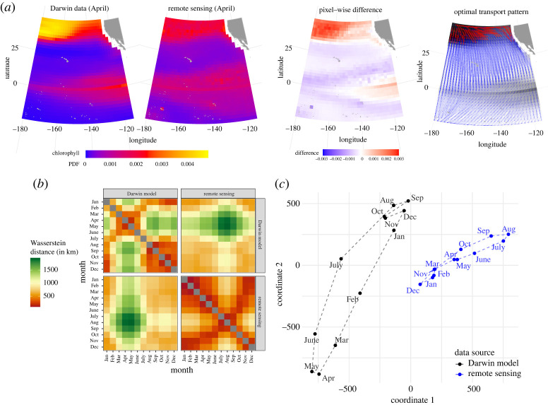
Remote sensing observations from satellites and global biogeochemical models have combined to revolutionize the study of ocean biogeochemical cycling, but comparing the two data streams to each other and across time remains challenging due to the strong spatial-temporal structuring of the ocean. Here, we show that the Wasserstein distance provides a powerful metric for harnessing these structured datasets for better marine ecosystem and climate predictions. The Wasserstein distance complements commonly used point-wise difference methods such as the root-mean-squared error, by quantifying differences in terms of spatial displacement in addition to magnitude. As a test case, we consider chlorophyll (a key indicator of phytoplankton biomass) in the northeast Pacific Ocean, obtained from model simulations, measurements, and satellite observations. We focus on two main applications: (i) comparing model predictions with satellite observations, and (ii) temporal evolution of chlorophyll both seasonally and over longer time frames. The Wasserstein distance successfully isolates temporal and depth variability and quantifies shifts in biogeochemical province boundaries. It also exposes relevant temporal trends in satellite chlorophyll consistent with climate change predictions. Our study shows that optimal transport vectors underlying the Wasserstein distance provide a novel visualization tool for testing models and better understanding temporal dynamics in the ocean.
来自卫星的遥感观测数据与全球生物地球化学模型相结合,彻底改变了海洋生物地球化学循环的研究。然而,由于海洋具有强烈的时空结构,将这两种数据流相互比较以及随时间进行比较仍然具有挑战性。在这里,我们表明,瓦瑟斯坦距离为利用这些结构化数据集以实现更好的海洋生态系统和气候预测提供了一个强大的度量标准。瓦瑟斯坦距离除了通过量化大小差异外,还通过量化空间位移差异来补充常用的逐点差异方法,如均方根误差。作为一个测试案例,我们考虑了从模型模拟、测量和卫星观测中获取的东北太平洋叶绿素(浮游植物生物量的关键指标)。我们专注于两个主要应用:(i)将模型预测与卫星观测进行比较,以及(ii)叶绿素在季节性和更长时间尺度上的时间演变。瓦瑟斯坦距离成功地分离了时间和深度变异性,并量化了生物地球化学省边界的变化。它还揭示了与气候变化预测一致的卫星叶绿素相关时间趋势。我们的研究表明,瓦瑟斯坦距离背后的最优传输向量为测试模型和更好地理解海洋中的时间动态提供了一种新颖的可视化工具。