• 文献检索
  • 文档翻译
  • 深度研究
  • 学术资讯
  • Suppr Zotero 插件Zotero 插件
  • 邀请有礼
  • 套餐&价格
  • 历史记录
应用&插件
Suppr Zotero 插件Zotero 插件浏览器插件Mac 客户端Windows 客户端微信小程序
定价
高级版会员购买积分包购买API积分包
服务
文献检索文档翻译深度研究API 文档MCP 服务
关于我们
关于 Suppr公司介绍联系我们用户协议隐私条款
关注我们

Suppr 超能文献

核心技术专利:CN118964589B侵权必究
粤ICP备2023148730 号-1Suppr @ 2026

文献检索

告别复杂PubMed语法,用中文像聊天一样搜索,搜遍4000万医学文献。AI智能推荐,让科研检索更轻松。

立即免费搜索

文件翻译

保留排版,准确专业,支持PDF/Word/PPT等文件格式,支持 12+语言互译。

免费翻译文档

深度研究

AI帮你快速写综述,25分钟生成高质量综述,智能提取关键信息,辅助科研写作。

立即免费体验

通过半自主四足机器人和六旋翼无人机评估森林生态系统。

Evaluating the Forest Ecosystem through a Semi-Autonomous Quadruped Robot and a Hexacopter UAV.

机构信息

School of Computing and Digital Technology, Birmingham City University, Birmingham B4 7XG, UK.

出版信息

Sensors (Basel). 2022 Jul 23;22(15):5497. doi: 10.3390/s22155497.

DOI:10.3390/s22155497
PMID:35898001
原文链接:https://pmc.ncbi.nlm.nih.gov/articles/PMC9371004/
Abstract

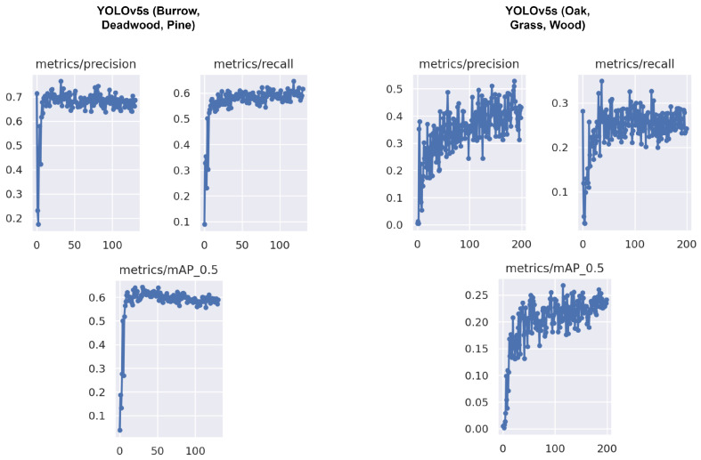
Accurate and timely monitoring is imperative to the resilience of forests for economic growth and climate regulation. In the UK, forest management depends on citizen science to perform tedious and time-consuming data collection tasks. In this study, an unmanned aerial vehicle (UAV) equipped with a light sensor and positioning capabilities is deployed to perform aerial surveying and to observe a series of forest health indicators (FHIs) which are inaccessible from the ground. However, many FHIs such as burrows and deadwood can only be observed from under the tree canopy. Hence, we take the initiative of employing a quadruped robot with an integrated camera as well as an external sensing platform (ESP) equipped with light and infrared cameras, computing, communication and power modules to observe these FHIs from the ground. The forest-monitoring time can be extended by reducing computation and conserving energy. Therefore, we analysed different versions of the YOLO object-detection algorithm in terms of accuracy, deployment and usability by the EXP to accomplish an extensive low-latency detection. In addition, we constructed a series of new datasets to train the YOLOv5x and YOLOv5s for recognising FHIs. Our results reveal that YOLOv5s is lightweight and easy to train for FHI detection while performing close to real-time, cost-effective and autonomous forest monitoring.

摘要

准确、及时的监测对于森林的经济增长和气候调节的恢复力至关重要。在英国,森林管理依赖于公民科学来执行繁琐和耗时的数据收集任务。在这项研究中,一架配备有光传感器和定位能力的无人机 (UAV) 被部署用于进行航空勘测,并观察一系列无法从地面获得的森林健康指标 (FHIs)。然而,许多 FHIs,如洞穴和枯木,只能从树冠下观察到。因此,我们主动采用了一种带有集成摄像头的四足机器人,以及一个带有光和红外摄像头、计算、通信和电源模块的外部感应平台 (ESP),以便从地面观察这些 FHIs。通过减少计算和节约能源,可以延长森林监测时间。因此,我们分析了不同版本的 YOLO 目标检测算法在准确性、部署和 EXP 的可用性方面的表现,以实现广泛的低延迟检测。此外,我们构建了一系列新的数据集来训练 YOLOv5x 和 YOLOv5s 以识别 FHIs。我们的结果表明,YOLOv5s 是轻量级的,易于训练,用于 FHI 检测,同时能够接近实时、经济高效和自主地进行森林监测。

https://cdn.ncbi.nlm.nih.gov/pmc/blobs/9881/9371004/b9f7b9badd0e/sensors-22-05497-g014.jpg
https://cdn.ncbi.nlm.nih.gov/pmc/blobs/9881/9371004/367dfc4b5025/sensors-22-05497-g001.jpg
https://cdn.ncbi.nlm.nih.gov/pmc/blobs/9881/9371004/c1f017c107cb/sensors-22-05497-g002.jpg
https://cdn.ncbi.nlm.nih.gov/pmc/blobs/9881/9371004/87250248d108/sensors-22-05497-g003.jpg
https://cdn.ncbi.nlm.nih.gov/pmc/blobs/9881/9371004/7ff73221e373/sensors-22-05497-g004.jpg
https://cdn.ncbi.nlm.nih.gov/pmc/blobs/9881/9371004/77e9295e6fdc/sensors-22-05497-g005.jpg
https://cdn.ncbi.nlm.nih.gov/pmc/blobs/9881/9371004/0ca0c52e444e/sensors-22-05497-g006.jpg
https://cdn.ncbi.nlm.nih.gov/pmc/blobs/9881/9371004/3b8270d64c88/sensors-22-05497-g007.jpg
https://cdn.ncbi.nlm.nih.gov/pmc/blobs/9881/9371004/d450693fb919/sensors-22-05497-g008.jpg
https://cdn.ncbi.nlm.nih.gov/pmc/blobs/9881/9371004/82a53146bebc/sensors-22-05497-g009.jpg
https://cdn.ncbi.nlm.nih.gov/pmc/blobs/9881/9371004/8483cd4d36e9/sensors-22-05497-g010.jpg
https://cdn.ncbi.nlm.nih.gov/pmc/blobs/9881/9371004/c71aeec8bd5a/sensors-22-05497-g011.jpg
https://cdn.ncbi.nlm.nih.gov/pmc/blobs/9881/9371004/c66c3228e879/sensors-22-05497-g012.jpg
https://cdn.ncbi.nlm.nih.gov/pmc/blobs/9881/9371004/b75273eb5fb2/sensors-22-05497-g013.jpg
https://cdn.ncbi.nlm.nih.gov/pmc/blobs/9881/9371004/b9f7b9badd0e/sensors-22-05497-g014.jpg

相似文献

1
Evaluating the Forest Ecosystem through a Semi-Autonomous Quadruped Robot and a Hexacopter UAV.通过半自主四足机器人和六旋翼无人机评估森林生态系统。
Sensors (Basel). 2022 Jul 23;22(15):5497. doi: 10.3390/s22155497.
2
Locating chimpanzee nests and identifying fruiting trees with an unmanned aerial vehicle.使用无人机定位黑猩猩巢穴并识别结果树。
Am J Primatol. 2015 Oct;77(10):1122-34. doi: 10.1002/ajp.22446. Epub 2015 Jul 14.
3
Early Monitoring of Forest Wood-Boring Pests with Remote Sensing.利用遥感技术对森林蛀干害虫进行早期监测。
Annu Rev Entomol. 2023 Jan 23;68:277-298. doi: 10.1146/annurev-ento-120220-125410. Epub 2022 Oct 5.
4
A framework for precisely thinning planning in a managed pure Chinese fir forest based on UAV remote sensing.基于无人机遥感的精准间伐规划框架在人工纯马尾松林的应用。
Sci Total Environ. 2023 Feb 20;860:160482. doi: 10.1016/j.scitotenv.2022.160482. Epub 2022 Dec 2.
5
Unmanned aerial survey of fallen trees in a deciduous broadleaved forest in eastern Japan.日本东部落叶阔叶林内倒伏树木的无人机空中调查。
PLoS One. 2014 Oct 3;9(10):e109881. doi: 10.1371/journal.pone.0109881. eCollection 2014.
6
Scots pine stands biomass assessment using 3D data from unmanned aerial vehicle imagery in the Chernobyl Exclusion Zone.利用切尔诺贝利隔离区无人机影像的 3D 数据评估苏格兰松立木生物量。
J Environ Manage. 2021 Oct 1;295:113319. doi: 10.1016/j.jenvman.2021.113319. Epub 2021 Jul 22.
7
A modified generative adversarial networks with Yolov5 for automated forest health diagnosis from aerial imagery and Tabu search algorithm.一种基于 Yolov5 的改进生成对抗网络,用于从航空影像中进行自动化森林健康诊断和 Tabu 搜索算法。
Sci Rep. 2024 Feb 27;14(1):4814. doi: 10.1038/s41598-024-54399-w.
8
Classification of riparian forest species and health condition using multi-temporal and hyperspatial imagery from unmanned aerial system.利用无人机系统的多时间和高空间分辨率影像对河岸森林物种和健康状况进行分类
Environ Monit Assess. 2016 Mar;188(3):146. doi: 10.1007/s10661-015-4996-2. Epub 2016 Feb 5.
9
Using canopy height model derived from UAV imagery as an auxiliary for spectral data to estimate the canopy cover of mixed broadleaf forests.利用无人机影像生成的冠层高度模型作为光谱数据的辅助手段,估算混交阔叶林的冠层盖度。
Environ Monit Assess. 2021 Dec 27;194(1):45. doi: 10.1007/s10661-021-09695-7.
10
UAV-Based Digital Terrain Model Generation under Leaf-Off Conditions to Support Teak Plantations Inventories in Tropical Dry Forests. A Case of the Coastal Region of Ecuador.基于无人机的叶落条件下数字地形模型生成,以支持热带干旱森林中的柚木种植园清查。以厄瓜多尔沿海地区为例。
Sensors (Basel). 2019 Apr 25;19(8):1934. doi: 10.3390/s19081934.

引用本文的文献

1
A Review on the State of the Art in Copter Drones and Flight Control Systems.关于直升机无人机与飞行控制系统的技术现状综述。
Sensors (Basel). 2024 May 23;24(11):3349. doi: 10.3390/s24113349.
2
Vision System for a Forestry Navigation Machine.林业导航机的视觉系统。
Sensors (Basel). 2024 Feb 24;24(5):1475. doi: 10.3390/s24051475.
3
SyS3DS: Systematic Sampling of Large-Scale LiDAR Point Clouds for Semantic Segmentation in Forestry Robotics.SyS3DS:用于林业机器人语义分割的大规模激光雷达点云系统采样

本文引用的文献

1
Comparing YOLOv3, YOLOv4 and YOLOv5 for Autonomous Landing Spot Detection in Faulty UAVs.比较 YOLOv3、YOLOv4 和 YOLOv5 在无人机故障自主着陆点检测中的应用。
Sensors (Basel). 2022 Jan 8;22(2):464. doi: 10.3390/s22020464.
2
Autonomous Vision-Based Primary Distribution Systems Porcelain Insulators Inspection Using UAVs.基于自主视觉的无人机对配电网瓷绝缘子进行巡检
Sensors (Basel). 2021 Feb 2;21(3):974. doi: 10.3390/s21030974.
3
Plant Disease Detection by Imaging Sensors - Parallels and Specific Demands for Precision Agriculture and Plant Phenotyping.
Sensors (Basel). 2024 Jan 26;24(3):823. doi: 10.3390/s24030823.
4
Machine learning assisted remote forestry health assessment: a comprehensive state of the art review.机器学习辅助的远程林业健康评估:全面的技术现状综述
Front Plant Sci. 2023 Jun 2;14:1139232. doi: 10.3389/fpls.2023.1139232. eCollection 2023.
5
Using Object Detection Technology to Identify Defects in Clothing for Blind People.利用目标检测技术识别盲人服装缺陷。
Sensors (Basel). 2023 Apr 28;23(9):4381. doi: 10.3390/s23094381.
利用成像传感器进行植物病害检测——精准农业和植物表型分析的相似之处与特殊要求
Plant Dis. 2016 Feb;100(2):241-251. doi: 10.1094/PDIS-03-15-0340-FE. Epub 2016 Jan 18.
4
Challenges for tree officers to enhance the provision of regulating ecosystem services from urban forests.树木管理人员在加强城市森林调节生态系统服务供给方面面临的挑战。
Environ Res. 2017 Jul;156:97-107. doi: 10.1016/j.envres.2017.03.020. Epub 2017 Mar 22.
5
Plant species classification using flower images-A comparative study of local feature representations.基于花卉图像的植物物种分类——局部特征表示的比较研究
PLoS One. 2017 Feb 24;12(2):e0170629. doi: 10.1371/journal.pone.0170629. eCollection 2017.
6
Real-time Medical Emergency Response System: Exploiting IoT and Big Data for Public Health.实时医疗应急响应系统:利用物联网和大数据促进公共卫生
J Med Syst. 2016 Dec;40(12):283. doi: 10.1007/s10916-016-0647-6. Epub 2016 Oct 28.
7
Airborne Optical and Thermal Remote Sensing for Wildfire Detection and Monitoring.用于野火探测与监测的机载光学和热遥感
Sensors (Basel). 2016 Aug 18;16(8):1310. doi: 10.3390/s16081310.
8
Faster R-CNN: Towards Real-Time Object Detection with Region Proposal Networks.更快的 R-CNN:基于区域建议网络的实时目标检测。
IEEE Trans Pattern Anal Mach Intell. 2017 Jun;39(6):1137-1149. doi: 10.1109/TPAMI.2016.2577031. Epub 2016 Jun 6.
9
Classification of riparian forest species and health condition using multi-temporal and hyperspatial imagery from unmanned aerial system.利用无人机系统的多时间和高空间分辨率影像对河岸森林物种和健康状况进行分类
Environ Monit Assess. 2016 Mar;188(3):146. doi: 10.1007/s10661-015-4996-2. Epub 2016 Feb 5.
10
Reducing the dimensionality of data with neural networks.使用神经网络降低数据维度。
Science. 2006 Jul 28;313(5786):504-7. doi: 10.1126/science.1127647.