• 文献检索
  • 文档翻译
  • 深度研究
  • 学术资讯
  • Suppr Zotero 插件Zotero 插件
  • 邀请有礼
  • 套餐&价格
  • 历史记录
应用&插件
Suppr Zotero 插件Zotero 插件浏览器插件Mac 客户端Windows 客户端微信小程序
定价
高级版会员购买积分包购买API积分包
服务
文献检索文档翻译深度研究API 文档MCP 服务
关于我们
关于 Suppr公司介绍联系我们用户协议隐私条款
关注我们

Suppr 超能文献

核心技术专利:CN118964589B侵权必究
粤ICP备2023148730 号-1Suppr @ 2026

文献检索

告别复杂PubMed语法,用中文像聊天一样搜索,搜遍4000万医学文献。AI智能推荐,让科研检索更轻松。

立即免费搜索

文件翻译

保留排版,准确专业,支持PDF/Word/PPT等文件格式,支持 12+语言互译。

免费翻译文档

深度研究

AI帮你快速写综述,25分钟生成高质量综述,智能提取关键信息,辅助科研写作。

立即免费体验

英国零售集聚的开源划分与层次分类。

An open source delineation and hierarchical classification of UK retail agglomerations.

机构信息

University of Sheffield - Department of Urban Studies and Planning, Sheffield, United Kingdom.

Geographic Data Science Lab, University of Liverpool - Department of Geography and Planning, Liverpool, United Kingdom.

出版信息

Sci Data. 2022 Sep 3;9(1):541. doi: 10.1038/s41597-022-01556-3.

DOI:10.1038/s41597-022-01556-3
PMID:36057644
原文链接:https://pmc.ncbi.nlm.nih.gov/articles/PMC9440905/
Abstract

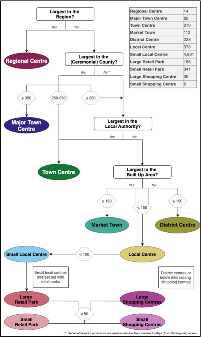
Town centres and high streets typically form the social and commercial cores of UK cities and towns, yet, there is no uniform definition of what a town centre or high street is. In this study the spatial delineations of retail agglomerations are generated using open-source data for England, Wales, Scotland and Northern Ireland. The extent and boundaries of these physical retail areas are identified based on the density and connectivity patterns of individual retail units over space. A high resolution hexagonal grid is superimposed over spatial clusters of retail points and a network-based algorithm used to identify mutually exclusive tracts. Agglomerations are then pruned and fine-tuned according to a series of heuristic rules. Our retail agglomerations represent local commerce areas with shopping amenities and are assigned to a hierarchical classification ranking from the largest Regional Centres, Major Town Centres and Town Centres, down to Small Local Centres and Retail Parks. The classification into one of eleven hierarchies is based on a combination of relative rank in the local area and absolute size of retail units within the area. These retail agglomeration boundaries, hierarchical classification and lookups form an open-source spatial data product available for wide use and research implementation.

摘要

城镇中心和主要商业街通常构成英国城镇的社会和商业核心,但对于什么是城镇中心或主要商业街并没有统一的定义。在这项研究中,使用英格兰、威尔士、苏格兰和北爱尔兰的开源数据生成了零售集聚区的空间划定。这些实体零售区域的范围和边界是根据单个零售单位在空间上的密度和连接模式确定的。在零售点的空间聚类上叠加一个高分辨率的六边形网格,并使用基于网络的算法来识别相互排斥的地段。然后根据一系列启发式规则对集聚体进行修剪和微调。我们的零售集聚区代表具有购物设施的地方商业区域,并根据从最大的区域中心、主要城镇中心和城镇中心到小型地方中心和零售公园的层级分类进行分配。这种分类是基于在当地的相对排名和该地区内零售单位的绝对规模的组合。这些零售集聚区边界、层级分类和查询形成了一个开源的空间数据产品,可供广泛使用和研究实施。

https://cdn.ncbi.nlm.nih.gov/pmc/blobs/0f44/9440905/608357b20c9d/41597_2022_1556_Fig6_HTML.jpg
https://cdn.ncbi.nlm.nih.gov/pmc/blobs/0f44/9440905/3e031b976abd/41597_2022_1556_Fig1_HTML.jpg
https://cdn.ncbi.nlm.nih.gov/pmc/blobs/0f44/9440905/1dd92953d1db/41597_2022_1556_Fig2_HTML.jpg
https://cdn.ncbi.nlm.nih.gov/pmc/blobs/0f44/9440905/69a781a052c4/41597_2022_1556_Fig3_HTML.jpg
https://cdn.ncbi.nlm.nih.gov/pmc/blobs/0f44/9440905/a11d6a807b32/41597_2022_1556_Fig4_HTML.jpg
https://cdn.ncbi.nlm.nih.gov/pmc/blobs/0f44/9440905/ecf9c2e27c0e/41597_2022_1556_Fig5_HTML.jpg
https://cdn.ncbi.nlm.nih.gov/pmc/blobs/0f44/9440905/608357b20c9d/41597_2022_1556_Fig6_HTML.jpg

相似文献

1
An open source delineation and hierarchical classification of UK retail agglomerations.英国零售集聚的开源划分与层次分类。
Sci Data. 2022 Sep 3;9(1):541. doi: 10.1038/s41597-022-01556-3.
2
Understanding Town Centre Performance in Wales: Using GIS to Develop a Tool for Benchmarking.了解威尔士城镇中心的表现:利用地理信息系统开发一个基准测试工具。
Appl Spat Anal Policy. 2022;15(3):713-740. doi: 10.1007/s12061-021-09417-z. Epub 2021 Aug 20.
3
Archetypes of Footfall Context: Quantifying Temporal Variations in Retail Footfall in relation to Micro-Location Characteristics.客流量情境原型:量化与微观位置特征相关的零售客流量的时间变化
Appl Spat Anal Policy. 2022;15(1):161-187. doi: 10.1007/s12061-021-09396-1. Epub 2021 Jul 28.
4
The pattern and mechanism of air pollution in developed coastal areas of China: From the perspective of urban agglomeration.中国发达沿海地区的空气污染模式和机制:从城市群的角度。
PLoS One. 2020 Sep 28;15(9):e0237863. doi: 10.1371/journal.pone.0237863. eCollection 2020.
5
Spatial dynamics of long-term urban retail decline in three transatlantic cities.三个跨大西洋城市长期城市零售业衰退的空间动态
Cities. 2020 Dec;107:102918. doi: 10.1016/j.cities.2020.102918. Epub 2020 Sep 8.
6
A new commercial boundary dataset for metropolitan areas in the USA and Canada, built from open data.一个基于开放数据构建的、适用于美国和加拿大大都市地区的全新商业边界数据集。
Sci Data. 2024 Apr 24;11(1):422. doi: 10.1038/s41597-024-03275-3.
7
When COVID-19 came to town: Measuring the impact of the coronavirus pandemic on footfall on six high streets in England.当新冠疫情来袭:衡量冠状病毒大流行对英格兰六条商业街客流量的影响。
Environ Plan B Urban Anal City Sci. 2022 Mar;49(3):1091-1111. doi: 10.1177/23998083211048497.
8
[Spatial-temporal differentiation and influencing mechanism of green development efficiency in three major urban agglomerations in Zhejiang Province, China.].[中国浙江省三大城市群绿色发展效率的时空分异及影响机制。]
Ying Yong Sheng Tai Xue Bao. 2022 Feb;33(2):509-516. doi: 10.13287/j.1001-9332.202202.014.
9
Access to food retail outlets in County Durham, UK: a pragmatic cross-sectional study.英国达勒姆郡食品零售网点的可达性:一项实用的横断面研究。
Lancet. 2015 Feb 26;385 Suppl 1:S70. doi: 10.1016/S0140-6736(15)60385-3.
10
How safe is it to shop? Estimating the amount of space needed to safely social distance in various retail environments.购物有多安全?估算在各种零售环境中安全保持社交距离所需的空间量。
Saf Sci. 2020 Dec;132:104985. doi: 10.1016/j.ssci.2020.104985. Epub 2020 Sep 15.

引用本文的文献

1
An open retail boundary dataset for South Korea using open data and computer vision technique.一个利用开放数据和计算机视觉技术构建的韩国开放式零售边界数据集。
Sci Data. 2025 Apr 14;12(1):622. doi: 10.1038/s41597-025-04958-1.
2
Mobility of Erasmus+ students in Europe: Geolocated individual and aggregate mobility flows from 2014 to 2022.伊拉斯谟+计划学生在欧洲的流动情况:2014年至2022年按地理位置定位的个人和总体流动趋势
Sci Data. 2025 Mar 24;12(1):489. doi: 10.1038/s41597-025-04789-0.
3
A new commercial boundary dataset for metropolitan areas in the USA and Canada, built from open data.
一个基于开放数据构建的、适用于美国和加拿大大都市地区的全新商业边界数据集。
Sci Data. 2024 Apr 24;11(1):422. doi: 10.1038/s41597-024-03275-3.
4
Using unstable data from mobile phone applications to examine recent trajectories of retail centre recovery.利用来自手机应用程序的不稳定数据来研究零售中心复苏的近期轨迹。
Urban Inform. 2022;1(1):21. doi: 10.1007/s44212-022-00022-0. Epub 2022 Dec 20.