• 文献检索
  • 文档翻译
  • 深度研究
  • 学术资讯
  • Suppr Zotero 插件Zotero 插件
  • 邀请有礼
  • 套餐&价格
  • 历史记录
应用&插件
Suppr Zotero 插件Zotero 插件浏览器插件Mac 客户端Windows 客户端微信小程序
定价
高级版会员购买积分包购买API积分包
服务
文献检索文档翻译深度研究API 文档MCP 服务
关于我们
关于 Suppr公司介绍联系我们用户协议隐私条款
关注我们

Suppr 超能文献

核心技术专利:CN118964589B侵权必究
粤ICP备2023148730 号-1Suppr @ 2026

文献检索

告别复杂PubMed语法,用中文像聊天一样搜索,搜遍4000万医学文献。AI智能推荐,让科研检索更轻松。

立即免费搜索

文件翻译

保留排版,准确专业,支持PDF/Word/PPT等文件格式,支持 12+语言互译。

免费翻译文档

深度研究

AI帮你快速写综述,25分钟生成高质量综述,智能提取关键信息,辅助科研写作。

立即免费体验

利用空间特征框架对英国城市形态和功能进行地理特征描述。

Geographical characterisation of British urban form and function using the spatial signatures framework.

机构信息

Geographic Data Science Lab, Department of Geography and Planning, University of Liverpool, Roxby Building, 74 Bedford St S, Liverpool, L69 7ZT, UK.

The Alan Turing Institute, British Library, 96 Euston Road, London, England, NW1 2DB, UK.

出版信息

Sci Data. 2022 Sep 7;9(1):546. doi: 10.1038/s41597-022-01640-8.

DOI:10.1038/s41597-022-01640-8
PMID:36071072
原文链接:https://pmc.ncbi.nlm.nih.gov/articles/PMC9450829/
Abstract

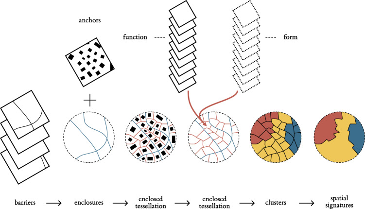
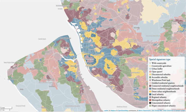
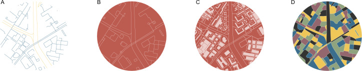
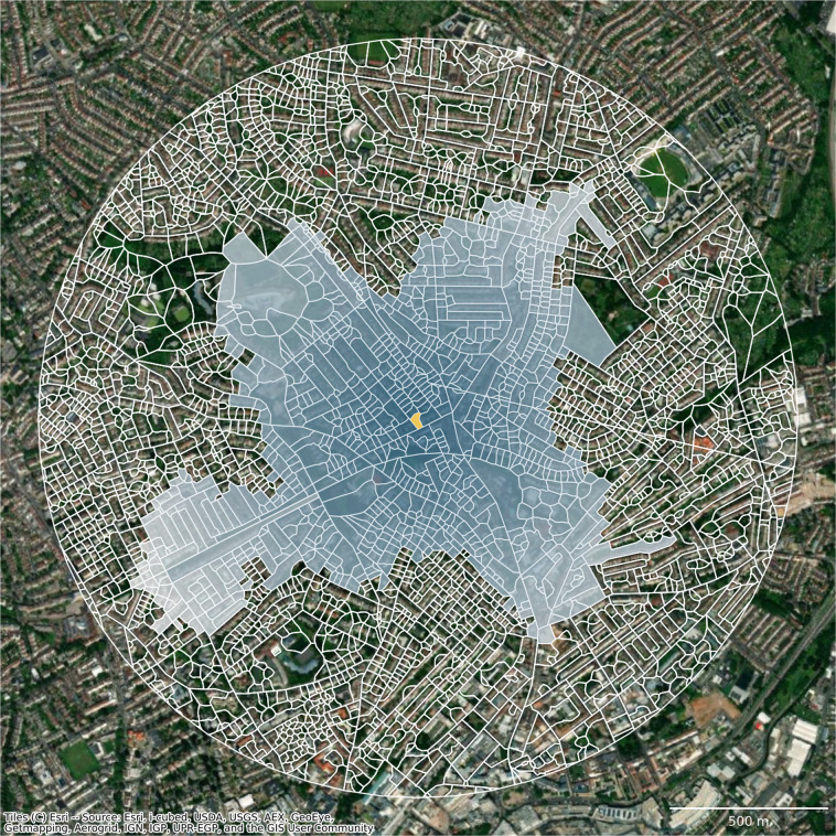
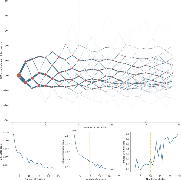
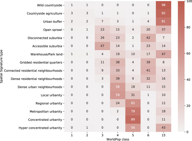
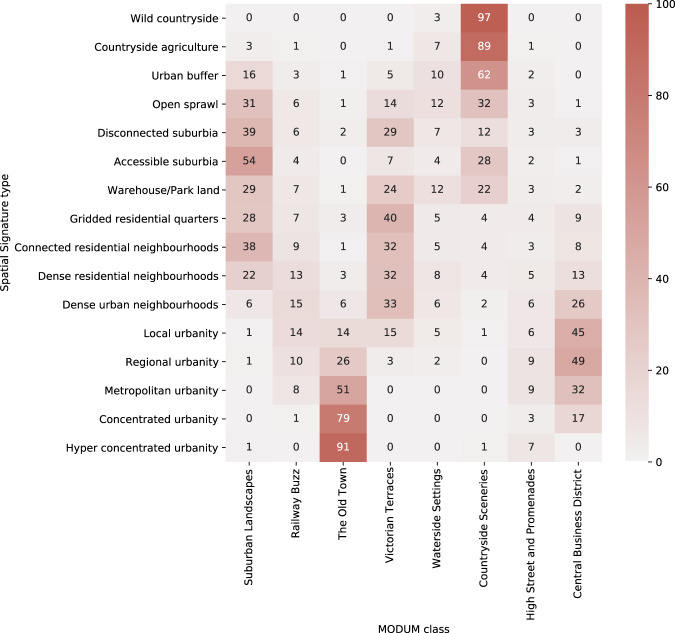
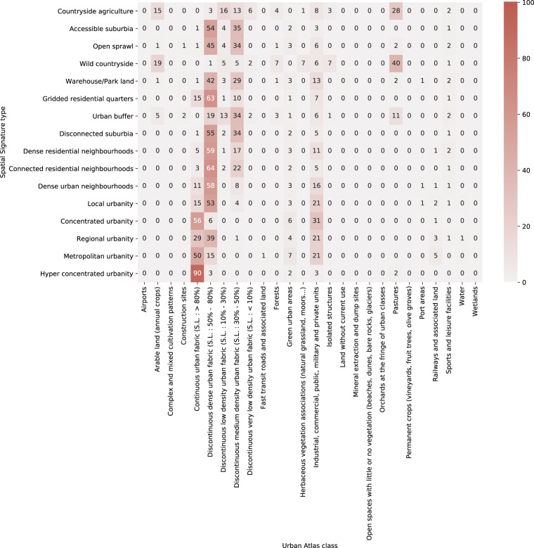
The spatial arrangement of the building blocks that make up cities matters to understand the rules directing their dynamics. Our study outlines the development of the national open-source classification of space according to its form and function into a single typology. We create a bespoke granular spatial unit, the enclosed tessellation, and measure characters capturing its form and function within a relevant spatial context. Using K-Means clustering of individual enclosed tessellation cells, we generate a classification of space for the whole of Great Britain. Contiguous enclosed tessellation cells belonging to the same class are merged forming spatial signature geometries and their typology. We identify 16 distinct types of spatial signatures stretching from wild countryside, through various kinds of suburbia to types denoting urban centres according to their regional importance. The open data product presented here has the potential to serve as boundary delineation for other researchers interested in urban environments and policymakers looking for a unique perspective on cities and their structure.

摘要

城市构成模块的空间布局对于理解指导其动态的规则很重要。我们的研究根据形式和功能将国家开源空间分类法概述为单一类型学。我们创建了一个定制的细粒度空间单元,即封闭镶嵌,并在相关空间背景下测量捕获其形式和功能的特征。使用封闭镶嵌单元的 K-Means 聚类,我们为整个英国生成了一个空间分类。属于同一类的连续封闭镶嵌单元被合并形成空间特征几何形状及其类型。我们确定了 16 种不同类型的空间特征,从野外延伸到各种郊区,再到根据区域重要性表示城市中心的类型。这里提供的开放数据产品有可能成为其他对城市环境感兴趣的研究人员和寻求城市及其结构独特视角的政策制定者的边界划定。

https://cdn.ncbi.nlm.nih.gov/pmc/blobs/814c/9452582/3cbff4823e49/41597_2022_1640_Fig9_HTML.jpg
https://cdn.ncbi.nlm.nih.gov/pmc/blobs/814c/9452582/9d22577b6798/41597_2022_1640_Fig1_HTML.jpg
https://cdn.ncbi.nlm.nih.gov/pmc/blobs/814c/9452582/8824e14cd1a8/41597_2022_1640_Fig2_HTML.jpg
https://cdn.ncbi.nlm.nih.gov/pmc/blobs/814c/9452582/b2bbf6d2ce5f/41597_2022_1640_Fig3_HTML.jpg
https://cdn.ncbi.nlm.nih.gov/pmc/blobs/814c/9452582/fe825fa07e65/41597_2022_1640_Fig4_HTML.jpg
https://cdn.ncbi.nlm.nih.gov/pmc/blobs/814c/9452582/a9caf5684f3b/41597_2022_1640_Fig5_HTML.jpg
https://cdn.ncbi.nlm.nih.gov/pmc/blobs/814c/9452582/db7c096649ea/41597_2022_1640_Fig6_HTML.jpg
https://cdn.ncbi.nlm.nih.gov/pmc/blobs/814c/9452582/7830911b453a/41597_2022_1640_Fig7_HTML.jpg
https://cdn.ncbi.nlm.nih.gov/pmc/blobs/814c/9452582/b578df717c9c/41597_2022_1640_Fig8_HTML.jpg
https://cdn.ncbi.nlm.nih.gov/pmc/blobs/814c/9452582/3cbff4823e49/41597_2022_1640_Fig9_HTML.jpg

相似文献

1
Geographical characterisation of British urban form and function using the spatial signatures framework.利用空间特征框架对英国城市形态和功能进行地理特征描述。
Sci Data. 2022 Sep 7;9(1):546. doi: 10.1038/s41597-022-01640-8.
2
Functional signatures in Great Britain: A dataset.英国的功能特征:一个数据集。
Data Brief. 2022 May 29;43:108335. doi: 10.1016/j.dib.2022.108335. eCollection 2022 Aug.
3
Spatial variations and influencing factors of Cumulative Health Deficit Index of elderly in China.中国老年人累积健康亏损指数的空间差异及影响因素。
J Health Popul Nutr. 2023 Jul 11;42(1):66. doi: 10.1186/s41043-023-00403-4.
4
Macromolecular crowding: chemistry and physics meet biology (Ascona, Switzerland, 10-14 June 2012).大分子拥挤现象:化学与物理邂逅生物学(瑞士阿斯科纳,2012年6月10日至14日)
Phys Biol. 2013 Aug;10(4):040301. doi: 10.1088/1478-3975/10/4/040301. Epub 2013 Aug 2.
5
Research on Spatial Delineation Method of Urban-Rural Fringe Combining POI and Nighttime Light Data-Taking Wuhan City as an Example.基于 POI 与夜间灯光数据的城乡边缘空间界定方法研究——以武汉市为例。
Int J Environ Res Public Health. 2023 Mar 1;20(5):4395. doi: 10.3390/ijerph20054395.
6
Author Correction: Geographical characterisation of British urban form and function using the spatial signatures framework.作者更正:使用空间特征框架对英国城市形态和功能进行地理特征描述。
Sci Data. 2023 Dec 1;10(1):846. doi: 10.1038/s41597-023-02773-0.
7
An open source delineation and hierarchical classification of UK retail agglomerations.英国零售集聚的开源划分与层次分类。
Sci Data. 2022 Sep 3;9(1):541. doi: 10.1038/s41597-022-01556-3.
8
Urban form datasets of 194 cities delineated based on the contiguous urban fabric for 1990 and 2015.基于1990年和2015年连续城市建成区划定的194个城市的城市形态数据集。
Data Brief. 2020 Oct 6;33:106369. doi: 10.1016/j.dib.2020.106369. eCollection 2020 Dec.
9
Urban form and its impacts on air pollution and access to green space: A global analysis of 462 cities.城市形态及其对空气污染和绿地可达性的影响:对 462 个城市的全球分析。
PLoS One. 2023 Jan 25;18(1):e0278265. doi: 10.1371/journal.pone.0278265. eCollection 2023.
10
Research on the relationship between Urban economic development level and urban spatial structure-A case study of two Chinese cities.城市经济发展水平与城市空间结构关系研究——以中国两个城市为例。
PLoS One. 2020 Jul 9;15(7):e0235858. doi: 10.1371/journal.pone.0235858. eCollection 2020.

引用本文的文献

1
Combining Spatial, Genetic, and Environmental Risk Data to Define and Prioritize In Situ Conservation Units.结合空间、遗传和环境风险数据来定义原地保护单元并确定其优先级。
Ecol Evol. 2025 May 26;15(5):e71251. doi: 10.1002/ece3.71251. eCollection 2025 May.
2
Inferring building height from footprint morphology data.从占地面积形态数据推断建筑物高度。
Sci Rep. 2024 Aug 12;14(1):18651. doi: 10.1038/s41598-024-66467-2.
3
ecolo-zip: A global, rich and granular characterization of biogeophysical ecology for 1.5 million postal codes.

本文引用的文献

1
Open data products-A framework for creating valuable analysis ready data.开放数据产品——创建有价值的可供分析的数据的框架。
J Geogr Syst. 2021;23(4):497-514. doi: 10.1007/s10109-021-00363-5. Epub 2021 Oct 20.
2
Tools for mapping multi-scale settlement patterns of building footprints: An introduction to the R package foot.用于绘制建筑足迹多尺度分布格局的工具:R 包 foot 简介
PLoS One. 2021 Feb 25;16(2):e0247535. doi: 10.1371/journal.pone.0247535. eCollection 2021.
3
Mapping Europe into local climate zones.将欧洲映射到当地气候区。
ecolo-zip:为 150 万个邮政编码提供全球、丰富和精细的生物物理生态学特征描述。
Sci Data. 2023 Sep 29;10(1):665. doi: 10.1038/s41597-023-02579-0.
4
Evaluating Spatial Identity Based on Climate Adaptation in Small Cities.基于气候适应性的小城市空间特征评价。
Int J Environ Res Public Health. 2022 Dec 30;20(1):713. doi: 10.3390/ijerph20010713.
5
Functional signatures in Great Britain: A dataset.英国的功能特征:一个数据集。
Data Brief. 2022 May 29;43:108335. doi: 10.1016/j.dib.2022.108335. eCollection 2022 Aug.
PLoS One. 2019 Apr 24;14(4):e0214474. doi: 10.1371/journal.pone.0214474. eCollection 2019.
4
A cluster separation measure.一种聚类分离度量。
IEEE Trans Pattern Anal Mach Intell. 1979 Feb;1(2):224-7.