Remote Sensing and Geoinformatics Section, Helmholtz Centre Potsdam GFZ German Research Centre for Geosciences, Potsdam, Germany.
Institute of Geodesy, University of Stuttgart, Stuttgart, Germany.
Sci Rep. 2022 Dec 1;12(1):20784. doi: 10.1038/s41598-022-24712-6.
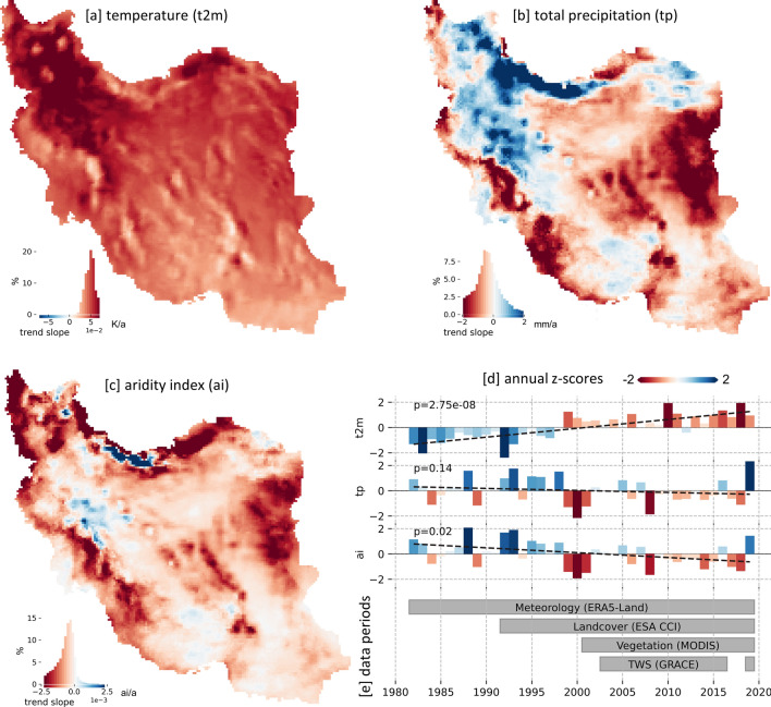
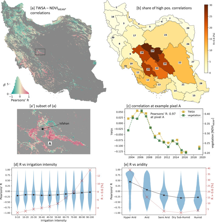
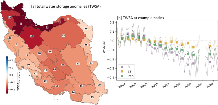
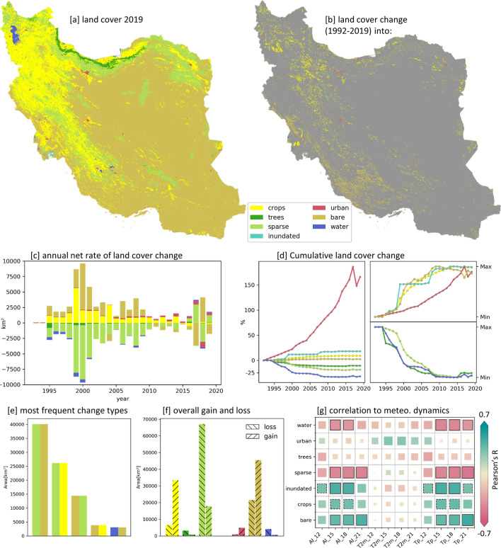
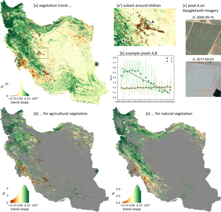
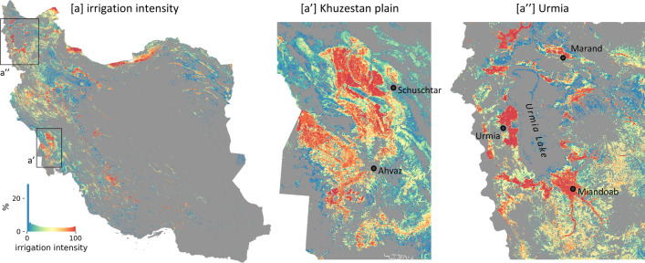
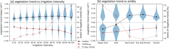
Iran has experienced a drastic increase in water scarcity in the last decades. The main driver has been the substantial unsustainable water consumption of the agricultural sector. This study quantifies the spatiotemporal dynamics of Iran's hydrometeorological water availability, land cover, and vegetation growth and evaluates their interrelations with a special focus on agricultural vegetation developments. It analyzes globally available reanalysis climate data and satellite time series data and products, allowing a country-wide investigation of recent 20+ years at detailed spatial and temporal scales. The results reveal a wide-spread agricultural expansion (27,000 km[Formula: see text]) and a significant cultivation intensification (48,000 km[Formula: see text]). At the same time, we observe a substantial decline in total water storage that is not represented by a decrease of meteorological water input, confirming an unsustainable use of groundwater mainly for agricultural irrigation. As consequence of water scarcity, we identify agricultural areas with a loss or reduction of vegetation growth (10,000 km[Formula: see text]), especially in irrigated agricultural areas under (hyper-)arid conditions. In Iran's natural biomes, the results show declining trends in vegetation growth and land cover degradation from sparse vegetation to barren land in 40,000 km[Formula: see text], mainly along the western plains and foothills of the Zagros Mountains, and at the same time wide-spread greening trends, particularly in regions of higher altitudes. Overall, the findings provide detailed insights in vegetation-related causes and consequences of Iran's anthropogenic drought and can support sustainable management plans for Iran or other semi-arid regions worldwide, often facing similar conditions.
伊朗在过去几十年中经历了水资源严重短缺。主要原因是农业部门大量不可持续的用水。本研究量化了伊朗水文气象水资源、土地覆盖和植被生长的时空动态,并评估了它们之间的相互关系,特别关注农业植被的发展。它分析了全球可用的再分析气候数据和卫星时间序列数据和产品,允许在详细的时空尺度上对最近 20 多年进行全国范围的调查。研究结果显示,伊朗广泛的农业扩张(27000 平方公里)和显著的种植集约化(48000 平方公里)。与此同时,我们观察到总储水量的大量减少,而这并不是气象水资源输入减少造成的,这证实了地下水的大量不可持续利用主要用于农业灌溉。由于水资源短缺,我们确定了农业地区的植被生长减少或减少(10000 平方公里),特别是在(超)干旱条件下的灌溉农业区。在伊朗的自然生物群落中,研究结果显示,植被生长和土地覆盖退化的趋势在 40000 平方公里范围内从稀疏植被到荒地,主要沿着西部平原和扎格罗斯山脉的山麓,同时广泛的绿化趋势,特别是在海拔较高的地区。总的来说,这些发现提供了有关伊朗人为干旱的植被相关原因和后果的详细信息,并可以为伊朗或世界其他半干旱地区的可持续管理计划提供支持,这些地区经常面临类似的情况。