Department of Urban and rural planning, School of Architecture and Design, China University of Mining and technology, Xuzhou 221116, China.
Department of Architecture, School of Architecture and Design, China University of Mining and technology, Xuzhou 221116, China.
Int J Environ Res Public Health. 2023 Jan 24;20(3):2127. doi: 10.3390/ijerph20032127.
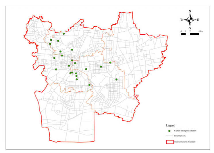
An urban emergency shelter provides a place of temporary life and shelter for victims after a disaster. As a very important public service facility, its spatial layout is greatly related to the security of lives and the property of the urban residents. Upholding the concept of sustainable disaster reduction, this study took the central urban area of Xuzhou as an example. Based on the analysis of ArcGIS software, this study analyzed and planned the spatial layout of emergency shelters in Xuzhou and visualized the service area ratio, service population ratio, service capacity ratio, and service overlap rate of each administrative district. Finally, 73 fixed emergency shelters were determined, among which eight were classified as central shelters. At the same time, through consulting the relevant data, it was found that similar problems such as potential safety hazard, blind areas, service overlapping, and mismatch of shelter layout and actual needs also exist in other cities. Finally, in light of the existing problems, relevant suggestions are provided for the adjustment and optimization of the layout of emergency shelters.
城市应急避难所为灾害后灾民提供临时生活和避难场所。作为一项非常重要的公共服务设施,其空间布局与城市居民的生命安全和财产安全密切相关。本研究秉持可持续减灾理念,以徐州市中心城区为例,基于 ArcGIS 软件分析,对徐州市应急避难所的空间布局进行分析规划,并可视化各行政区的服务面积比、服务人口比、服务容量比和服务重叠率。最终确定了 73 个固定应急避难所,其中 8 个被归类为中心避难所。同时,通过查阅相关数据,发现其他城市也存在类似的潜在安全隐患、盲区、服务重叠、避难所布局与实际需求不匹配等问题。最后,针对存在的问题,对应急避难所布局的调整和优化提出了相关建议。