• 文献检索
  • 文档翻译
  • 深度研究
  • 学术资讯
  • Suppr Zotero 插件Zotero 插件
  • 邀请有礼
  • 套餐&价格
  • 历史记录
应用&插件
Suppr Zotero 插件Zotero 插件浏览器插件Mac 客户端Windows 客户端微信小程序
定价
高级版会员购买积分包购买API积分包
服务
文献检索文档翻译深度研究API 文档MCP 服务
关于我们
关于 Suppr公司介绍联系我们用户协议隐私条款
关注我们

Suppr 超能文献

核心技术专利:CN118964589B侵权必究
粤ICP备2023148730 号-1Suppr @ 2026

文献检索

告别复杂PubMed语法,用中文像聊天一样搜索,搜遍4000万医学文献。AI智能推荐,让科研检索更轻松。

立即免费搜索

文件翻译

保留排版,准确专业,支持PDF/Word/PPT等文件格式,支持 12+语言互译。

免费翻译文档

深度研究

AI帮你快速写综述,25分钟生成高质量综述,智能提取关键信息,辅助科研写作。

立即免费体验

卫星揭示全球河流延伸变化的热点。

Satellites reveal hotspots of global river extent change.

机构信息

Key Laboratory of Watershed Geographic Sciences, Nanjing Institute of Geography and Limnology, Chinese Academy of Sciences, Nanjing, 210008, China.

School of Biological Sciences and Institute for Climate and Carbon Neurality, The University of Hong Kong, Pokfulam Road, Hong Kong, China.

出版信息

Nat Commun. 2023 Mar 22;14(1):1587. doi: 10.1038/s41467-023-37061-3.

DOI:10.1038/s41467-023-37061-3
PMID:36949069
原文链接:https://pmc.ncbi.nlm.nih.gov/articles/PMC10033638/
Abstract

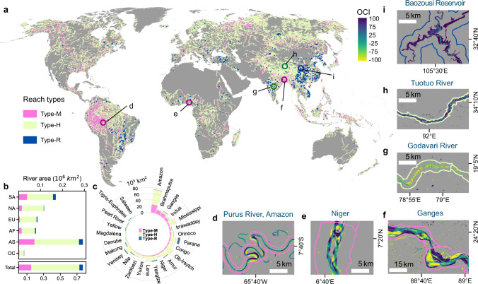
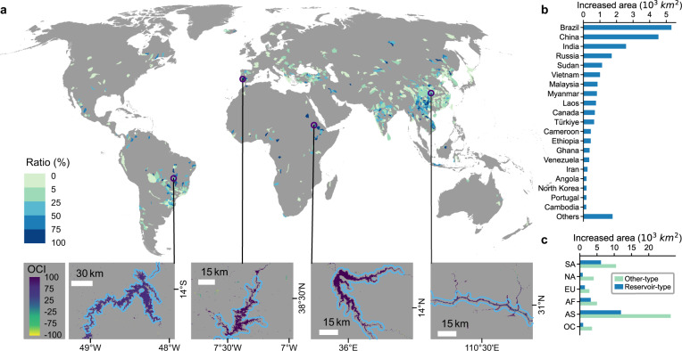
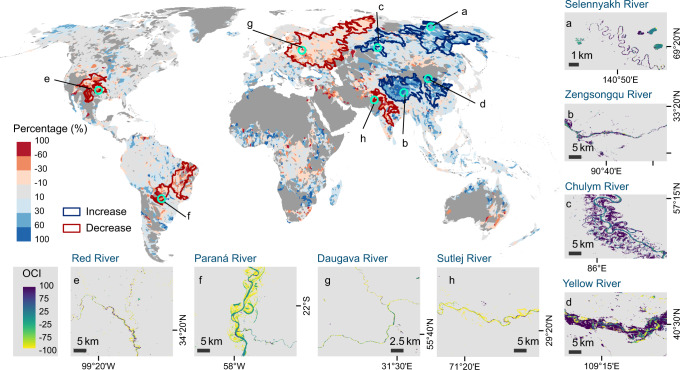
Rivers are among the most diverse, dynamic, and productive ecosystems on Earth. River flow regimes are constantly changing, but characterizing and understanding such changes have been challenging from a long-term and global perspective. By analyzing water extent variations observed from four-decade Landsat imagery, we here provide a global attribution of the recent changes in river regime to morphological dynamics (e.g., channel shifting and anabranching), expansion induced by new dams, and hydrological signals of widening and narrowing. Morphological dynamics prevailed in ~20% of the global river area. Booming reservoir constructions, mostly skewed in Asia and South America, contributed to ~32% of the river widening. The remaining hydrological signals were characterized by contrasting hotspots, including prominent river widening in alpine and pan-Arctic regions and narrowing in the arid/semi-arid continental interiors, driven by varying trends in climate forcing, cryospheric response to warming, and human water management. Our findings suggest that the recent river extent dynamics diverge based on hydroclimate and socio-economic conditions, and besides reflecting ongoing morphodynamical processes, river extent changes show close connections with external forcings, including climate change and anthropogenic interference.

摘要

河流是地球上最多样化、最具活力和生产力的生态系统之一。河川水流模式一直在不断变化,但从长期和全球角度来描述和理解这些变化一直具有挑战性。通过分析过去四十年 Landsat 图像观测到的水域范围变化,我们在此对近期河川水流模式的变化进行了全球归因分析,这些变化归因于形态动力学(例如河道迁移和叉流)、新水坝扩张以及河道展宽和收窄的水文信号。形态动力学在全球约 20%的河流流域中占主导地位。亚洲和南美洲的水库建设蓬勃发展,导致约 32%的河流展宽。其余的水文信号则以鲜明的热点为特征,包括高山和泛北极地区的河流展宽以及干旱/半干旱大陆内部的河流收窄,这是由气候驱动因素、变暖对冰冻圈的响应以及人为水资源管理的不同趋势所驱动的。我们的研究结果表明,近期的河流范围动态变化取决于水文气候和社会经济条件,并且除了反映正在进行的形态动力学过程外,河流范围的变化还与外部强迫因素密切相关,包括气候变化和人为干扰。

https://cdn.ncbi.nlm.nih.gov/pmc/blobs/34be/10033638/aa5187a6b578/41467_2023_37061_Fig8_HTML.jpg
https://cdn.ncbi.nlm.nih.gov/pmc/blobs/34be/10033638/c2c535f4e263/41467_2023_37061_Fig1_HTML.jpg
https://cdn.ncbi.nlm.nih.gov/pmc/blobs/34be/10033638/51f2fda34c2d/41467_2023_37061_Fig2_HTML.jpg
https://cdn.ncbi.nlm.nih.gov/pmc/blobs/34be/10033638/0dba54cfe6a8/41467_2023_37061_Fig3_HTML.jpg
https://cdn.ncbi.nlm.nih.gov/pmc/blobs/34be/10033638/47835e187d40/41467_2023_37061_Fig4_HTML.jpg
https://cdn.ncbi.nlm.nih.gov/pmc/blobs/34be/10033638/23e420beb562/41467_2023_37061_Fig5_HTML.jpg
https://cdn.ncbi.nlm.nih.gov/pmc/blobs/34be/10033638/db76be211fd0/41467_2023_37061_Fig6_HTML.jpg
https://cdn.ncbi.nlm.nih.gov/pmc/blobs/34be/10033638/1905b7994b23/41467_2023_37061_Fig7_HTML.jpg
https://cdn.ncbi.nlm.nih.gov/pmc/blobs/34be/10033638/aa5187a6b578/41467_2023_37061_Fig8_HTML.jpg

相似文献

1
Satellites reveal hotspots of global river extent change.卫星揭示全球河流延伸变化的热点。
Nat Commun. 2023 Mar 22;14(1):1587. doi: 10.1038/s41467-023-37061-3.
2
Using stable isotopes to assess river water dynamics and groundwater input in the largest European Arctic river (Severnaya Dvina).利用稳定同位素评估欧洲最大的北极河流(Severnaya Dvina)的河水动态和地下水输入。
Environ Monit Assess. 2020 Jun 19;192(7):444. doi: 10.1007/s10661-020-08414-y.
3
Emerging solute-induced mineralization in Arctic rivers under climate warming.气候变暖下北极河流中新兴的溶质诱导矿化作用
Sci Total Environ. 2022 Dec 10;851(Pt 1):158091. doi: 10.1016/j.scitotenv.2022.158091. Epub 2022 Aug 17.
4
Dynamics of sediment transport in the Yangtze River and their key drivers.长江泥沙输移动力学及其关键驱动因素。
Sci Total Environ. 2023 Mar 1;862:160688. doi: 10.1016/j.scitotenv.2022.160688. Epub 2022 Dec 7.
5
Multiscale morphological trajectories to support management of free-flowing rivers: the Vjosa in South-East Europe.支持自由流动河流管理的多尺度形态学轨迹:东南欧的沃约萨河
J Environ Manage. 2024 Nov;370:122541. doi: 10.1016/j.jenvman.2024.122541. Epub 2024 Oct 2.
6
ARCTIC CHANGE AND POSSIBLE INFLUENCE ON MID-LATITUDE CLIMATE AND WEATHER: A US CLIVAR White Paper.北极变化及其对中纬度气候和天气的可能影响:一份美国气候变率和可预报性研究计划(CLIVAR)白皮书
US CLIVAR Rep. 2018 Mar;n/a. doi: 10.5065/D6TH8KGW.
7
Visualisation of flooding along an unvegetated, ephemeral river using Google Earth Engine: Implications for assessment of channel-floodplain dynamics in a time of rapid environmental change.利用谷歌地球引擎对一条无植被、短暂的河流洪水进行可视化:对快速环境变化时期河道-洪泛平原动态评估的启示。
J Environ Manage. 2021 Jan 15;278(Pt 2):111559. doi: 10.1016/j.jenvman.2020.111559. Epub 2020 Nov 1.
8
Flow regime changes in the Lancang River, revealed by integrated modeling with multiple Earth observation datasets.利用多源地球观测数据集进行综合建模揭示的澜沧江水流状态变化
Sci Total Environ. 2023 Mar 1;862:160656. doi: 10.1016/j.scitotenv.2022.160656. Epub 2022 Dec 7.
9
Changes in the area of inland lakes in arid regions of central Asia during the past 30 years.过去 30 年中亚干旱地区内陆湖面积的变化。
Environ Monit Assess. 2011 Jul;178(1-4):247-56. doi: 10.1007/s10661-010-1686-y. Epub 2010 Sep 10.
10
Potential impacts of climate change on flow regime and fish habitat in mountain rivers of the south-western Balkans.气候变化对西南巴尔干山区河流流量格局和鱼类栖息地的潜在影响。
Sci Total Environ. 2016 Jan 1;540:418-28. doi: 10.1016/j.scitotenv.2015.06.134. Epub 2015 Aug 4.

引用本文的文献

1
Evaluating climate shifts and drought regions in the central Indian river basins.评估印度中部河流流域的气候变化和干旱地区。
Sci Rep. 2025 Aug 13;15(1):29701. doi: 10.1038/s41598-025-15231-1.
2
Impact of LULC changes on small watershed morphometry and delineation of sustainable conservation strategies for degraded transboundary rivers.土地利用与土地覆盖变化对小流域形态测量的影响以及退化跨境河流可持续保护策略的划定
Sci Rep. 2025 Jul 5;15(1):24063. doi: 10.1038/s41598-025-08841-2.
3
Warming degrades nutritional quality of periphyton in stream ecosystems: evidence from a mesocosm experiment.

本文引用的文献

1
How Have Global River Widths Changed Over Time?全球河流宽度随时间发生了怎样的变化?
Water Resour Res. 2022 Aug;58(8):e2021WR031712. doi: 10.1029/2021WR031712. Epub 2022 Aug 22.
2
Spatiotemporal variations in characteristic discharge in the Yangtze River downstream of the Three Gorges Dam.三峡大坝下游长江特征流量的时空变化。
Sci Total Environ. 2021 Sep 1;785:147343. doi: 10.1016/j.scitotenv.2021.147343. Epub 2021 Apr 24.
3
Threats of global warming to the world's freshwater fishes.全球变暖对世界淡水鱼类的威胁。
升温会降低溪流生态系统中周丛生物的营养质量:来自中宇宙实验的证据。
ISME Commun. 2025 Mar 23;5(1):ycaf051. doi: 10.1093/ismeco/ycaf051. eCollection 2025 Jan.
4
Big data show idiosyncratic patterns and rates of geomorphic river mobility.大数据显示出地貌河流移动的特殊模式和速率。
Nat Commun. 2025 Apr 5;16(1):3263. doi: 10.1038/s41467-025-58427-9.
5
Prolonged water body types dataset of urban agglomeration in central China from 1990 to 2021.1990年至2021年中国中部城市群长时间水体类型数据集
Sci Data. 2025 Mar 22;12(1):480. doi: 10.1038/s41597-025-04794-3.
6
Inland water greenhouse gas emissions offset the terrestrial carbon sink in the northern cryosphere.内陆水域温室气体排放抵消了北半球冰冻圈的陆地碳汇。
Sci Adv. 2024 Sep 27;10(39):eadp0024. doi: 10.1126/sciadv.adp0024.
Nat Commun. 2021 Mar 15;12(1):1701. doi: 10.1038/s41467-021-21655-w.
4
More than one million barriers fragment Europe's rivers.超过 100 万座水坝使欧洲的河流支离破碎。
Nature. 2020 Dec;588(7838):436-441. doi: 10.1038/s41586-020-3005-2. Epub 2020 Dec 16.
5
Fast response of cold ice-rich permafrost in northeast Siberia to a warming climate.东北西伯利亚富含冰的冷永久冻土对气候变暖的快速响应。
Nat Commun. 2020 May 4;11(1):2201. doi: 10.1038/s41467-020-15725-8.
6
Recent Changes in Land Water Storage and its Contribution to Sea Level Variations.陆地水储量的近期变化及其对海平面变化的贡献。
Surv Geophys. 2017;38(1):131-152. doi: 10.1007/s10712-016-9399-6. Epub 2016 Nov 15.
7
Version 4 of the CRU TS monthly high-resolution gridded multivariate climate dataset.第四版 CRU TS 月高分辨率网格化多变量气候数据集。
Sci Data. 2020 Apr 3;7(1):109. doi: 10.1038/s41597-020-0453-3.
8
Colorado River flow dwindles as warming-driven loss of reflective snow energizes evaporation.科罗拉多河的流量因变暖导致反射性积雪流失而减少,这加剧了蒸发。
Science. 2020 Mar 13;367(6483):1252-1255. doi: 10.1126/science.aay9187. Epub 2020 Feb 20.
9
Global hydro-environmental sub-basin and river reach characteristics at high spatial resolution.高空间分辨率的全球水-环境子流域和河流河段特征。
Sci Data. 2019 Dec 9;6(1):283. doi: 10.1038/s41597-019-0300-6.
10
Inland water bodies in China: Features discovered in the long-term satellite data.中国内陆水体:从长期卫星数据中发现的特征。
Proc Natl Acad Sci U S A. 2019 Dec 17;116(51):25491-25496. doi: 10.1073/pnas.1910872116. Epub 2019 Dec 2.