Applied Geoinformation Science, Geography Department, Humboldt University Berlin, Berlin, Germany.
Integrative Research Institute on Transformations of Human Environment Systems (IRI THESys), Berlin, Germany.
Front Public Health. 2023 Apr 13;11:1128452. doi: 10.3389/fpubh.2023.1128452. eCollection 2023.
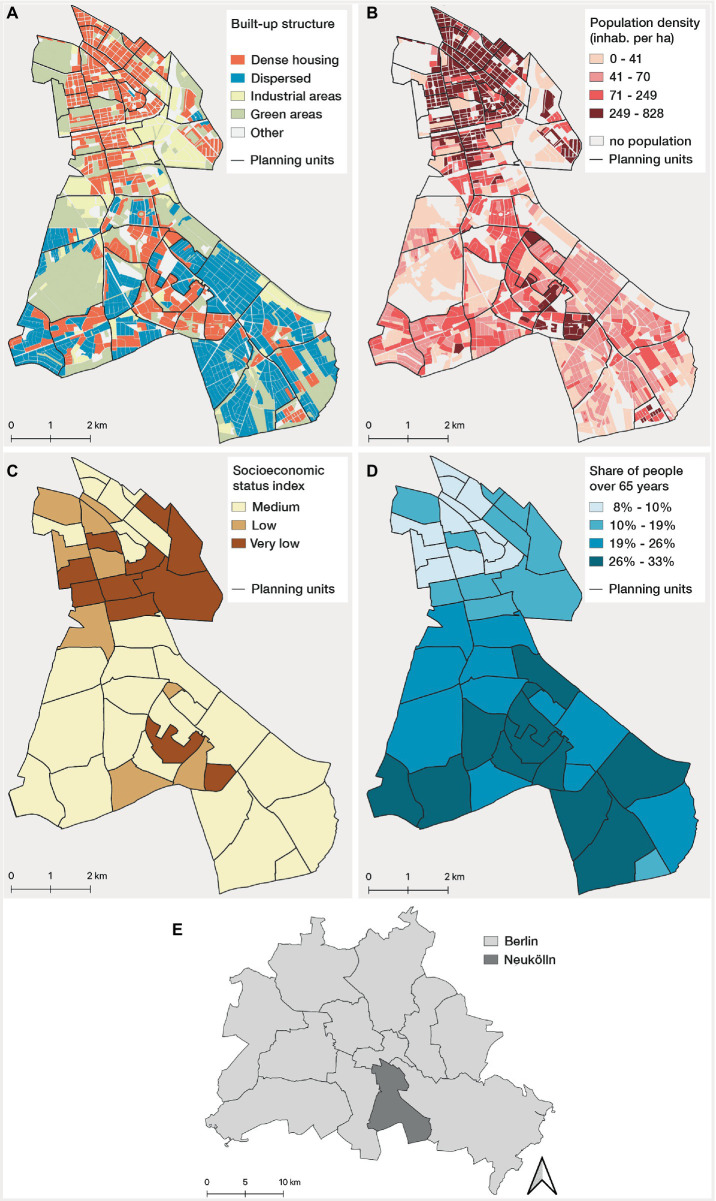
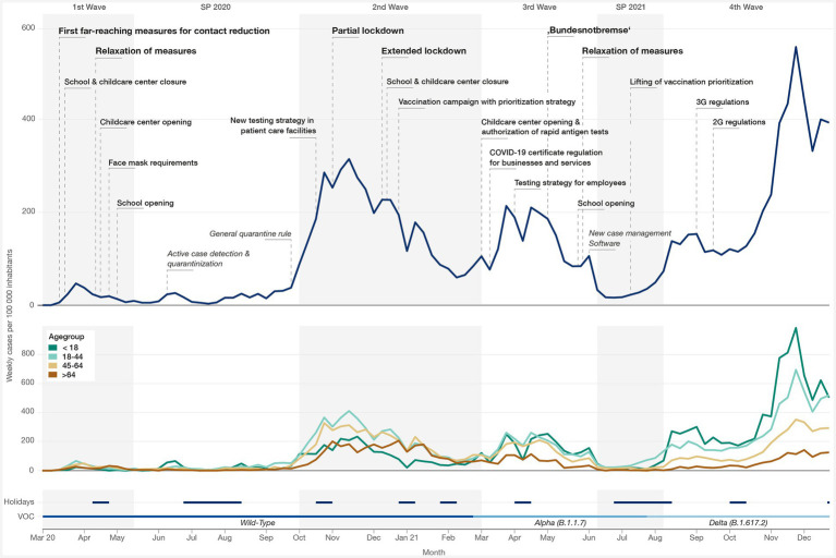
The COVID-19 pandemic represents a worldwide threat to health. Since its onset in 2019, the pandemic has proceeded in different phases, which have been shaped by a complex set of influencing factors, including public health and social measures, the emergence of new virus variants, and seasonality. Understanding the development of COVID-19 incidence and its spatiotemporal patterns at a neighborhood level is crucial for local health authorities to identify high-risk areas and develop tailored mitigation strategies. However, analyses at the neighborhood level are scarce and mostly limited to specific phases of the pandemic. The aim of this study was to explore the development of COVID-19 incidence and spatiotemporal patterns of incidence at a neighborhood scale in an intra-urban setting over several pandemic phases (March 2020-December 2021). We used reported COVID-19 case data from the health department of the district Berlin-Neukölln, Germany, additional socio-demographic data, and text documents and materials on implemented public health and social measures. We examined incidence over time in the context of the measures and other influencing factors, with a particular focus on age groups. We used incidence maps and spatial scan statistics to reveal changing spatiotemporal patterns. Our results show that several factors may have influenced the development of COVID-19 incidence. In particular, the far-reaching measures for contact reduction showed a substantial impact on incidence in Neukölln. We observed several age group-specific effects: school closures had an effect on incidence in the younger population (< 18 years), whereas the start of the vaccination campaign had an impact primarily on incidence among the elderly (> 65 years). The spatial analysis revealed that high-risk areas were heterogeneously distributed across the district. The location of high-risk areas also changed across the pandemic phases. In this study, existing intra-urban studies were supplemented by our investigation of the course of the pandemic and the underlying processes at a small scale over a long period of time. Our findings provide new insights for public health authorities, community planners, and policymakers about the spatiotemporal development of the COVID-19 pandemic at the neighborhood level. These insights are crucial for guiding decision-makers in implementing mitigation strategies.
新冠疫情大流行对全球健康构成了威胁。自 2019 年疫情爆发以来,疫情经历了不同的阶段,这些阶段受到一系列复杂因素的影响,包括公共卫生和社会措施、新病毒变异的出现和季节性。了解邻里层面新冠疫情发病情况及其时空模式对于当地卫生部门识别高风险区域和制定有针对性的缓解策略至关重要。然而,邻里层面的分析很少,而且大多仅限于疫情的特定阶段。本研究旨在探讨在城市内部环境中,跨越多个疫情阶段(2020 年 3 月至 2021 年 12 月),在邻里尺度上新冠疫情发病情况的发展和时空模式。我们使用了德国柏林-诺伊科伦区卫生部门报告的新冠病例数据、额外的社会人口数据以及有关实施公共卫生和社会措施的文本文件和材料。我们在措施和其他影响因素的背景下,研究了随时间变化的发病情况,特别关注年龄组。我们使用发病情况图和空间扫描统计数据来揭示不断变化的时空模式。我们的研究结果表明,有几个因素可能影响了新冠疫情发病情况的发展。特别是,广泛的减少接触措施对诺伊科伦的发病情况产生了实质性影响。我们观察到了几个年龄组特定的影响:学校关闭对年轻人群(<18 岁)的发病情况有影响,而疫苗接种运动的开始主要对老年人(>65 岁)的发病情况产生影响。空间分析表明,高风险区域在整个地区呈不均匀分布。高风险区域的位置在疫情各阶段也发生了变化。在本研究中,我们对疫情的发展和长期小范围内的潜在过程进行了调查,补充了现有的城市内研究。我们的研究结果为公共卫生部门、社区规划者和决策者提供了邻里层面新冠疫情时空发展的新见解。这些见解对于指导决策者实施缓解策略至关重要。