• 文献检索
  • 文档翻译
  • 深度研究
  • 学术资讯
  • Suppr Zotero 插件Zotero 插件
  • 邀请有礼
  • 套餐&价格
  • 历史记录
应用&插件
Suppr Zotero 插件Zotero 插件浏览器插件Mac 客户端Windows 客户端微信小程序
定价
高级版会员购买积分包购买API积分包
服务
文献检索文档翻译深度研究API 文档MCP 服务
关于我们
关于 Suppr公司介绍联系我们用户协议隐私条款
关注我们

Suppr 超能文献

核心技术专利:CN118964589B侵权必究
粤ICP备2023148730 号-1Suppr @ 2026

文献检索

告别复杂PubMed语法,用中文像聊天一样搜索,搜遍4000万医学文献。AI智能推荐,让科研检索更轻松。

立即免费搜索

文件翻译

保留排版,准确专业,支持PDF/Word/PPT等文件格式,支持 12+语言互译。

免费翻译文档

深度研究

AI帮你快速写综述,25分钟生成高质量综述,智能提取关键信息,辅助科研写作。

立即免费体验

利用并行地理编码分析尼日利亚拉各斯道路交通伤害事件的空间特征。

Using parallel geocoding to analyse the spatial characteristics of road traffic injury occurrences across Lagos, Nigeria.

机构信息

School of Economic, Political and Policy Sciences, University of Texas at Dallas, Richardson, Texas, USA.

School of Economic, Political and Policy Sciences, University of Texas at Dallas, Richardson, Texas, USA

出版信息

BMJ Glob Health. 2023 May;8(5). doi: 10.1136/bmjgh-2023-012315.

DOI:10.1136/bmjgh-2023-012315
PMID:37217236
原文链接:https://pmc.ncbi.nlm.nih.gov/articles/PMC10230918/
Abstract

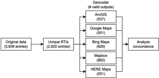
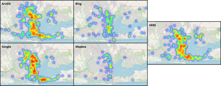
While efforts to understand and mitigate road traffic injury (RTI) occurrence have long been underway in high-income countries, similar projects in low/middle-income countries (LMICs) are frequently hindered by institutional and informational obstacles. Technological advances in geospatial analysis provide a pathway to overcome a subset of these barriers, and in doing so enable researchers to create actionable insights in the pursuit of mitigating RTI-associated negative health outcomes. This analysis develops a parallel geocoding workflow to improve investigation of low-fidelity datasets common in LMICs. Subsequently, this workflow is applied to and evaluated on an RTI dataset from Lagos State, Nigeria, minimising positional error in geocoding by incorporating outputs from four commercially available geocoders. The concordance between outputs from these geocoders is evaluated, and spatial visualisations are generated to provide insight into the distribution of RTI occurrence within the analysis region. This study highlights the implications of geospatial data analysis in LMICs facilitated by modern technologies on health resource allocation, and ultimately, patient outcomes.

摘要

尽管高收入国家长期以来一直在努力了解和减轻道路交通伤害(RTI)的发生,但类似的低/中收入国家(LMICs)项目经常受到制度和信息障碍的阻碍。地理空间分析技术的进步为克服其中一部分障碍提供了途径,使研究人员能够在追求减轻与 RTI 相关的负面健康结果方面创造可行的见解。本分析开发了一种并行地理编码工作流程,以改进对 LMIC 中常见的低保真数据集的调查。随后,该工作流程应用于并在来自尼日利亚拉各斯州的 RTI 数据集上进行了评估,通过整合来自四个商业地理编码器的输出,最大限度地减少地理编码中的位置误差。评估这些地理编码器输出之间的一致性,并生成空间可视化,以深入了解分析区域内 RTI 发生的分布情况。本研究强调了现代技术促进的 LMIC 中地理空间数据分析对卫生资源分配的影响,最终对患者的治疗结果产生影响。

https://cdn.ncbi.nlm.nih.gov/pmc/blobs/d91f/10230918/2bcc13132dc4/bmjgh-2023-012315f05.jpg
https://cdn.ncbi.nlm.nih.gov/pmc/blobs/d91f/10230918/1f6975369a50/bmjgh-2023-012315f01.jpg
https://cdn.ncbi.nlm.nih.gov/pmc/blobs/d91f/10230918/9f17cab54a98/bmjgh-2023-012315f02.jpg
https://cdn.ncbi.nlm.nih.gov/pmc/blobs/d91f/10230918/7406572b619f/bmjgh-2023-012315f03.jpg
https://cdn.ncbi.nlm.nih.gov/pmc/blobs/d91f/10230918/8fce0f428f66/bmjgh-2023-012315f04.jpg
https://cdn.ncbi.nlm.nih.gov/pmc/blobs/d91f/10230918/2bcc13132dc4/bmjgh-2023-012315f05.jpg

相似文献

1
Using parallel geocoding to analyse the spatial characteristics of road traffic injury occurrences across Lagos, Nigeria.利用并行地理编码分析尼日利亚拉各斯道路交通伤害事件的空间特征。
BMJ Glob Health. 2023 May;8(5). doi: 10.1136/bmjgh-2023-012315.
2
A cross-sectional ecological analysis of international and sub-national health inequalities in commercial geospatial resource availability.跨国别和国家级的商业地理空间资源可及性与健康不平等的横断生态学分析。
Int J Health Geogr. 2018 May 23;17(1):14. doi: 10.1186/s12942-018-0134-z.
3
Road Traffic Injury in Lagos, Nigeria: Assessing Prehospital Care.尼日利亚拉各斯的道路交通伤害:评估院前护理。
Prehosp Disaster Med. 2017 Aug;32(4):424-430. doi: 10.1017/S1049023X17006410. Epub 2017 May 2.
4
When policy meets the pedal: A reduction in motorcyclist fatalities following the implementation of a road traffic law in Lagos, Nigeria.当政策触及踏板:尼日利亚拉各斯实施道路交通法后,摩托车手死亡人数减少。
Traffic Inj Prev. 2019;20(8):849-853. doi: 10.1080/15389588.2019.1663346. Epub 2019 Oct 24.
5
A research agenda: does geocoding positional error matter in health GIS studies?一项研究议程:地理编码位置误差在健康地理信息系统研究中重要吗?
Spat Spatiotemporal Epidemiol. 2012 Apr;3(1):7-16. doi: 10.1016/j.sste.2012.02.002. Epub 2012 Feb 14.
6
Effect of geocoding errors on traffic-related air pollutant exposure and concentration estimates.地理编码错误对与交通相关的空气污染物暴露及浓度估算的影响。
J Expo Sci Environ Epidemiol. 2015 Sep-Oct;25(5):490-8. doi: 10.1038/jes.2015.1. Epub 2015 Feb 11.
7
Decreasing Trends in Road Traffic Injury Incidence and Mortality in Nigeria: A Ten-Year Analysis.尼日利亚道路交通伤害发生率和死亡率呈下降趋势:十年分析。
J Surg Res. 2020 May;249:163-167. doi: 10.1016/j.jss.2019.11.033. Epub 2020 Jan 23.
8
Household economic impact of road traffic injury versus routine emergencies in a low-income country.道路交通伤害与低收入国家常规紧急情况对家庭经济的影响。
Injury. 2021 Sep;52(9):2657-2664. doi: 10.1016/j.injury.2021.06.007. Epub 2021 Jun 20.
9
Geographic analysis of road accident severity index in Nigeria.尼日利亚道路交通事故严重程度指数的地理分析。
Int J Inj Contr Saf Promot. 2019 Mar;26(1):72-81. doi: 10.1080/17457300.2018.1476387. Epub 2018 May 28.
10
Predictors of road traffic accident, road traffic injury and death among commercial motorcyclists in an urban area of Nigeria.尼日利亚某城市地区商业摩托车骑手道路交通事故、道路交通伤害及死亡的预测因素
Niger J Med. 2009 Oct-Dec;18(4):393-7. doi: 10.4314/njm.v18i4.51250.

本文引用的文献

1
Modeling spatial access to cervical cancer screening services in Ondo State, Nigeria.尼日利亚翁多州宫颈癌筛查服务的空间可达性建模。
Int J Health Geogr. 2020 Jul 21;19(1):28. doi: 10.1186/s12942-020-00222-4.
2
Prevalence and determinants of post-traumatic stress disorder among road traffic accident survivors: a prospective survey at selected hospitals in southern Ethiopia.埃塞俄比亚南部选定医院中道路交通伤幸存者创伤后应激障碍的发生率及其决定因素:一项前瞻性调查。
BMC Emerg Med. 2020 Jun 26;20(1):52. doi: 10.1186/s12873-020-00348-5.
3
Lagos state ambulance service: a performance evaluation.
拉各斯州救护车服务:绩效评估。
Eur J Trauma Emerg Surg. 2021 Oct;47(5):1591-1598. doi: 10.1007/s00068-020-01319-y. Epub 2020 Mar 10.
4
Adult mortality in sub-Saharan Africa: cross-sectional study of causes of death in Zambia.撒哈拉以南非洲地区成年人死亡率:赞比亚死亡原因的横断面研究。
Trop Med Int Health. 2019 Oct;24(10):1208-1220. doi: 10.1111/tmi.13302. Epub 2019 Sep 11.
5
Response time in the emergency services. Systematic review.紧急服务中的响应时间。系统评价。
Acta Cir Bras. 2018 Dec;33(12):1110-1121. doi: 10.1590/s0102-865020180120000009.
6
A cross-sectional ecological analysis of international and sub-national health inequalities in commercial geospatial resource availability.跨国别和国家级的商业地理空间资源可及性与健康不平等的横断生态学分析。
Int J Health Geogr. 2018 May 23;17(1):14. doi: 10.1186/s12942-018-0134-z.
7
Geospatial relationship of road traffic crashes and healthcare facilities with trauma surgical capabilities in Nairobi, Kenya: defining gaps in coverage.肯尼亚内罗毕道路交通事故与具备创伤外科能力的医疗保健设施的地理空间关系:确定覆盖范围的差距。
Trauma Surg Acute Care Open. 2017 Dec 7;2(1):e000130. doi: 10.1136/tsaco-2017-000130. eCollection 2017.
8
Road Traffic Injury Prevention Initiatives: A Systematic Review and Metasummary of Effectiveness in Low and Middle Income Countries.道路交通事故预防举措:低收入和中等收入国家有效性的系统评价与元总结
PLoS One. 2016 Jan 6;11(1):e0144971. doi: 10.1371/journal.pone.0144971. eCollection 2016.
9
UpSet: Visualization of Intersecting Sets.UpSet:相交集的可视化
IEEE Trans Vis Comput Graph. 2014 Dec;20(12):1983-92. doi: 10.1109/TVCG.2014.2346248.
10
Methods to measure potential spatial access to delivery care in low- and middle-income countries: a case study in rural Ghana.衡量中低收入国家获得分娩护理的潜在空间可达性的方法:以加纳农村为例的一项案例研究。
Int J Health Geogr. 2014 Jun 26;13:25. doi: 10.1186/1476-072X-13-25.