Andrade-Rivas Federico, Paul Naman, Spiegel Jerry, Henderson Sarah B, Parrott Lael, Delgado-Ron Jorge Andrés, Echeverri Alejandra, van den Bosch Matilda
School of Population and Public Health The University of British Columbia Vancouver BC Canada.
Instituto de Salud y Ambiente Universidad El Bosque Bogotá Colombia.
Geohealth. 2023 Jul 7;7(7):e2022GH000775. doi: 10.1029/2022GH000775. eCollection 2023 Jul.
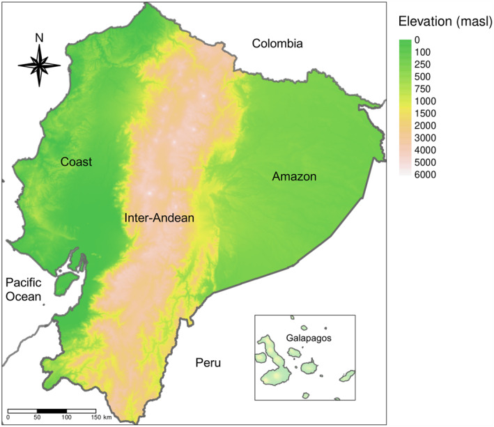
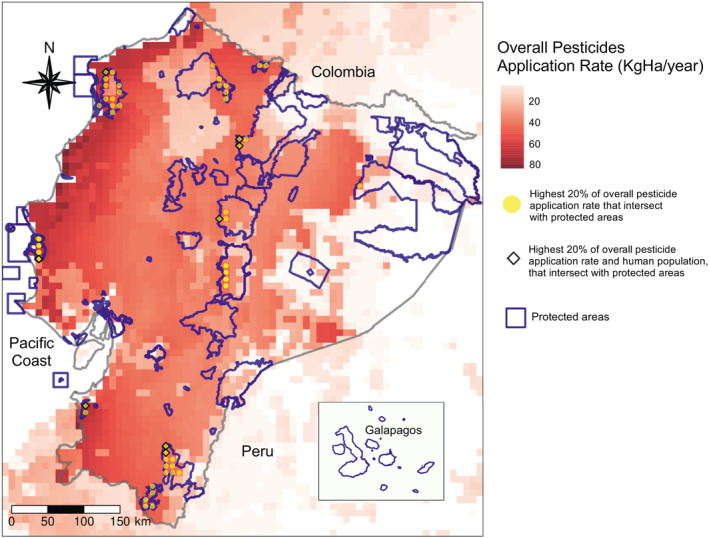
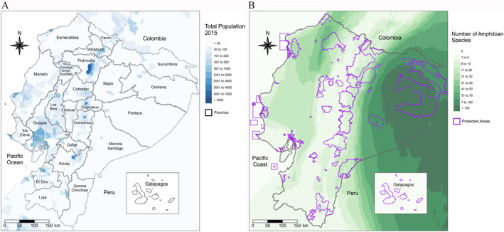
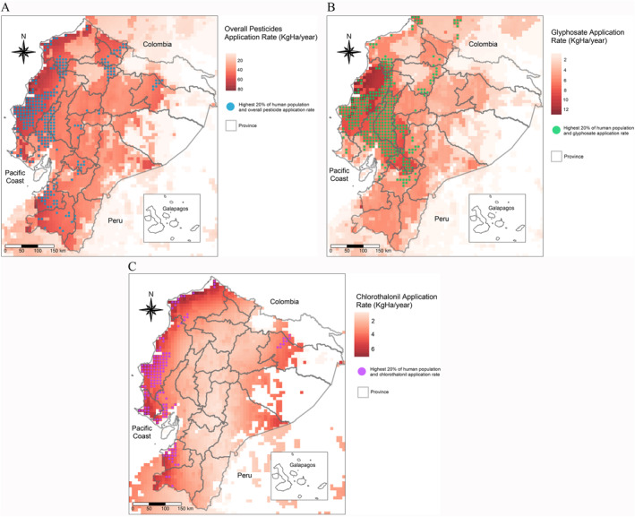
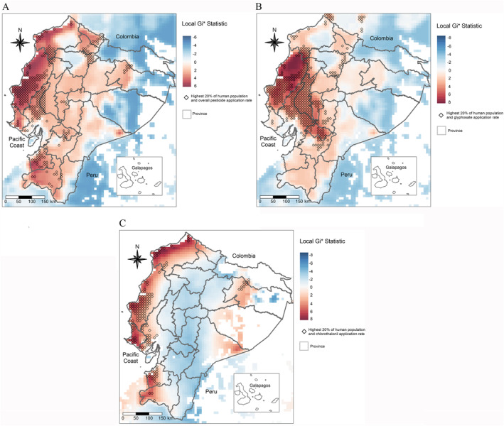
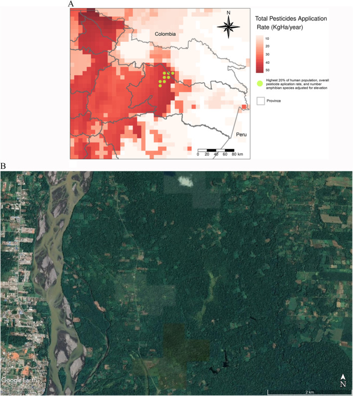
Human populations and ecosystems are extensively exposed to pesticides. Most nations lack the capacity to control pesticide contamination and have limited availability of pesticide use information. Ecuador is a country with intense pesticide use with high exposure risks to humans and the environment, although relative or combined risks are not well understood. Here, we analyzed the distribution of application rates in Ecuador and identified regions of concern because of high potential exposure. We used a geospatial analysis to identify grid cells (∼8 km × 8 km) where the highest pesticide application rates and density of human populations overlap. Furthermore, we identified other regions of concern based on the number of amphibian species as an indicator of ecosystem integrity and the location of natural protected areas. We found that 28% of Ecuador's population dwelled in areas with high pesticide application rate. We identified an area of ∼512 km in the Amazon region where high application rates, large human settlements, and a high number of amphibian species overlapped. Additionally, we distinguished clusters of pesticide application rates and human populations that intersected with natural protected areas. Ecuador exemplifies how pesticides are disproportionately applied in areas with the potential to affect human health and ecosystems' integrity. Global estimates of population dwelling, pesticide application rates, and environmental factors are key in prioritizing locations to conduct further exposure assessments. The modular and scalable nature of the geospatial tools we developed can be expanded and adapted to other regions of the world where data on pesticide use are limited.
人类种群和生态系统广泛接触农药。大多数国家缺乏控制农药污染的能力,且农药使用信息的可得性有限。厄瓜多尔是一个农药使用密集的国家,人类和环境面临的暴露风险很高,尽管相对风险或综合风险尚未得到充分了解。在此,我们分析了厄瓜多尔农药施用量的分布情况,并确定了因潜在高暴露风险而值得关注的区域。我们使用地理空间分析来确定农药施用量最高且人口密度最大的网格单元(约8公里×8公里)。此外,我们还根据两栖动物物种数量作为生态系统完整性的指标以及自然保护区的位置,确定了其他值得关注的区域。我们发现,厄瓜多尔28%的人口居住在农药施用量高的地区。我们在亚马逊地区确定了一个面积约512平方公里的区域,该区域农药施用量高、人类聚居区大且两栖动物物种数量多。此外,我们还区分了与自然保护区相交的农药施用量和人口集群。厄瓜多尔例证了农药如何不成比例地施用于有可能影响人类健康和生态系统完整性的地区。全球范围内对人口居住情况、农药施用量和环境因素的估计对于确定进行进一步暴露评估的优先地点至关重要。我们开发的地理空间工具具有模块化和可扩展性,可扩展并适用于世界上其他农药使用数据有限的地区。