• 文献检索
  • 文档翻译
  • 深度研究
  • 学术资讯
  • Suppr Zotero 插件Zotero 插件
  • 邀请有礼
  • 套餐&价格
  • 历史记录
应用&插件
Suppr Zotero 插件Zotero 插件浏览器插件Mac 客户端Windows 客户端微信小程序
定价
高级版会员购买积分包购买API积分包
服务
文献检索文档翻译深度研究API 文档MCP 服务
关于我们
关于 Suppr公司介绍联系我们用户协议隐私条款
关注我们

Suppr 超能文献

核心技术专利:CN118964589B侵权必究
粤ICP备2023148730 号-1Suppr @ 2026

文献检索

告别复杂PubMed语法,用中文像聊天一样搜索,搜遍4000万医学文献。AI智能推荐,让科研检索更轻松。

立即免费搜索

文件翻译

保留排版,准确专业,支持PDF/Word/PPT等文件格式,支持 12+语言互译。

免费翻译文档

深度研究

AI帮你快速写综述,25分钟生成高质量综述,智能提取关键信息,辅助科研写作。

立即免费体验

利用 Sentinel-1 的轨道稳定性,实现辐射地形校正 Γ 零后向散射的高效预处理。

Utilising Sentinel-1's Orbital Stability for Efficient Pre-Processing of Radiometric Terrain Corrected Gamma Nought Backscatter.

机构信息

Department of Geodesy and Geoinformation, TU Wien, 1040 Vienna, Austria.

Earth Observation Data Centre for Water Resources Monitoring (EODC), 1030 Vienna, Austria.

出版信息

Sensors (Basel). 2023 Jul 1;23(13):6072. doi: 10.3390/s23136072.

DOI:10.3390/s23136072
PMID:37447922
原文链接:https://pmc.ncbi.nlm.nih.gov/articles/PMC10346578/
Abstract

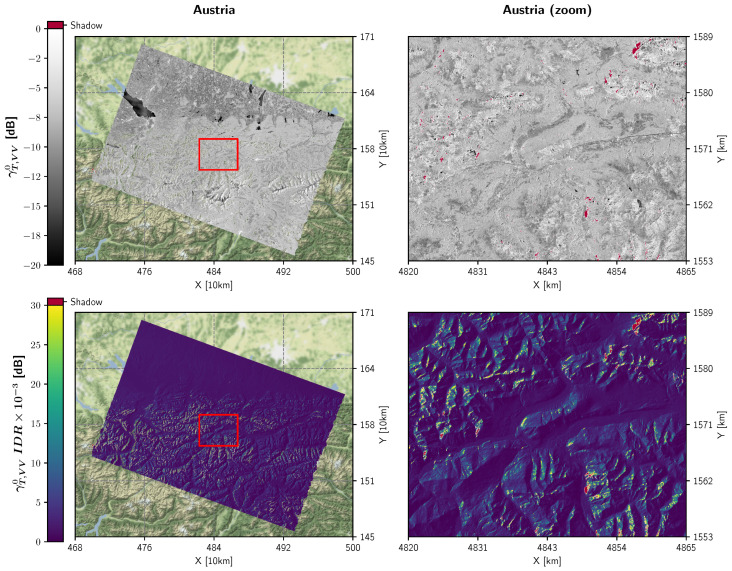
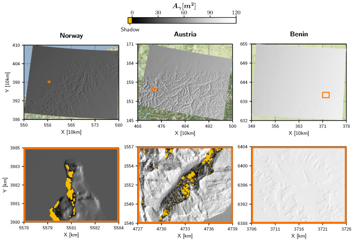
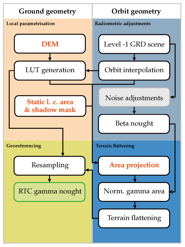
Radiometric Terrain Corrected (RTC) gamma nought backscatter, which was introduced around a decade ago, has evolved into the standard for analysis-ready Synthetic Aperture Radar (SAR) data. While working with RTC backscatter data is particularly advantageous over undulated terrain, it requires substantial computing resources given that the terrain flattening is more computationally demanding than simple orthorectification. The extra computation may become problematic when working with large SAR datasets such as the one provided by the Sentinel-1 mission. In this study, we examine existing Sentinel-1 RTC pre-processing workflows and assess ways to reduce processing and storage overheads by considering the satellite's high orbital stability. By propagating Sentinel-1's orbital deviations through the complete pre-processing chain, we show that the local contributing area and the shadow mask can be assumed to be static for each relative orbit. Providing them as a combined external static layer to the pre-processing workflow, and streamlining the transformations between ground and orbit geometry, reduces the overall processing times by half. We conducted our experiments with our in-house developed toolbox named , which allowed us to analyse various aspects of RTC, specifically run time performance, oversampling, and radiometric quality. Compared to the Sentinel Application Platform (SNAP) this implementation allowed speeding up processing by factors of 10-50. The findings of this study are not just relevant for Sentinel-1 but for all SAR missions with high spatio-temporal coverage and orbital stability.

摘要

辐射地形校正(RTC)零伽马后向散射大约在十年前引入,已成为分析就绪的合成孔径雷达(SAR)数据的标准。虽然与 RTC 后向散射数据一起使用对于起伏地形特别有利,但由于地形平滑比简单的正射校正要求更高的计算资源,因此需要大量的计算资源。当处理大型 SAR 数据集(如 Sentinel-1 任务提供的数据集)时,额外的计算可能会成为问题。在本研究中,我们检查了现有的 Sentinel-1 RTC 预处理工作流程,并评估了通过考虑卫星高轨道稳定性来降低处理和存储开销的方法。通过将 Sentinel-1 的轨道偏差传播到完整的预处理链中,我们表明对于每个相对轨道,局部贡献区域和阴影掩模可以被视为静态的。将它们作为组合的外部静态层提供给预处理工作流程,并简化地面和轨道几何之间的变换,可以将总处理时间缩短一半。我们使用我们内部开发的名为的工具包进行了实验,该工具包允许我们分析 RTC 的各个方面,特别是运行时性能、过采样和辐射质量。与 Sentinel 应用平台(SNAP)相比,这种实现可以将处理速度提高 10-50 倍。这项研究的结果不仅与 Sentinel-1 相关,而且与所有具有高时空覆盖范围和轨道稳定性的 SAR 任务相关。

https://cdn.ncbi.nlm.nih.gov/pmc/blobs/ad68/10346578/fb3d553d4eea/sensors-23-06072-g007.jpg
https://cdn.ncbi.nlm.nih.gov/pmc/blobs/ad68/10346578/0d6bf5428bbb/sensors-23-06072-g001.jpg
https://cdn.ncbi.nlm.nih.gov/pmc/blobs/ad68/10346578/a55954ecf6c8/sensors-23-06072-g002.jpg
https://cdn.ncbi.nlm.nih.gov/pmc/blobs/ad68/10346578/b96cd95c4e9f/sensors-23-06072-g003.jpg
https://cdn.ncbi.nlm.nih.gov/pmc/blobs/ad68/10346578/3c31afd3d8f2/sensors-23-06072-g004.jpg
https://cdn.ncbi.nlm.nih.gov/pmc/blobs/ad68/10346578/f805a0f73f4e/sensors-23-06072-g005.jpg
https://cdn.ncbi.nlm.nih.gov/pmc/blobs/ad68/10346578/7dd4a6d5d2b4/sensors-23-06072-g006.jpg
https://cdn.ncbi.nlm.nih.gov/pmc/blobs/ad68/10346578/fb3d553d4eea/sensors-23-06072-g007.jpg

相似文献

1
Utilising Sentinel-1's Orbital Stability for Efficient Pre-Processing of Radiometric Terrain Corrected Gamma Nought Backscatter.利用 Sentinel-1 的轨道稳定性,实现辐射地形校正 Γ 零后向散射的高效预处理。
Sensors (Basel). 2023 Jul 1;23(13):6072. doi: 10.3390/s23136072.
2
Application of C-band sentinel-1A SAR data as proxies for detecting oil spills of Chennai, East Coast of India.应用C波段哨兵-1A合成孔径雷达数据作为检测印度东海岸钦奈石油泄漏的替代数据。
Mar Pollut Bull. 2022 Jan;174:113182. doi: 10.1016/j.marpolbul.2021.113182. Epub 2021 Nov 26.
3
Temporal Stability of Soil Moisture and Radar Backscatter Observed by the Advanced Synthetic Aperture Radar (ASAR).先进合成孔径雷达(ASAR)观测的土壤湿度和雷达后向散射的时间稳定性
Sensors (Basel). 2008 Feb 21;8(2):1174-1197. doi: 10.3390/s80201174.
4
ALOS-2 L-band SAR backscatter data improves the estimation and temporal transferability of wildfire effects on soil properties under different post-fire vegetation responses.ALOS-2 L 波段 SAR 后向散射数据提高了不同林火后植被响应下野火对土壤性质影响的估算和时间可转移性。
Sci Total Environ. 2022 Oct 10;842:156852. doi: 10.1016/j.scitotenv.2022.156852. Epub 2022 Jun 22.
5
Land cover mapping using Sentinel-1 SAR and Landsat 8 imageries of Lagos State for 2017.利用 2017 年的 Sentinel-1 SAR 和 Landsat 8 影像进行拉各斯州的土地覆盖制图。
Environ Sci Pollut Res Int. 2020 Jan;27(1):66-74. doi: 10.1007/s11356-019-05589-x. Epub 2019 Jun 14.
6
Global seasonal Sentinel-1 interferometric coherence and backscatter data set.全球季节性哨兵-1干涉相干性和后向散射数据集。
Sci Data. 2022 Mar 11;9(1):73. doi: 10.1038/s41597-022-01189-6.
7
Exploitation of optical and SAR amplitude imagery for landslide identification: a case study from Sikkim, Northeast India.利用光学和 SAR 幅度图像进行滑坡识别:来自印度东北部锡金邦的案例研究。
Environ Monit Assess. 2021 Jun 5;193(7):386. doi: 10.1007/s10661-021-09119-6.
8
Integration of high-resolution optical and SAR satellite remote sensing datasets for aboveground biomass estimation in subtropical pine forest, Pakistan.利用高分辨率光学和 SAR 卫星遥感数据集融合估算巴基斯坦亚热带松林地上生物量。
Environ Monit Assess. 2020 Aug 17;192(9):584. doi: 10.1007/s10661-020-08546-1.
9
The normalised Sentinel-1 Global Backscatter Model, mapping Earth's land surface with C-band microwaves.归一化哨兵-1全球后向散射模型,用C波段微波绘制地球陆地表面图。
Sci Data. 2021 Oct 28;8(1):277. doi: 10.1038/s41597-021-01059-7.
10
Effects of optical and radar satellite observations within Google Earth Engine on soil organic carbon prediction models in Spain.谷歌地球引擎中光学和雷达卫星观测对西班牙土壤有机碳预测模型的影响。
J Environ Manage. 2023 Jul 15;338:117810. doi: 10.1016/j.jenvman.2023.117810. Epub 2023 Mar 30.

引用本文的文献

1
Dataset of Sentinel-1 SAR and Sentinel-2 RGB-NDVI imagery.哨兵-1合成孔径雷达(SAR)和哨兵-2 RGB-NDVI图像数据集。
Data Brief. 2024 Nov 20;57:111160. doi: 10.1016/j.dib.2024.111160. eCollection 2024 Dec.

本文引用的文献

1
Global seasonal Sentinel-1 interferometric coherence and backscatter data set.全球季节性哨兵-1干涉相干性和后向散射数据集。
Sci Data. 2022 Mar 11;9(1):73. doi: 10.1038/s41597-022-01189-6.
2
The normalised Sentinel-1 Global Backscatter Model, mapping Earth's land surface with C-band microwaves.归一化哨兵-1全球后向散射模型,用C波段微波绘制地球陆地表面图。
Sci Data. 2021 Oct 28;8(1):277. doi: 10.1038/s41597-021-01059-7.