• 文献检索
  • 文档翻译
  • 深度研究
  • 学术资讯
  • Suppr Zotero 插件Zotero 插件
  • 邀请有礼
  • 套餐&价格
  • 历史记录
应用&插件
Suppr Zotero 插件Zotero 插件浏览器插件Mac 客户端Windows 客户端微信小程序
定价
高级版会员购买积分包购买API积分包
服务
文献检索文档翻译深度研究API 文档MCP 服务
关于我们
关于 Suppr公司介绍联系我们用户协议隐私条款
关注我们

Suppr 超能文献

核心技术专利:CN118964589B侵权必究
粤ICP备2023148730 号-1Suppr @ 2026

文献检索

告别复杂PubMed语法,用中文像聊天一样搜索,搜遍4000万医学文献。AI智能推荐,让科研检索更轻松。

立即免费搜索

文件翻译

保留排版,准确专业,支持PDF/Word/PPT等文件格式,支持 12+语言互译。

免费翻译文档

深度研究

AI帮你快速写综述,25分钟生成高质量综述,智能提取关键信息,辅助科研写作。

立即免费体验

全球城乡交错带

The global wildland-urban interface.

机构信息

SILVIS Lab, Department of Forest and Wildlife Ecology, University of Wisconsin-Madison, Madison, WI, USA.

Department of Biology and Environment, University of Haifa at Oranim, Kiryat Tivon, Israel.

出版信息

Nature. 2023 Sep;621(7977):94-99. doi: 10.1038/s41586-023-06320-0. Epub 2023 Jul 19.

DOI:10.1038/s41586-023-06320-0
PMID:37468636
原文链接:https://pmc.ncbi.nlm.nih.gov/articles/PMC10482693/
Abstract

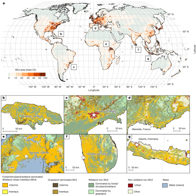
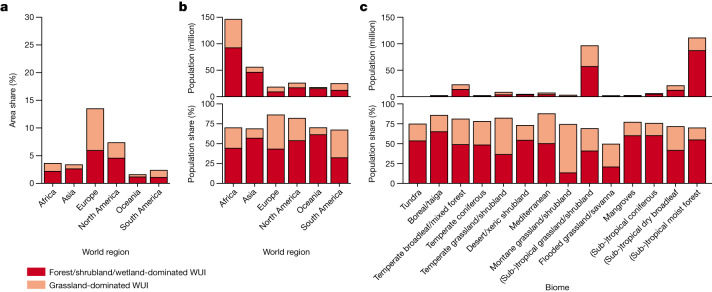
The wildland-urban interface (WUI) is where buildings and wildland vegetation meet or intermingle. It is where human-environmental conflicts and risks can be concentrated, including the loss of houses and lives to wildfire, habitat loss and fragmentation and the spread of zoonotic diseases. However, a global analysis of the WUI has been lacking. Here, we present a global map of the 2020 WUI at 10 m resolution using a globally consistent and validated approach based on remote sensing-derived datasets of building area and wildland vegetation. We show that the WUI is a global phenomenon, identify many previously undocumented WUI hotspots and highlight the wide range of population density, land cover types and biomass levels in different parts of the global WUI. The WUI covers only 4.7% of the land surface but is home to nearly half its population (3.5 billion). The WUI is especially widespread in Europe (15% of the land area) and the temperate broadleaf and mixed forests biome (18%). Of all people living near 2003-2020 wildfires (0.4 billion), two thirds have their home in the WUI, most of them in Africa (150 million). Given that wildfire activity is predicted to increase because of climate change in many regions, there is a need to understand housing growth and vegetation patterns as drivers of WUI change.

摘要

荒地-城市交界带(WUI)是指建筑物和野生植被相遇或混合的地方。这里是人类与环境冲突和风险集中的地方,包括房屋和生命因野火、栖息地丧失和破碎化以及人畜共患疾病传播而损失。然而,目前还缺乏对 WUI 的全球分析。在这里,我们使用基于遥感衍生的建筑物面积和野生植被数据集的全球一致且经过验证的方法,呈现了一张分辨率为 10 米的 2020 年 WUI 全球地图。我们表明,WUI 是一种全球性现象,确定了许多以前未记录的 WUI 热点,并突出显示了全球 WUI 不同地区人口密度、土地覆盖类型和生物量水平的广泛范围。WUI 仅覆盖 4.7%的土地表面,但却容纳了近一半的人口(35 亿)。WUI 在欧洲(占土地面积的 15%)和温带阔叶林和混合林生物群落(18%)中尤为广泛。在所有生活在 2003-2020 年野火附近的人(4 亿)中,三分之二的人居住在 WUI,其中大部分在非洲(1.5 亿)。由于气候变化预计会在许多地区增加野火活动,因此需要了解住房增长和植被模式作为 WUI 变化的驱动因素。

https://cdn.ncbi.nlm.nih.gov/pmc/blobs/18ea/10482693/a5d086ae36d5/41586_2023_6320_Fig10_ESM.jpg
https://cdn.ncbi.nlm.nih.gov/pmc/blobs/18ea/10482693/0618c06229ec/41586_2023_6320_Fig1_HTML.jpg
https://cdn.ncbi.nlm.nih.gov/pmc/blobs/18ea/10482693/49540c33544e/41586_2023_6320_Fig2_HTML.jpg
https://cdn.ncbi.nlm.nih.gov/pmc/blobs/18ea/10482693/2e94f1b4dea3/41586_2023_6320_Fig3_HTML.jpg
https://cdn.ncbi.nlm.nih.gov/pmc/blobs/18ea/10482693/2a078b532c86/41586_2023_6320_Fig4_ESM.jpg
https://cdn.ncbi.nlm.nih.gov/pmc/blobs/18ea/10482693/085385adca44/41586_2023_6320_Fig5_ESM.jpg
https://cdn.ncbi.nlm.nih.gov/pmc/blobs/18ea/10482693/fa7de940b33f/41586_2023_6320_Fig6_ESM.jpg
https://cdn.ncbi.nlm.nih.gov/pmc/blobs/18ea/10482693/32152679e718/41586_2023_6320_Fig7_ESM.jpg
https://cdn.ncbi.nlm.nih.gov/pmc/blobs/18ea/10482693/798c4dbe497a/41586_2023_6320_Fig8_ESM.jpg
https://cdn.ncbi.nlm.nih.gov/pmc/blobs/18ea/10482693/9dd434710a72/41586_2023_6320_Fig9_ESM.jpg
https://cdn.ncbi.nlm.nih.gov/pmc/blobs/18ea/10482693/a5d086ae36d5/41586_2023_6320_Fig10_ESM.jpg

相似文献

1
The global wildland-urban interface.全球城乡交错带
Nature. 2023 Sep;621(7977):94-99. doi: 10.1038/s41586-023-06320-0. Epub 2023 Jul 19.
2
Rapid growth of the US wildland-urban interface raises wildfire risk.美国城乡交错带的快速发展增加了野火风险。
Proc Natl Acad Sci U S A. 2018 Mar 27;115(13):3314-3319. doi: 10.1073/pnas.1718850115. Epub 2018 Mar 12.
3
The wildland-urban interface in the United States based on 125 million building locations.美国基于 1.25 亿个建筑物位置的城乡交错带。
Ecol Appl. 2022 Jul;32(5):e2597. doi: 10.1002/eap.2597. Epub 2022 Jun 5.
4
Assessing wildfire exposure in the Wildland-Urban Interface area of the mountains of central Argentina.评估阿根廷中部山区城乡交错带的野火暴露情况。
J Environ Manage. 2017 Jul 1;196:499-510. doi: 10.1016/j.jenvman.2017.03.058. Epub 2017 Mar 25.
5
Mapping the wildland-urban interface at municipal level for wildfire exposure analysis in mainland Portugal.在大陆葡萄牙,为进行野火暴露分析,在市级层面绘制城乡交错带图谱。
J Environ Manage. 2024 Sep;368:122098. doi: 10.1016/j.jenvman.2024.122098. Epub 2024 Aug 9.
6
Mapping the wildland-urban interface in California using remote sensing data.利用遥感数据绘制加利福尼亚州的城乡结合部地图。
Sci Rep. 2022 Apr 6;12(1):5789. doi: 10.1038/s41598-022-09707-7.
7
Mapping regional patterns of large forest fires in Wildland-Urban Interface areas in Europe.绘制欧洲城乡交错带大型森林火灾的区域格局图。
J Environ Manage. 2016 May 1;172:112-26. doi: 10.1016/j.jenvman.2016.02.013. Epub 2016 Feb 27.
8
Rising wildfire risk to houses in the United States, especially in grasslands and shrublands.美国房屋面临的野火风险不断上升,尤其是在草原和灌木丛地区。
Science. 2023 Nov 10;382(6671):702-707. doi: 10.1126/science.ade9223. Epub 2023 Nov 9.
9
Using structure locations as a basis for mapping the wildland urban interface.利用结构位置作为绘制城乡交错带的基础。
J Environ Manage. 2013 Oct 15;128:540-7. doi: 10.1016/j.jenvman.2013.06.021. Epub 2013 Jul 4.
10
How wildfire risk is related to urban planning and Fire Weather Index in SE France (1990-2013).法国东南部(1990-2013 年)野火风险与城市规划和火险气象指数的关系。
Sci Total Environ. 2018 Apr 15;621:120-129. doi: 10.1016/j.scitotenv.2017.11.174. Epub 2017 Nov 23.

引用本文的文献

1
Fire risk to structures in California's Wildland-Urban Interface.加利福尼亚州野地与城市交界处建筑物面临的火灾风险。
Nat Commun. 2025 Aug 28;16(1):8041. doi: 10.1038/s41467-025-63386-2.
2
Carrion from large carnivores and food from humans subsidize mesocarnivores year round.大型食肉动物的腐肉和人类的食物全年都为中型食肉动物提供补给。
Sci Rep. 2025 Aug 14;15(1):29813. doi: 10.1038/s41598-025-15503-w.
3
Effects of low wildfire burn severity due to pre-fire shrub thinning on the chaparral soil bacteriome in the Santa Monica Mountains of Southern California.

本文引用的文献

1
Global maps of cropland extent and change show accelerated cropland expansion in the twenty-first century.全球耕地范围和变化图表明,二十一世纪耕地扩张速度加快。
Nat Food. 2022 Jan;3(1):19-28. doi: 10.1038/s43016-021-00429-z. Epub 2021 Dec 23.
2
Mapping the wildland-urban interface in California using remote sensing data.利用遥感数据绘制加利福尼亚州的城乡结合部地图。
Sci Rep. 2022 Apr 6;12(1):5789. doi: 10.1038/s41598-022-09707-7.
3
The wildland-urban interface in the United States based on 125 million building locations.美国基于 1.25 亿个建筑物位置的城乡交错带。
火灾前灌木疏伐导致的低强度野火对南加州圣莫尼卡山脉丛林土壤细菌群落的影响。
Microbiol Spectr. 2025 Aug 5;13(8):e0018525. doi: 10.1128/spectrum.00185-25. Epub 2025 Jun 30.
4
spp. in Argentina: epidemiology and research advances in human, animal, and environmental settings during the 21st century.阿根廷的物种:21世纪人类、动物和环境中的流行病学及研究进展
Front Microbiol. 2025 May 27;16:1592564. doi: 10.3389/fmicb.2025.1592564. eCollection 2025.
5
Unsupervised deep clustering of high-resolution satellite imagery reveals phenotypes of urban development in Sub-Saharan Africa.高分辨率卫星图像的无监督深度聚类揭示了撒哈拉以南非洲城市发展的表型。
Sci Total Environ. 2025 Aug 1;988:179739. doi: 10.1016/j.scitotenv.2025.179739. Epub 2025 Jun 5.
6
Quantifying wildfire risk to the built environment in rural rangelands of the US Interior West.量化美国内陆西部农村牧场建筑环境面临的野火风险。
Philos Trans R Soc Lond B Biol Sci. 2025 Apr;380(1924):20230457. doi: 10.1098/rstb.2023.0457. Epub 2025 Apr 17.
7
Priority research directions for wildfire science: views from a historically fire-prone and an emerging fire-prone country.野火科学的优先研究方向:来自一个历史上火灾频发国家和一个新兴火灾频发国家的观点。
Philos Trans R Soc Lond B Biol Sci. 2025 Apr;380(1924):20240001. doi: 10.1098/rstb.2024.0001. Epub 2025 Apr 17.
8
Disproportionately large impacts of wildland-urban interface fire emissions on global air quality and human health.城市与野地交界处火灾排放对全球空气质量和人类健康产生不成比例的巨大影响。
Sci Adv. 2025 Mar 14;11(11):eadr2616. doi: 10.1126/sciadv.adr2616.
9
Global expansion of wildland-urban interface intensifies human exposure to wildfire risk in the 21st century.全球范围内的“野地-城市界面”扩张加剧了人类在 21 世纪面临的野火风险。
Sci Adv. 2024 Nov 8;10(45):eado9587. doi: 10.1126/sciadv.ado9587.
10
On the anniversary of the Maui fires, a call for Indigenous land care to mitigate future disasters.在毛伊岛火灾周年纪念日,呼吁开展原住民土地保护工作以减轻未来的灾害。
Proc Natl Acad Sci U S A. 2024 Sep 24;121(39):e2401045121. doi: 10.1073/pnas.2401045121. Epub 2024 Sep 18.
Ecol Appl. 2022 Jul;32(5):e2597. doi: 10.1002/eap.2597. Epub 2022 Jun 5.
4
Global land use changes are four times greater than previously estimated.全球土地利用变化比之前估计的高出四倍。
Nat Commun. 2021 May 11;12(1):2501. doi: 10.1038/s41467-021-22702-2.
5
Global human-made mass exceeds all living biomass.全球人造物质总量超过了所有生物活体的总生物量。
Nature. 2020 Dec;588(7838):442-444. doi: 10.1038/s41586-020-3010-5. Epub 2020 Dec 9.
6
Global cropland intensification surpassed expansion between 2000 and 2010: A spatio-temporal analysis based on GlobeLand30.2000 年至 2010 年间,全球耕地集约化程度超过了耕地扩张速度:基于 GlobeLand30 的时空分析。
Sci Total Environ. 2020 Dec 1;746:141035. doi: 10.1016/j.scitotenv.2020.141035. Epub 2020 Jul 22.
7
Recent wildfires in Central Chile: Detecting links between burned areas and population exposure in the wildland urban interface.智利中部近期的野火:在城市与自然交界地区探测火烧区域与人员暴露之间的关联。
Sci Total Environ. 2020 Mar 1;706:135894. doi: 10.1016/j.scitotenv.2019.135894. Epub 2019 Dec 5.
8
Wildfires in the wildland-urban interface: Key concepts and evaluation methodologies.野外-城市交界地区的野火:关键概念和评估方法。
Sci Total Environ. 2020 Mar 10;707:135592. doi: 10.1016/j.scitotenv.2019.135592. Epub 2019 Nov 18.
9
Drought effects on the stability of forest-grassland ecotones under gradual climate change.干旱对逐步气候变化下森林-草原交错带稳定性的影响。
PLoS One. 2018 Oct 24;13(10):e0206138. doi: 10.1371/journal.pone.0206138. eCollection 2018.
10
The collection 6 MODIS active fire detection algorithm and fire products.集合6中分辨率成像光谱仪(MODIS)的有源火灾探测算法及火灾产品。
Remote Sens Environ. 2016 Jun 1;178:31-41. doi: 10.1016/j.rse.2016.02.054. Epub 2016 Mar 11.