Matsala Maksym, Odruzhenko Andrii, Hinchuk Taras, Myroniuk Viktor, Drobyshev Igor, Sydorenko Serhii, Zibtsev Sergiy, Milakovsky Brian, Schepaschenko Dmitry, Kraxner Florian, Bilous Andrii
Swedish University of Agricultural Sciences, Alnarp, Sweden.
National University of Life and Environmental Sciences of Ukraine, Kyiv, Ukraine.
Sci Rep. 2024 Feb 19;14(1):4131. doi: 10.1038/s41598-024-54811-5.
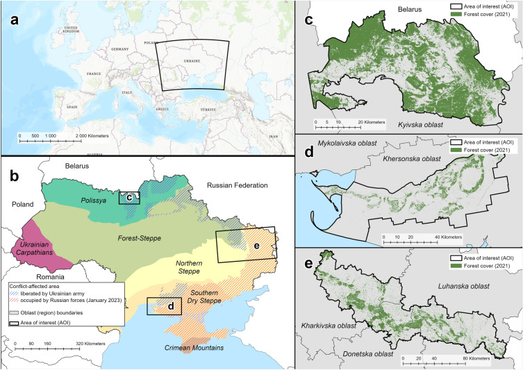
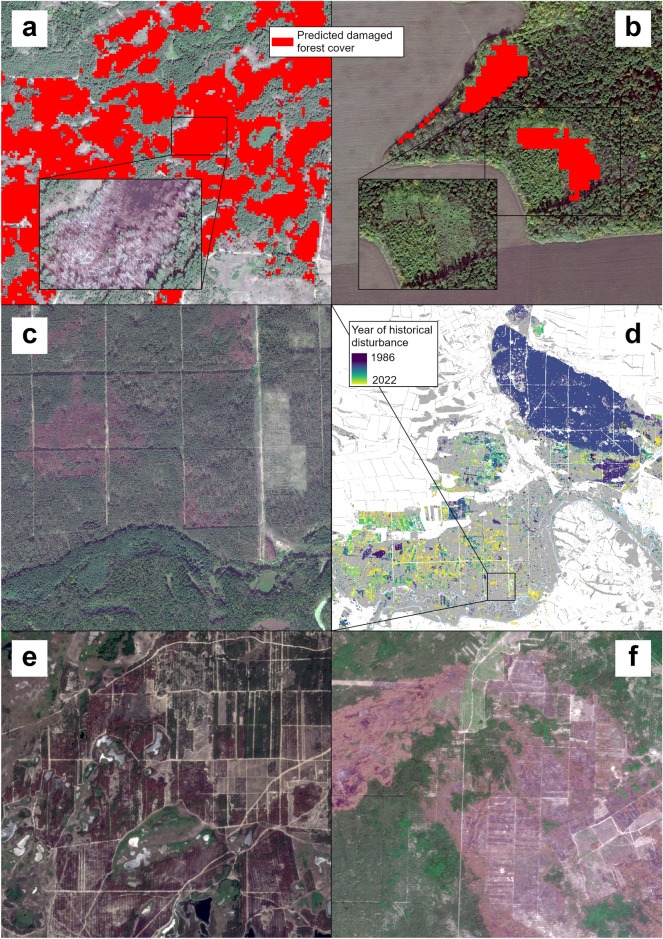
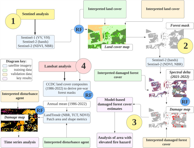
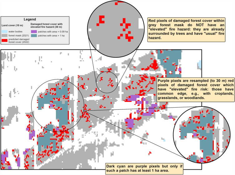
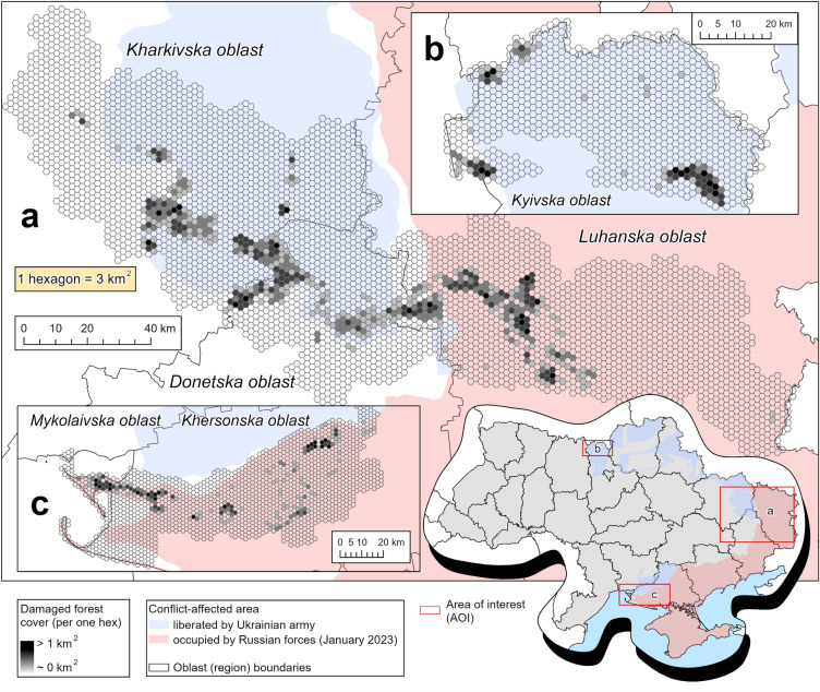
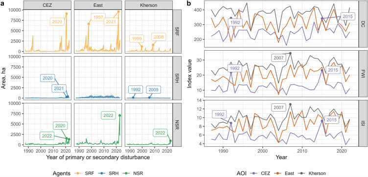
Since 24 February 2022, Ukraine has experienced full-scale military aggression initiated by the Russian Federation. The war has had a major negative impact on vegetation cover of war-affected regions. We explored interactions between pre-war forest management and the impacts of military activities in three of the most forested Ukrainian areas of interest (AOI), affected by the war. These were forests lying between Kharkiv and Luhansk cities (AOI 'East'), forests along the Dnipro River delta (AOI 'Kherson'), and those of the Chornobyl Exclusion Zone (AOI CEZ). We used Sentinel satellite imagery to create damaged forest cover masks for the year 2022. We mapped forests with elevated fire hazard, which was defined as a degree of exposure to the fire-supporting land use (mostly an agricultural land, a common source of ignitions in Ukraine). We evaluated the forest disturbance rate in 2022, as compared to pre-war rates. We documented significant increases in non-stand replacing disturbances (low severity fires and non-fire disturbances) for all three of the AOIs. Damaged forest cover varied among the AOIs (24,180 ± 4,715 ha, or 9.3% ± 1.8% in the 'East' AOI; 7,293 ± 1,925 ha, or 15.7% ± 4.1% in the 'Kherson' AOI; 7,116 ± 1,274 ha, or 5.0% ± 0.9% in the CEZ AOI). Among the forests damaged in 2022, the 'Kherson' AOI will likely have the highest proportion of an area with elevated fire hazard in the coming decades, as compared to other regions (89% vs. 70% in the 'East' and CEZ AOIs respectively). Future fire risks and extensive war-related disturbance of forest cover call for forest management to develop strategies explicitly addressing these factors.
自2022年2月24日以来,乌克兰经历了俄罗斯联邦发起的全面军事侵略。这场战争对战区的植被覆盖产生了重大负面影响。我们探讨了战前森林管理与军事活动对乌克兰三个受战争影响且森林覆盖率最高的感兴趣区域(AOI)的影响之间的相互作用。这三个区域分别是位于哈尔科夫市和卢甘斯克市之间的森林(AOI“东部”)、第聂伯河三角洲沿岸的森林(AOI“赫尔松”)以及切尔诺贝利禁区的森林(AOI CEZ)。我们利用哨兵卫星图像创建了2022年受损森林覆盖图。我们绘制了火灾风险较高的森林地图,火灾风险较高被定义为遭受有利于火灾发生的土地利用(主要是农业用地,这是乌克兰常见的火源)的程度。我们评估了2022年的森林干扰率,并与战前水平进行了比较。我们记录到,所有这三个AOI的非林分更替干扰(低强度火灾和非火灾干扰)均显著增加。受损森林覆盖面积在各AOI之间存在差异(“东部”AOI为24,180±4,715公顷,占9.3%±1.8%;“赫尔松”AOI为7,293±1,925公顷,占15.7%±4.1%;CEZ AOI为7,116±1,274公顷,占5.0%±0.9%)。在2022年受损的森林中,与其他地区相比,“赫尔松”AOI在未来几十年内火灾风险较高的区域所占比例可能最高(分别为89%,而“东部”AOI和CEZ AOI为70%)。未来的火灾风险以及与战争相关的森林覆盖大面积干扰,要求森林管理制定明确应对这些因素的策略。