Harisena Nivedita Varma, Grêt-Regamey Adrienne, Van Strien Maarten J
Planning of Landscape and Urban Systems PLUS, Department of Civil Environmental and Geomatic Engineering ETH Zurich Zurich Switzerland.
Ecol Evol. 2024 Aug 8;14(8):e70076. doi: 10.1002/ece3.70076. eCollection 2024 Aug.
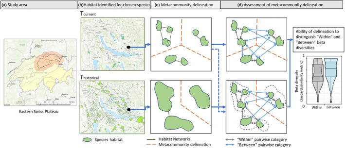
Although metacommunity theory provides many useful insights for conservation planning, the transfer of this knowledge to practice is hampered due to the difficulty of identifying metacommunities in bioregions. This study aims to identify the spatial extent of metacommunities at bioregional scales using current and historical habitat data, especially because contemporary biodiversity patterns may be a result of time-lagged responses to historical habitat configurations. Further, this estimation of the metacommunity spatial extent is based on both the habitat structure and the dispersal ability of the species. Focusing on dragonfly and damselfly (odonate) species in the eastern Swiss Plateau, the research uses wetland habitat information spanning over 110 years to create a time series of nine habitat networks between 1899 and 2010. From these networks, we identified the spatial extents of metacommunities based on the year of habitat information as well as on watershed boundaries. To identify the best metacommunity spatial extents, the study investigates whether patch pairs within a metacommunity exhibit greater similarity in species composition (i.e. lower beta-diversity) than patch pairs between metacommunities. For the different metacommunities, we further investigated correlations between gamma diversity and metacommunity size and compare them to theoretical expectations. In both analyses we found that augmenting spatial metacommunity identification with historical geographical proximity results in stronger associations with biodiversity patterns (beta and gamma diversity) than when using only current-day habitat or watershed information.
尽管集合群落理论为保护规划提供了许多有用的见解,但由于难以在生物区域中识别集合群落,这些知识向实践的转化受到了阻碍。本研究旨在利用当前和历史栖息地数据,确定生物区域尺度上集合群落的空间范围,特别是因为当代生物多样性模式可能是对历史栖息地配置的时间滞后响应的结果。此外,对集合群落空间范围的这种估计是基于栖息地结构和物种的扩散能力。以瑞士高原东部的蜻蜓目(蜻蜓和豆娘)物种为重点,该研究使用了跨越110多年的湿地栖息地信息,创建了1899年至2010年期间九个栖息地网络的时间序列。从这些网络中,我们根据栖息地信息年份以及流域边界确定了集合群落的空间范围。为了确定最佳的集合群落空间范围,该研究调查了集合群落内的斑块对在物种组成上是否比集合群落之间的斑块对表现出更大的相似性(即更低的β多样性)。对于不同的集合群落,我们进一步研究了γ多样性与集合群落大小之间的相关性,并将它们与理论预期进行比较。在这两项分析中,我们发现,与仅使用当前栖息地或流域信息相比,用历史地理邻近性增强空间集合群落识别,会导致与生物多样性模式(β和γ多样性)的关联更强。