Faculty of Geo-Information Science and Earth Observation, University of Twente, Enschede, The Netherlands.
Department of National Pak Monitoring and Animal Management, Bavarian Forest National Park, Grafenau, Germany.
Environ Monit Assess. 2024 Aug 26;196(9):841. doi: 10.1007/s10661-024-12993-5.
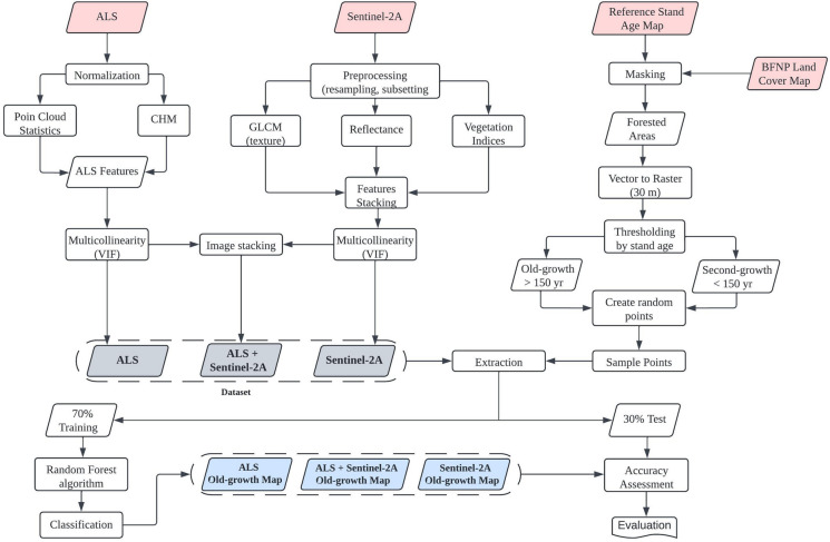
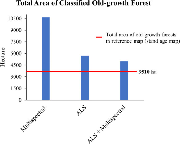
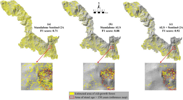
Old-growth forests are essential to preserve biodiversity and play an important role in sequestering carbon and mitigating climate change. However, their existence across Europe is vulnerable due to the scarcity of their distribution, logging, and environmental threats. Therefore, providing the current status of old-growth forests across Europe is essential to aiding informed conservation efforts and sustainable forest management. Remote sensing techniques have proven effective for mapping and monitoring forests over large areas. However, relying solely on remote sensing spectral or structural information cannot capture comprehensive horizontal and vertical structure complexity profiles associated with old-growth forest characteristics. To overcome this issue, we combined spectral information from Sentinel-2A multispectral imagery with 3D structural information from high-density point clouds of airborne laser scanning (ALS) imagery to map old-growth forests over an extended area. Four features from the ALS data and fifteen from Sentinel-2A comprising raw band (spectral reflectance), vegetation indices (VIs), and texture were selected to create three datasets used in the classification process using the random forest algorithm. The results demonstrated that combining ALS and Sentinel-2A features improved the classification performance and yielded the highest accuracy for old-growth class, with an F1-score of 92% and producer's and user's accuracies of 93% and 90%, respectively. The findings suggest that features from ALS and Sentinel-2A data sensitive to forest structure are essential for identifying old-growth forests. Integrating open-access satellite imageries, such as Sentinel-2A and ALS data, can benefit forest managers, stakeholders, and conservationists in monitoring old-growth forest preservation across a broader spatial extent.
古老的森林对于维护生物多样性至关重要,对于碳封存和缓解气候变化也起着重要作用。然而,由于其分布稀少、采伐和环境威胁,欧洲古老森林的存在正面临脆弱性挑战。因此,提供欧洲各地古老森林的现状对于支持有针对性的保护工作和可持续的森林管理至关重要。遥感技术已被证明在大面积森林测绘和监测方面非常有效。然而,仅依靠遥感光谱或结构信息无法捕捉到与古老森林特征相关的综合水平和垂直结构复杂性剖面。为了解决这个问题,我们将 Sentinel-2A 多光谱图像的光谱信息与机载激光扫描(ALS)图像的高密度点云的 3D 结构信息相结合,以绘制大面积的古老森林。我们从 ALS 数据中选择了四个特征,从 Sentinel-2A 中选择了 15 个特征,包括原始波段(光谱反射率)、植被指数(VIs)和纹理,用于使用随机森林算法进行分类过程。结果表明,结合 ALS 和 Sentinel-2A 特征可以提高分类性能,并获得最高的古老森林类别的准确性,F1 得分为 92%,生产者和使用者的准确率分别为 93%和 90%。研究结果表明,对森林结构敏感的 ALS 和 Sentinel-2A 特征对于识别古老森林至关重要。整合开放获取的卫星图像,如 Sentinel-2A 和 ALS 数据,可以使森林管理者、利益相关者和保护主义者受益,从而在更广泛的空间范围内监测古老森林的保护状况。