• 文献检索
  • 文档翻译
  • 深度研究
  • 学术资讯
  • Suppr Zotero 插件Zotero 插件
  • 邀请有礼
  • 套餐&价格
  • 历史记录
应用&插件
Suppr Zotero 插件Zotero 插件浏览器插件Mac 客户端Windows 客户端微信小程序
定价
高级版会员购买积分包购买API积分包
服务
文献检索文档翻译深度研究API 文档MCP 服务
关于我们
关于 Suppr公司介绍联系我们用户协议隐私条款
关注我们

Suppr 超能文献

核心技术专利:CN118964589B侵权必究
粤ICP备2023148730 号-1Suppr @ 2026

文献检索

告别复杂PubMed语法,用中文像聊天一样搜索,搜遍4000万医学文献。AI智能推荐,让科研检索更轻松。

立即免费搜索

文件翻译

保留排版,准确专业,支持PDF/Word/PPT等文件格式,支持 12+语言互译。

免费翻译文档

深度研究

AI帮你快速写综述,25分钟生成高质量综述,智能提取关键信息,辅助科研写作。

立即免费体验

利用深度学习对秘鲁高山遥感影像进行水体分割的探索性分析

Exploratory Analysis Using Deep Learning for Water-Body Segmentation of Peru's High-Mountain Remote Sensing Images.

作者信息

Perez-Torres William Isaac, Uman-Flores Diego Armando, Quispe-Quispe Andres Benjamin, Palomino-Quispe Facundo, Bezerra Emili, Leher Quefren, Paixão Thuanne, Alvarez Ana Beatriz

机构信息

LIECAR Laboratory, Universidad Nacional de San Antonio Abad del Cusco (UNSAAC), Cusco 08003, Peru.

PAVIC Laboratory, University of Acre (UFAC), Rio Branco 69915-900, Brazil.

出版信息

Sensors (Basel). 2024 Aug 10;24(16):5177. doi: 10.3390/s24165177.

DOI:10.3390/s24165177
PMID:39204871
原文链接:https://pmc.ncbi.nlm.nih.gov/articles/PMC11360623/
Abstract

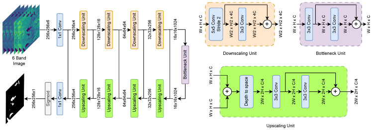
High-mountain water bodies represent critical components of their ecosystems, serving as vital freshwater reservoirs, environmental regulators, and sentinels of climate change. To understand the environmental dynamics of these regions, comprehensive analyses of lakes across spatial and temporal scales are necessary. While remote sensing offers a powerful tool for lake monitoring, applications in high-mountain terrain present unique challenges. The Ancash and Cuzco regions of the Peruvian Andes exemplify these challenges. These regions harbor numerous high-mountain lakes, which are crucial for fresh water supply and environmental regulation. This paper presents an exploratory examination of remote sensing techniques for lake monitoring in the Ancash and Cuzco regions of the Peruvian Andes. The study compares three deep learning models for lake segmentation: the well-established DeepWaterMapV2 and WatNet models and the adapted WaterSegDiff model, which is based on a combination of diffusion and transformation mechanisms specifically conditioned for lake segmentation. In addition, the Normalized Difference Water Index (NDWI) with Otsu thresholding is used for comparison purposes. To capture lakes across these regions, a new dataset was created with Landsat-8 multispectral imagery (bands 2-7) from 2013 to 2023. Quantitative and qualitative analyses were performed using metrics such as Mean Intersection over Union (MIoU), Pixel Accuracy (PA), and F1 Score. The results achieved indicate equivalent performance of DeepWaterMapV2 and WatNet encoder-decoder architectures, achieving adequate lake segmentation despite the challenging geographical and atmospheric conditions inherent in high-mountain environments. In the qualitative analysis, the behavior of the WaterSegDiff model was considered promising for the proposed application. Considering that WatNet is less computationally complex, with 3.4 million parameters, this architecture becomes the most pertinent to implement. Additionally, a detailed temporal analysis of Lake Singrenacocha in the Vilcanota Mountains was conducted, pointing out the more significant behavior of the WatNet model.

摘要

高山水体是其生态系统的关键组成部分,作为重要的淡水储备、环境调节器和气候变化的哨兵。为了解这些地区的环境动态,有必要在空间和时间尺度上对湖泊进行全面分析。虽然遥感为湖泊监测提供了强大的工具,但在高山地形中的应用面临独特挑战。秘鲁安第斯山脉的安卡什和库斯科地区就是这些挑战的例证。这些地区有众多高山湖泊,对淡水供应和环境调节至关重要。本文对秘鲁安第斯山脉安卡什和库斯科地区湖泊监测的遥感技术进行了探索性研究。该研究比较了三种用于湖泊分割的深度学习模型:成熟的DeepWaterMapV2和WatNet模型,以及基于扩散和变换机制组合专门为湖泊分割而调整的WaterSegDiff模型。此外,使用带大津阈值的归一化差异水指数(NDWI)进行比较。为了获取这些地区的湖泊信息,利用2013年至2023年的陆地卫星8号多光谱图像(波段2 - 7)创建了一个新数据集。使用平均交并比(MIoU)、像素精度(PA)和F1分数等指标进行了定量和定性分析。结果表明,DeepWaterMapV2和WatNet编码器 - 解码器架构具有同等性能,尽管高山环境存在具有挑战性的地理和大气条件,但仍能实现足够的湖泊分割。在定性分析中,WaterSegDiff模型的表现对于所提出的应用很有前景。考虑到WatNet的计算复杂度较低,有340万个参数,这种架构成为最适合实施的架构。此外,对维尔卡诺塔山脉的辛雷诺卡查湖进行了详细的时间分析,指出了WatNet模型更显著的表现。

https://cdn.ncbi.nlm.nih.gov/pmc/blobs/5405/11360623/6ababbcdcff9/sensors-24-05177-g013.jpg
https://cdn.ncbi.nlm.nih.gov/pmc/blobs/5405/11360623/e187745b71ea/sensors-24-05177-g001.jpg
https://cdn.ncbi.nlm.nih.gov/pmc/blobs/5405/11360623/f248f4224a93/sensors-24-05177-g002.jpg
https://cdn.ncbi.nlm.nih.gov/pmc/blobs/5405/11360623/0b3620acf125/sensors-24-05177-g003.jpg
https://cdn.ncbi.nlm.nih.gov/pmc/blobs/5405/11360623/e8a135957a04/sensors-24-05177-g004.jpg
https://cdn.ncbi.nlm.nih.gov/pmc/blobs/5405/11360623/9903d3590666/sensors-24-05177-g005.jpg
https://cdn.ncbi.nlm.nih.gov/pmc/blobs/5405/11360623/2b64865e1396/sensors-24-05177-g006.jpg
https://cdn.ncbi.nlm.nih.gov/pmc/blobs/5405/11360623/efa76a6be724/sensors-24-05177-g007.jpg
https://cdn.ncbi.nlm.nih.gov/pmc/blobs/5405/11360623/ea3d39b607b8/sensors-24-05177-g008.jpg
https://cdn.ncbi.nlm.nih.gov/pmc/blobs/5405/11360623/5668b544beda/sensors-24-05177-g009.jpg
https://cdn.ncbi.nlm.nih.gov/pmc/blobs/5405/11360623/b99d0652af90/sensors-24-05177-g010.jpg
https://cdn.ncbi.nlm.nih.gov/pmc/blobs/5405/11360623/de0adfdb840d/sensors-24-05177-g011.jpg
https://cdn.ncbi.nlm.nih.gov/pmc/blobs/5405/11360623/312290c4bae1/sensors-24-05177-g012.jpg
https://cdn.ncbi.nlm.nih.gov/pmc/blobs/5405/11360623/6ababbcdcff9/sensors-24-05177-g013.jpg

相似文献

1
Exploratory Analysis Using Deep Learning for Water-Body Segmentation of Peru's High-Mountain Remote Sensing Images.利用深度学习对秘鲁高山遥感影像进行水体分割的探索性分析
Sensors (Basel). 2024 Aug 10;24(16):5177. doi: 10.3390/s24165177.
2
Comparison of thresholding methods for shoreline extraction from Sentinel-2 and Landsat-8 imagery: Extreme Lake Salda, track of Mars on Earth.从 Sentinel-2 和 Landsat-8 影像中提取海岸线的阈值方法比较:极端盐湖萨尔达,火星在地球上的轨迹。
J Environ Manage. 2021 Nov 15;298:113481. doi: 10.1016/j.jenvman.2021.113481. Epub 2021 Aug 12.
3
Recent Surface Water Extent of Lake Chad from Multispectral Sensors and GRACE.乍得湖近期多光谱传感器和 GRACE 数据的地表水范围。
Sensors (Basel). 2018 Jun 28;18(7):2082. doi: 10.3390/s18072082.
4
A review on the research progress of lake water volume estimation methods.湖泊水量估算方法研究进展综述
J Environ Manage. 2022 Jul 15;314:115057. doi: 10.1016/j.jenvman.2022.115057. Epub 2022 Apr 19.
5
Glacial Lake Area Changes in High Mountain Asia during 1990-2020 Using Satellite Remote Sensing.利用卫星遥感技术对1990 - 2020年亚洲高山地区冰川湖面积变化的研究
Research (Wash D C). 2022 Oct 21;2022:9821275. doi: 10.34133/2022/9821275. eCollection 2022.
6
Potential impact of flooding on schistosomiasis in Poyang Lake regions based on multi-source remote sensing images.基于多源遥感图像的鄱阳湖地区洪水对血吸虫病的潜在影响。
Parasit Vectors. 2021 Feb 22;14(1):116. doi: 10.1186/s13071-021-04576-x.
7
Estimation of dissolved organic carbon from inland waters at a large scale using satellite data and machine learning methods.利用卫星数据和机器学习方法大规模估算内陆水体中的溶解有机碳。
Water Res. 2023 Feb 1;229:119478. doi: 10.1016/j.watres.2022.119478. Epub 2022 Dec 9.
8
Remote sensing and monitoring of water resources: A comparative study of different indices and thresholding methods.水资源的遥感与监测:不同指标及阈值方法的比较研究
Sci Total Environ. 2024 May 20;926:172117. doi: 10.1016/j.scitotenv.2024.172117. Epub 2024 Mar 31.
9
Integrated satellite data fusion and mining for monitoring lake water quality status of the Albufera de Valencia in Spain.用于监测西班牙巴伦西亚阿尔布费拉湖水质状况的综合卫星数据融合与挖掘
J Environ Manage. 2015 Mar 15;151:416-26. doi: 10.1016/j.jenvman.2014.12.003. Epub 2015 Jan 17.
10
[Research Progress on Remote Sensing Monitoring of Lake Water Quality Parameters].湖泊水质参数遥感监测研究进展
Huan Jing Ke Xue. 2023 Mar 8;44(3):1228-1243. doi: 10.13227/j.hjkx.202203285.

引用本文的文献

1
Water Body Extraction Methods for SAR Images Fusing Sentinel-1 Dual-Polarized Water Index and Random Forest.融合哨兵-1双极化水体指数和随机森林的合成孔径雷达图像水体提取方法
Sensors (Basel). 2025 Aug 7;25(15):4868. doi: 10.3390/s25154868.

本文引用的文献

1
Image Super-Resolution via Iterative Refinement.通过迭代细化实现图像超分辨率
IEEE Trans Pattern Anal Mach Intell. 2023 Apr;45(4):4713-4726. doi: 10.1109/TPAMI.2022.3204461. Epub 2023 Mar 7.
2
Impact of deep learning architectures on accelerated cardiac T mapping using MyoMapNet.基于 MyoMapNet 的深度学习架构对加速心脏 T 映射的影响。
NMR Biomed. 2022 Nov;35(11):e4794. doi: 10.1002/nbm.4794. Epub 2022 Jul 14.
3
Improved Support Vector Machine Enabled Radial Basis Function and Linear Variants for Remote Sensing Image Classification.
改进的支持向量机支持的径向基函数和线性变体在遥感图像分类中的应用。
Sensors (Basel). 2021 Jun 28;21(13):4431. doi: 10.3390/s21134431.
4
DeepLab: Semantic Image Segmentation with Deep Convolutional Nets, Atrous Convolution, and Fully Connected CRFs.DeepLab:基于深度卷积网络、空洞卷积和全连接条件随机场的语义图像分割。
IEEE Trans Pattern Anal Mach Intell. 2018 Apr;40(4):834-848. doi: 10.1109/TPAMI.2017.2699184. Epub 2017 Apr 27.
5
A computational approach to edge detection.一种基于计算的边缘检测方法。
IEEE Trans Pattern Anal Mach Intell. 1986 Jun;8(6):679-98.
6
Lakes as sentinels of climate change.湖泊作为气候变化的哨兵。
Limnol Oceanogr. 2009 Nov;54(6):2283-2297. doi: 10.4319/lo.2009.54.6_part_2.2283.