• 文献检索
  • 文档翻译
  • 深度研究
  • 学术资讯
  • Suppr Zotero 插件Zotero 插件
  • 邀请有礼
  • 套餐&价格
  • 历史记录
应用&插件
Suppr Zotero 插件Zotero 插件浏览器插件Mac 客户端Windows 客户端微信小程序
定价
高级版会员购买积分包购买API积分包
服务
文献检索文档翻译深度研究API 文档MCP 服务
关于我们
关于 Suppr公司介绍联系我们用户协议隐私条款
关注我们

Suppr 超能文献

核心技术专利:CN118964589B侵权必究
粤ICP备2023148730 号-1Suppr @ 2026

文献检索

告别复杂PubMed语法,用中文像聊天一样搜索,搜遍4000万医学文献。AI智能推荐,让科研检索更轻松。

立即免费搜索

文件翻译

保留排版,准确专业,支持PDF/Word/PPT等文件格式,支持 12+语言互译。

免费翻译文档

深度研究

AI帮你快速写综述,25分钟生成高质量综述,智能提取关键信息,辅助科研写作。

立即免费体验

利用综合地质和地球物理技术对埃及穆卡塔姆高原的旋转滑坡进行调查与监测。

Investigation and monitoring of rotational landslides in El Mokkattam plateau Egypt, using integrated geological and geophysical techniques.

作者信息

Gamal Mohamed A, Abdelfattah Mohamed, Maher George

机构信息

Geophysics Department, Faculty of Science, Cairo University, Giza, Egypt.

Geology Department, Faculty of Science, Beni-Suef University, Beni-Suef, Egypt.

出版信息

Heliyon. 2024 Aug 22;10(17):e36545. doi: 10.1016/j.heliyon.2024.e36545. eCollection 2024 Sep 15.

DOI:10.1016/j.heliyon.2024.e36545
PMID:39286139
原文链接:https://pmc.ncbi.nlm.nih.gov/articles/PMC11403509/
Abstract

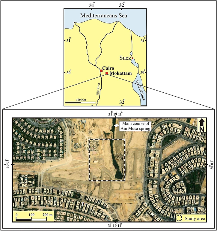
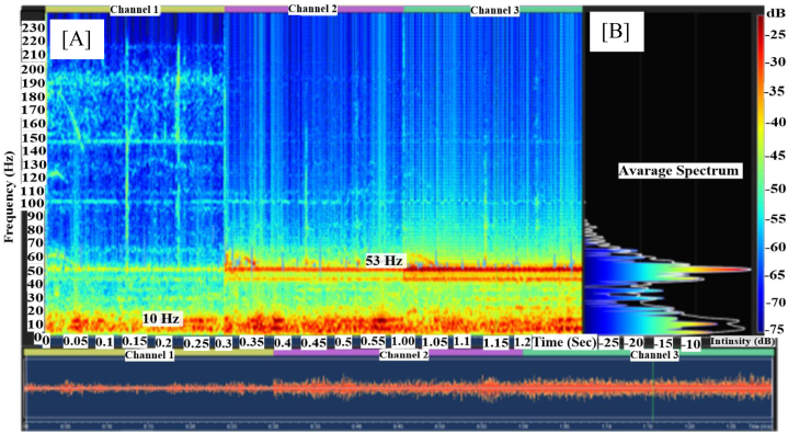
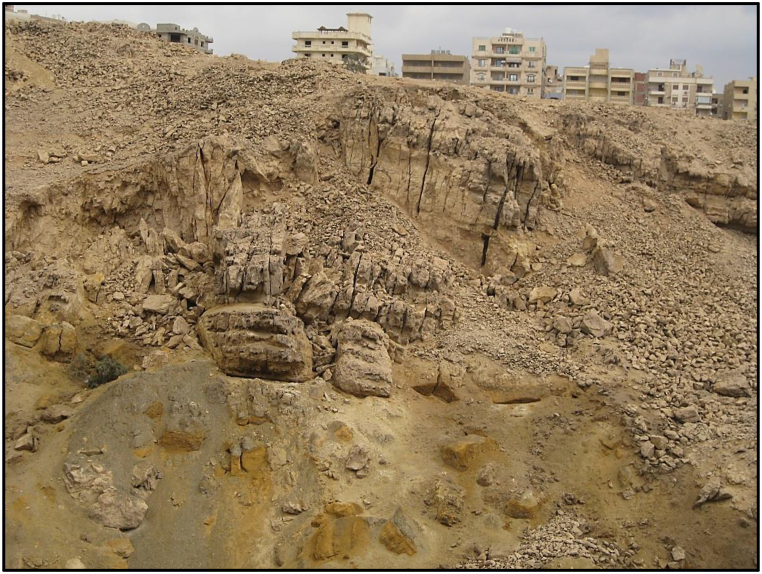
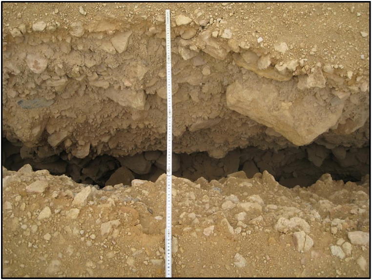
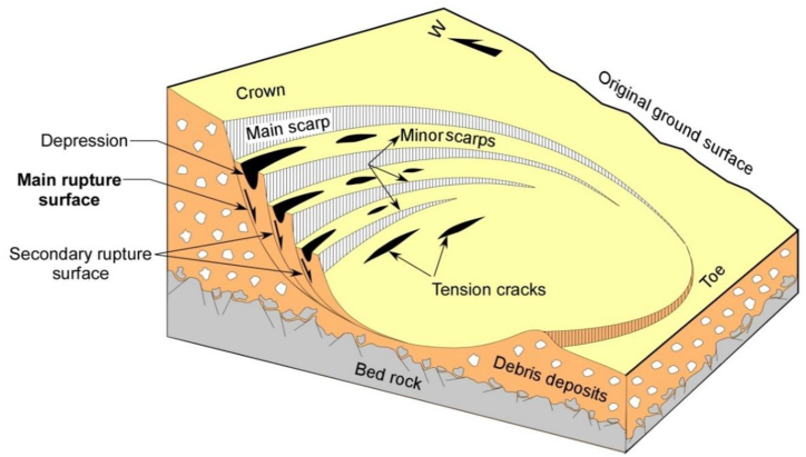
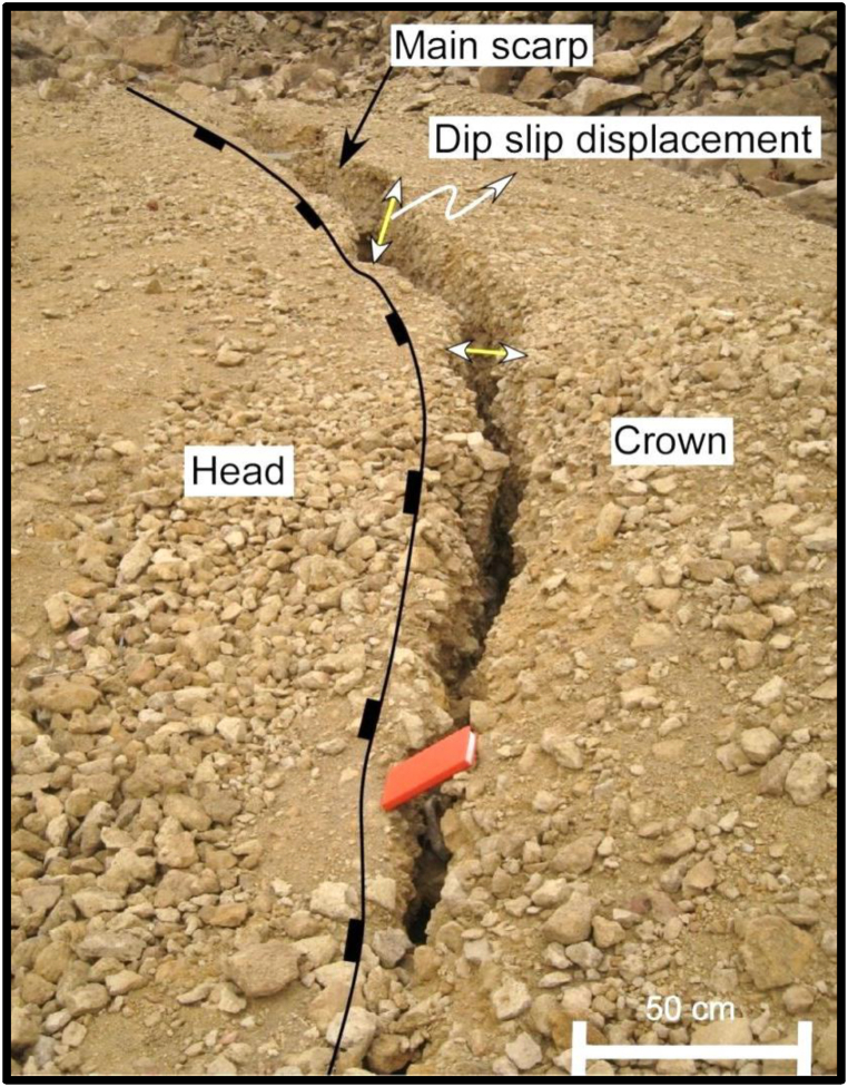
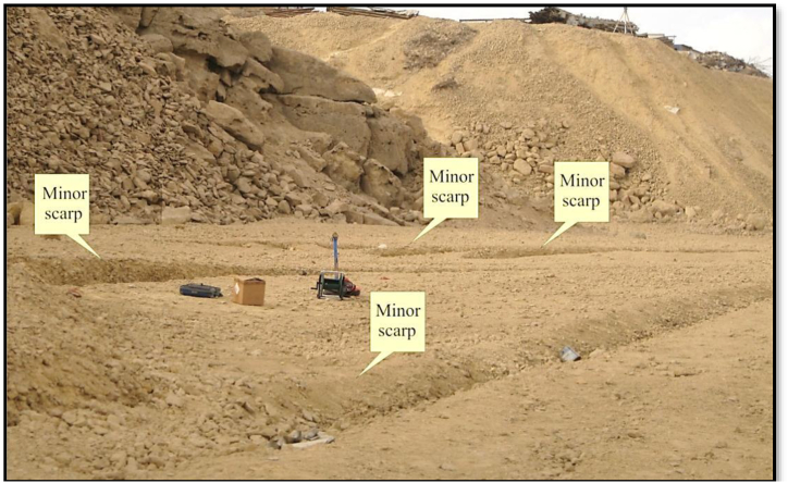
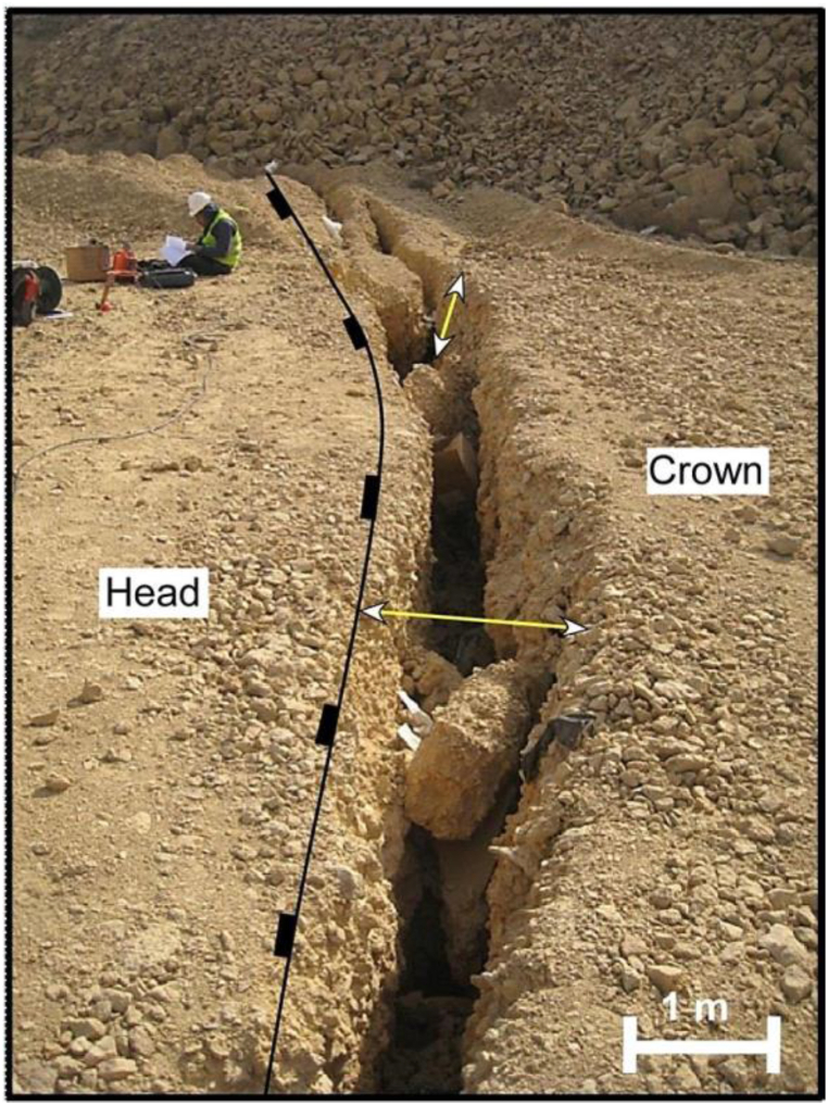
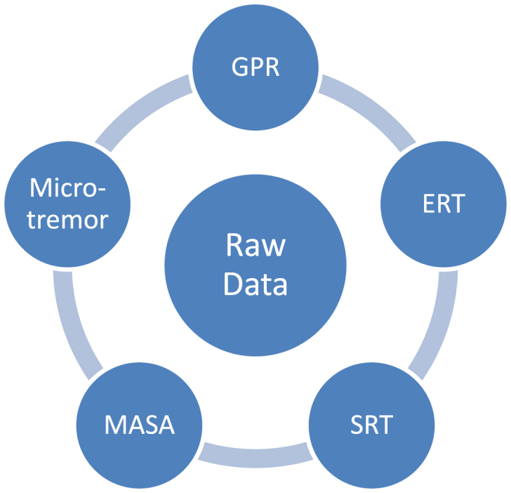
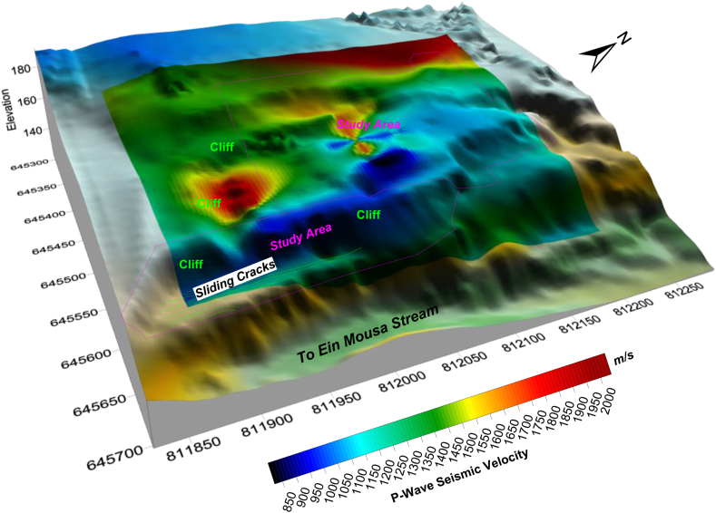
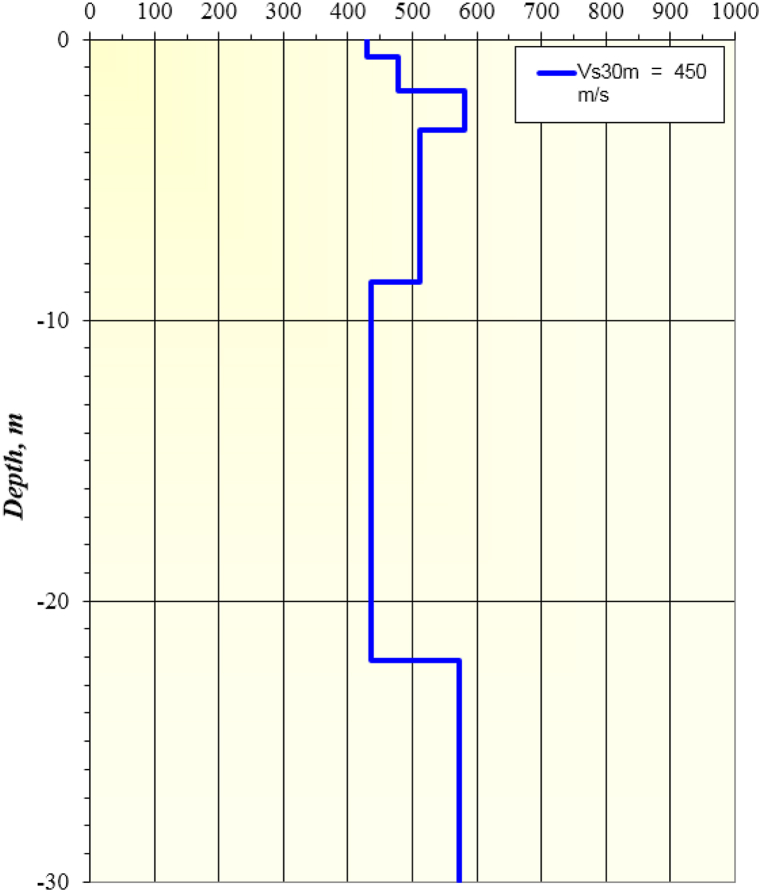
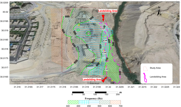
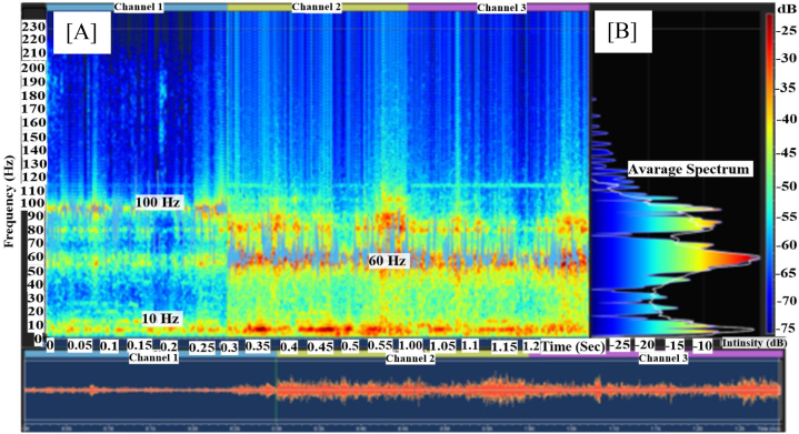
Landslides are a rare but hazardous geological phenomenon in Egypt, with the El Mokattam plateau situated in the eastern part of Cairo covering approximately 64 km and ranging in elevation from 50 to 205 m. This study aims to identify and monitor landslides in the area using various geophysical methods. Twelve Electrical resistivity tomography (ERT) profiles,twenty-two P-wave Seismic Refraction profiles, twenty-two Refraction microtremors profiles, three ground penetrating radar (GPR) profiles and borehole data were utilized to analyze the occurrence of landslides in the El Mokattam Plateau. Additionally, we employed a relatively new geophysical method, studying high-frequency microtremor sounds emitted from landslide collapses at 22 stations. Our analysis identified steep slopes, jointed or fractured rocks, and irrigation water as primary factors contributing to landslides, with irrigation water acting as a lubricant for clays and promoting ground sliding. Examination of high-frequency microtremor sounds revealed a potential correlation between vertical high-frequency spectra at 100 Hz and landslide collapses, which aids in the identification of landslide-prone zones. Therefore, we conclude that seismological studies, particularly spectral analysis of high-frequency and low-amplitude sounds (microtremors) emitted from soil, offer a promising approach for investigating landslides.

摘要

山体滑坡在埃及是一种罕见但危险的地质现象,位于开罗东部的穆卡塔姆高原面积约64平方公里,海拔50至205米。本研究旨在运用多种地球物理方法识别和监测该地区的山体滑坡。利用12条电阻率层析成像(ERT)剖面、22条P波地震折射剖面、22条微震折射剖面、3条探地雷达(GPR)剖面以及钻孔数据,分析穆卡塔姆高原山体滑坡的发生情况。此外,我们采用了一种相对较新的地球物理方法,在22个站点研究山体滑坡崩塌产生的高频微震声音。我们的分析确定了陡坡、节理或破碎岩石以及灌溉用水是导致山体滑坡的主要因素,灌溉用水起到了润滑黏土并促使地面滑动的作用。对高频微震声音的检测揭示了100赫兹处的垂直高频频谱与山体滑坡崩塌之间存在潜在关联,这有助于识别易发生山体滑坡的区域。因此,我们得出结论,地震学研究,特别是对土壤发出的高频和低振幅声音(微震)进行频谱分析,为调查山体滑坡提供了一种很有前景的方法。

https://cdn.ncbi.nlm.nih.gov/pmc/blobs/3e81/11403509/52c884b7ce3a/gr35.jpg
https://cdn.ncbi.nlm.nih.gov/pmc/blobs/3e81/11403509/e97f1aba5060/gr1.jpg
https://cdn.ncbi.nlm.nih.gov/pmc/blobs/3e81/11403509/2f941ee08862/gr2.jpg
https://cdn.ncbi.nlm.nih.gov/pmc/blobs/3e81/11403509/cf55c44d1f18/gr3.jpg
https://cdn.ncbi.nlm.nih.gov/pmc/blobs/3e81/11403509/6d81e3741416/gr4.jpg
https://cdn.ncbi.nlm.nih.gov/pmc/blobs/3e81/11403509/1b7ed5c46293/gr5.jpg
https://cdn.ncbi.nlm.nih.gov/pmc/blobs/3e81/11403509/0af083faf4d5/gr6.jpg
https://cdn.ncbi.nlm.nih.gov/pmc/blobs/3e81/11403509/47ee3783945c/gr7.jpg
https://cdn.ncbi.nlm.nih.gov/pmc/blobs/3e81/11403509/85496539acc5/gr9.jpg
https://cdn.ncbi.nlm.nih.gov/pmc/blobs/3e81/11403509/58e5a2350689/gr11.jpg
https://cdn.ncbi.nlm.nih.gov/pmc/blobs/3e81/11403509/d66cf725c5be/gr15.jpg
https://cdn.ncbi.nlm.nih.gov/pmc/blobs/3e81/11403509/cc6a726ef717/gr28.jpg
https://cdn.ncbi.nlm.nih.gov/pmc/blobs/3e81/11403509/a3bd8e576a24/gr30.jpg
https://cdn.ncbi.nlm.nih.gov/pmc/blobs/3e81/11403509/f55b6fbef24d/gr32.jpg
https://cdn.ncbi.nlm.nih.gov/pmc/blobs/3e81/11403509/ea59a80f16a1/gr34.jpg
https://cdn.ncbi.nlm.nih.gov/pmc/blobs/3e81/11403509/52c884b7ce3a/gr35.jpg

相似文献

1
Investigation and monitoring of rotational landslides in El Mokkattam plateau Egypt, using integrated geological and geophysical techniques.利用综合地质和地球物理技术对埃及穆卡塔姆高原的旋转滑坡进行调查与监测。
Heliyon. 2024 Aug 22;10(17):e36545. doi: 10.1016/j.heliyon.2024.e36545. eCollection 2024 Sep 15.
2
Landslide assessment through integrated geoelectrical and seismic methods: A case study in Thungsong site, southern Thailand.通过综合地电和地震方法进行滑坡评估:以泰国南部通宋地区为例
Heliyon. 2024 Jan 13;10(2):e24660. doi: 10.1016/j.heliyon.2024.e24660. eCollection 2024 Jan 30.
3
An integrated geotechnical and geophysical investigation of landslide in Chira town, Ethiopia.埃塞俄比亚奇拉镇滑坡的岩土工程与地球物理综合调查。
Heliyon. 2023 Jun 24;9(7):e17620. doi: 10.1016/j.heliyon.2023.e17620. eCollection 2023 Jul.
4
Investigation of landslide potential parameters on Zonguldak-Ereğli Highway and adverse effects of landslides in the region.宗古尔达克-埃雷利高速公路滑坡潜在参数的研究及该地区滑坡的不利影响。
Environ Monit Assess. 2014 Apr;186(4):2435-47. doi: 10.1007/s10661-013-3550-3. Epub 2013 Dec 14.
5
Combining geophysical prospection and core drilling: Reconstruction of a Late Bronze Age copper mine at Prigglitz-Gasteil in the Eastern Alps (Austria).结合地球物理勘探与岩芯钻探:重建奥地利东部阿尔卑斯山普里格利茨 - 加施泰尔的一座青铜时代晚期铜矿。
Archaeol Prospect. 2022 Oct-Dec;29(4):557-577. doi: 10.1002/arp.1872. Epub 2022 Aug 2.
6
Analysis of the spatial distribution of the landslides triggered by the 1923 Great Kanto Earthquake, Japan.分析 1923 年日本关东大地震引发的滑坡的空间分布。
Proc Jpn Acad Ser B Phys Biol Sci. 2024 Feb 9;100(2):123-139. doi: 10.2183/pjab.100.009. Epub 2023 Dec 29.
7
Detection and analysis of potential landslides based on SBAS-InSAR technology in alpine canyon region.基于SBAS-InSAR技术的高山峡谷地区潜在滑坡检测与分析
Environ Sci Pollut Res Int. 2024 Jan;31(4):6492-6510. doi: 10.1007/s11356-023-31473-w. Epub 2023 Dec 27.
8
Characteristics and mechanisms of large-scale old landslides and landslide dams in the Loess Plateau-A case study from Daning County, Shanxi Province, China.黄土高原大型古滑坡及滑坡坝的特征与机制——以中国山西省大宁县为例
Heliyon. 2023 Sep 6;9(9):e19910. doi: 10.1016/j.heliyon.2023.e19910. eCollection 2023 Sep.
9
Geophysical Assessment of a Proposed Landfill Site in Fredericktown, Missouri.密苏里州弗雷德里克敦一个拟议垃圾填埋场场地的地球物理评估。
FastTIMES. 2020 Aug 24;25(2):98-106. doi: 10.4133/sageep.32-031.
10
Exploitation of optical and SAR amplitude imagery for landslide identification: a case study from Sikkim, Northeast India.利用光学和 SAR 幅度图像进行滑坡识别:来自印度东北部锡金邦的案例研究。
Environ Monit Assess. 2021 Jun 5;193(7):386. doi: 10.1007/s10661-021-09119-6.

本文引用的文献

1
Application of electrical resistivity tomography (ERT) for rock mass quality evaluation.电阻率层析成像(ERT)在岩体质量评价中的应用。
Sci Rep. 2021 Dec 8;11(1):23683. doi: 10.1038/s41598-021-03217-8.
2
Parental efficacy, self-control, and delinquency: A test of a general theory of crime on a nationally representative sample of youth.父母效能、自我控制与犯罪:对一个全国代表性青少年样本进行的犯罪一般理论检验。
Int J Offender Ther Comp Criminol. 2004 Jun;48(3):298-312. doi: 10.1177/0306624X03262513.