Acharya Bipin Kumar, Sharma Shristi, Khanal Laxman, Joshi Pramod, Dhimal Meghnath
Planetary Health Research Centre, Kathmandu, Nepal.
Nepal Geographical Society, Kathmandu, Nepal.
Trop Med Health. 2025 Aug 19;53(1):111. doi: 10.1186/s41182-025-00741-5.
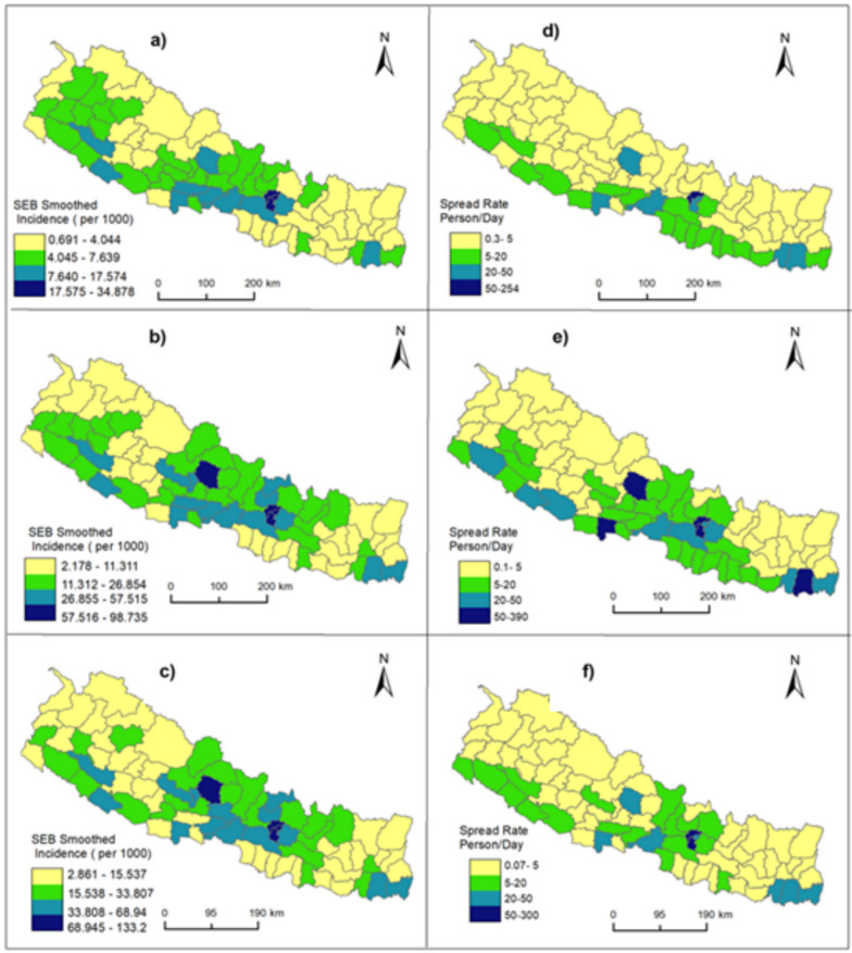
COVID-19 has been a major global health concern, severely impacting Nepal with thousands of cases and deaths. The patterns of COVID-19 incidence in the country may have varied over time during the pandemic, with geographic factors playing different roles in the early, middle, and later phases of transmission.
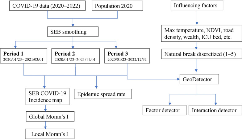
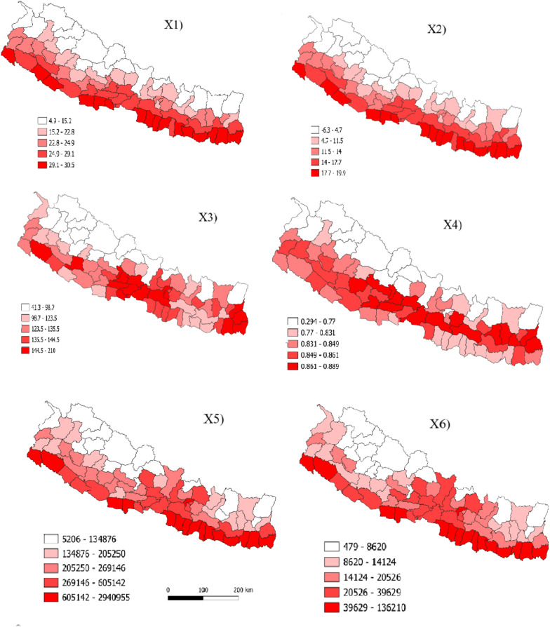
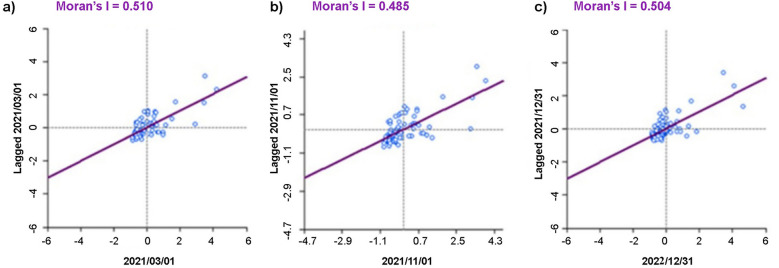
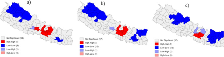
We utilized spatial statistics and GeoDetector methods to analyze district-level variations in COVID-19 incidence across Nepal from January 2020 to December 2022 using laboratory confirmed cases of the disease and a range of physical, biological and socioenvironmental explanatory variables. The analysis focused on identifying spatial patterns, hotspots, and key driving factors contributing to the uneven distribution of COVID-19 cases.
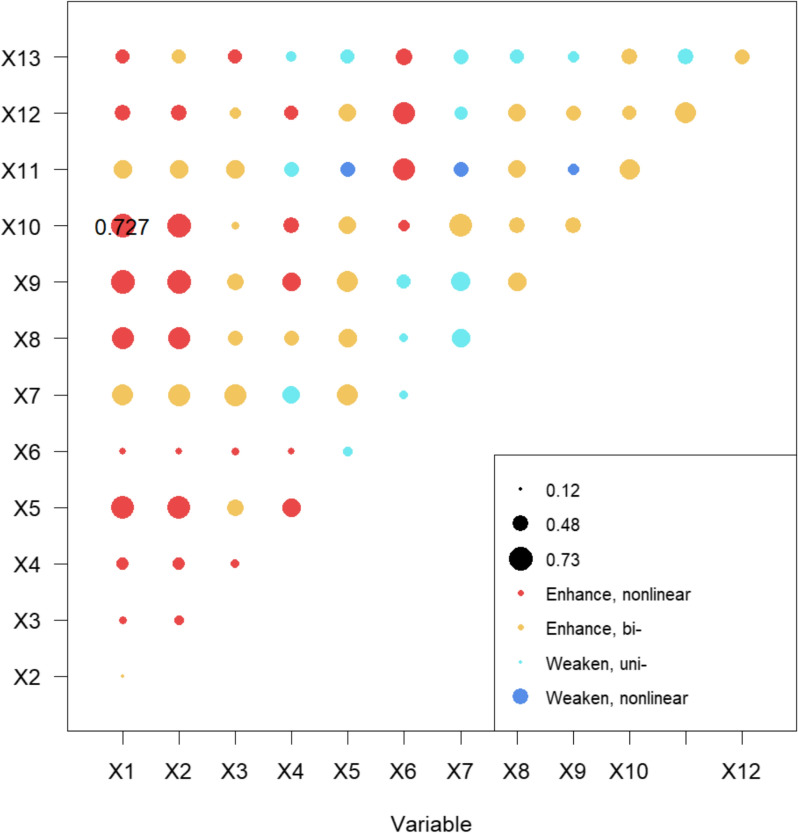
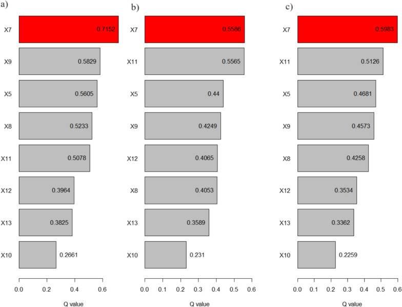
We found an uneven distribution of COVID-19 in Nepal, with persistent hotspots in major cities, such as Kathmandu and Pokhara, reaching up to 133 cases per 1000 population. GeoDetector analysis identified the key drivers, including road density (q = 0.59, p < 0.001), ICU bed distribution (q = 0.51, p < 0.001), and population density (q = 0.46, p < 0.001). While natural environmental factors such as temperature, precipitation, and NDVI had low and statistically insignificant independent explanatory power, their interaction with variables such as nighttime light, NDVI, and population density enhanced explanatory strength, highlighting the complex spatial distribution of COVID-19 incidence.
We recommend that the Nepalese government implement more targeted and region-specific interventions to address COVID-19 outbreaks, especially in persistent hotspot areas, such as Kathmandu and other emerging cities.
新冠疫情一直是全球主要的健康问题,给尼泊尔带来了严重影响,导致数千人感染和死亡。在疫情期间,该国新冠发病率模式可能随时间变化,地理因素在传播的早期、中期和后期发挥了不同作用。
我们利用空间统计和地理探测器方法,使用该疾病的实验室确诊病例以及一系列自然、生物和社会环境解释变量,分析了2020年1月至2022年12月尼泊尔各地区新冠发病率的差异。该分析重点在于识别空间模式、热点地区以及导致新冠病例分布不均的关键驱动因素。
我们发现尼泊尔新冠疫情分布不均,加德满都和博卡拉等主要城市存在持续的热点地区,每千人口发病率高达133例。地理探测器分析确定了关键驱动因素,包括道路密度(q = 0.59,p < 0.001)、重症监护病床分布(q = 0.51,p < 0.001)和人口密度(q = 0.46,p < 0.001)。虽然温度、降水和归一化植被指数等自然环境因素的独立解释力较低且无统计学意义,但其与夜间灯光亮度、归一化植被指数和人口密度等变量的相互作用增强了解释力,凸显了新冠发病率复杂的空间分布。
我们建议尼泊尔政府实施更具针对性和地区特异性的干预措施,以应对新冠疫情爆发,特别是在加德满都和其他新兴城市等持续的热点地区。