Qonono Kwanele, Lunga Wilfred
Department of Geography and Environmental Studies, Centre for Regional and Urban Innovation and Statistical Exploration (CRUISE), Faculty of Arts and Social Sciences, Stellenbosch University, Stellenbosch, South Africa.
Research Impact Division, Impact and Evaluation Unit, Human Sciences Research Council, Cape Town, South Africa.
Jamba. 2025 Aug 29;17(1):1898. doi: 10.4102/jamba.v17i1.1898. eCollection 2025.
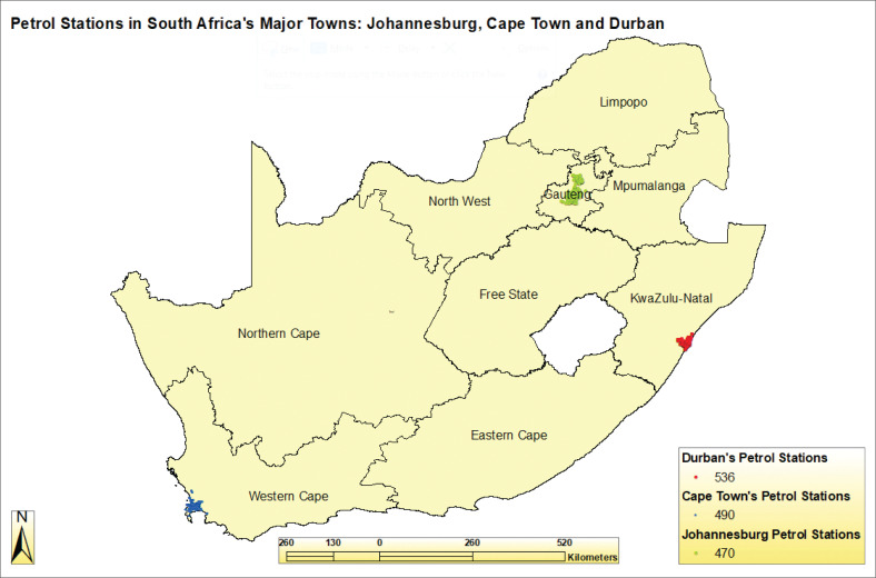
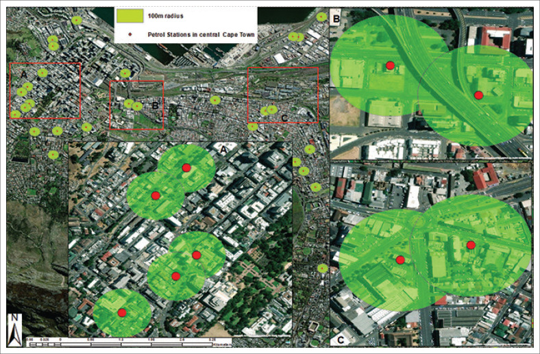
Noncompliance with locational guidelines for petrol station facilities in South Africa's urban areas is widespread, posing significant disaster risks. Petrol stations store and handle flammable substances such as liquefied petroleum gas, hydrogen and biodiesel, making adherence to environmental impact assessment (EIA) safety parameters critical. This study evaluates the spatial distribution and compliance of petrol stations in Johannesburg, Cape Town and Durban with the 2002 EIA guidelines. Using a mixed-methods approach, geospatial mapping via Google Earth and ArcGIS alongside secondary qualitative analysis, the study assessed petrol station distances from sensitive land uses (residential, public institutions and critical infrastructure) and the spacing between petrol stations. The results reveal a significant degree of noncompliance with the EIA's 100-m setback from sensitive uses and the 3-km minimum distance between petrol stations. In all three cities, petrol stations are often clustered within high-density urban cores, overlapping safety buffer zones and situated near residential and institutional structures. These spatial patterns indicate a regulatory gap in land-use enforcement and raise serious concerns about disaster preparedness and risk exposure in urban areas. The findings emphasise the urgent need to integrate disaster risk reduction (DRR) into urban land-use planning. While the study acknowledges that existing noncompliant petrol stations cannot be retrofitted easily, it recommends embedding DRR into future siting policies and calls for emergency preparedness measures at high-risk sites.
The study's spatially grounded analysis of EIA compliance across multiple cities in South Africa offers an evidence-based framework to guide future policy on hazardous facility siting in disaster-prone urban contexts.
南非城市地区加油站设施不符合选址指南的情况普遍存在,带来重大灾害风险。加油站储存和处理液化石油气、氢气和生物柴油等易燃物质,因此遵守环境影响评估(EIA)安全参数至关重要。本研究评估了约翰内斯堡、开普敦和德班的加油站在空间分布上是否符合2002年EIA指南。该研究采用混合方法,通过谷歌地球和ArcGIS进行地理空间绘图,并辅以定性分析,评估了加油站与敏感土地用途(住宅、公共机构和关键基础设施)之间的距离以及加油站之间的间距。结果显示,在很大程度上不符合EIA规定的与敏感用途保持100米的退缩距离以及加油站之间至少3公里的距离要求。在所有这三个城市中,加油站往往聚集在高密度城市核心区域内,安全缓冲区相互重叠,且位于住宅和机构建筑附近。这些空间格局表明在土地使用执法方面存在监管漏洞,并引发了对城市地区灾害准备和风险暴露的严重担忧。研究结果强调迫切需要将减少灾害风险(DRR)纳入城市土地利用规划。虽然该研究承认现有的不符合规定的加油站难以轻易改造,但建议将DRR纳入未来的选址政策,并呼吁在高风险地点采取应急准备措施。
该研究对南非多个城市的EIA合规情况进行基于空间的分析,提供了一个循证框架,以指导未来在易受灾城市环境中危险设施选址的政策。