Shuai Jiangping, Buck Peter, Sockett Paul, Aramini Jeff, Pollari Frank
Foodborne, Waterborne and Zoonotic Infections Division, Centre for Infectious Disease Prevention and Control, Public Health Agency of Canada, Tunney's Pasture, Ottawa, Canada.
Int J Health Geogr. 2006 Apr 20;5:17. doi: 10.1186/1476-072X-5-17.
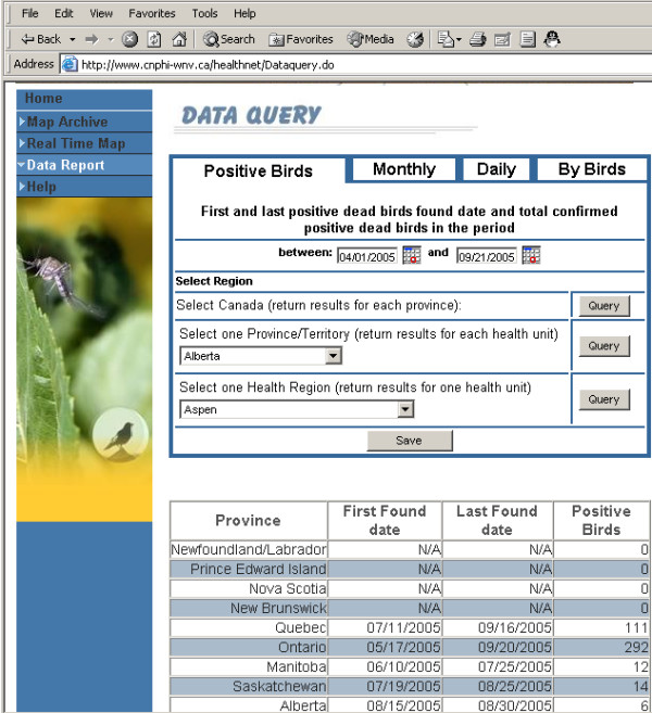
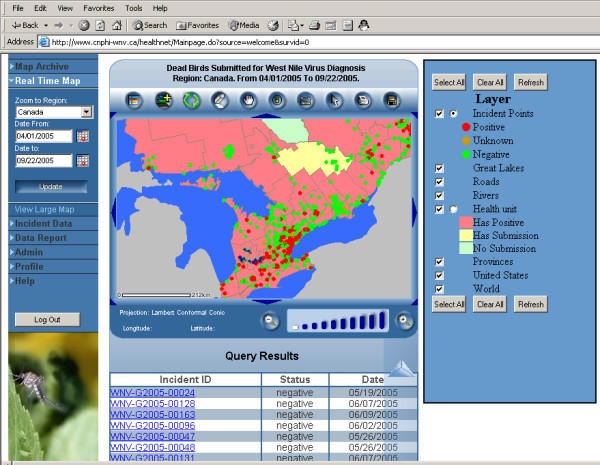
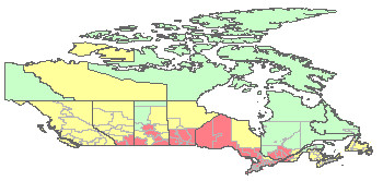
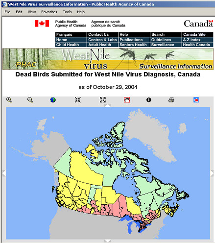
An extensive West Nile virus surveillance program of dead birds, mosquitoes, horses, and human infection has been launched as a result of West Nile virus first being reported in Canada in 2001. Some desktop and web GIS have been applied to West Nile virus dead bird surveillance. There have been urgent needs for a comprehensive GIS services and real-time surveillance.
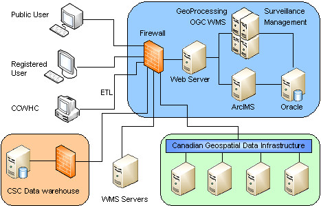
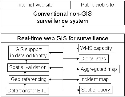
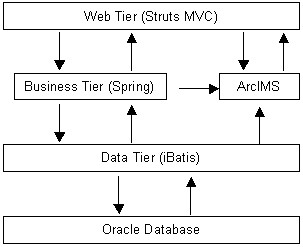
A pilot system was developed to integrate real-time surveillance, real-time GIS, and Open GIS technology in order to enhance West Nile virus dead bird surveillance in Canada. Driven and linked by the newly developed real-time web GIS technology, this integrated real-time surveillance system includes conventional real-time web-based surveillance components, integrated real-time GIS components, and integrated Open GIS components. The pilot system identified the major GIS functions and capacities that may be important to public health surveillance. The six web GIS clients provide a wide range of GIS tools for public health surveillance. The pilot system has been serving Canadian national West Nile virus dead bird surveillance since 2005 and is adaptable to serve other disease surveillance.
This pilot system has streamlined, enriched and enhanced national West Nile virus dead bird surveillance in Canada, improved productivity, and reduced operation cost. Its real-time GIS technology, static map technology, WMS integration, and its integration with non-GIS real-time surveillance system made this pilot system unique in surveillance and public health GIS.
由于2001年西尼罗河病毒首次在加拿大被报告,因此启动了一项针对死鸟、蚊子、马匹和人类感染的广泛西尼罗河病毒监测计划。一些桌面和网络地理信息系统(GIS)已应用于西尼罗河病毒死鸟监测。人们迫切需要全面的GIS服务和实时监测。
开发了一个试点系统,以整合实时监测、实时GIS和开放式GIS技术,以加强加拿大西尼罗河病毒死鸟监测。在新开发的实时网络GIS技术的驱动和连接下,这个集成的实时监测系统包括传统的基于网络的实时监测组件、集成的实时GIS组件和集成的开放式GIS组件。该试点系统确定了对公共卫生监测可能重要的主要GIS功能和能力。六个网络GIS客户端为公共卫生监测提供了广泛的GIS工具。该试点系统自2005年以来一直在为加拿大全国西尼罗河病毒死鸟监测服务,并且适用于其他疾病监测。
该试点系统简化、丰富并加强了加拿大全国西尼罗河病毒死鸟监测,提高了生产力,降低了运营成本。其实时GIS技术、静态地图技术、网络地图服务(WMS)集成以及与非GIS实时监测系统的集成使该试点系统在监测和公共卫生GIS方面独具特色。