Department of Earth Sciences, University of Memphis, Memphis, TN 38152, USA.
Int J Environ Res Public Health. 2013 Oct 25;10(11):5399-432. doi: 10.3390/ijerph10115399.
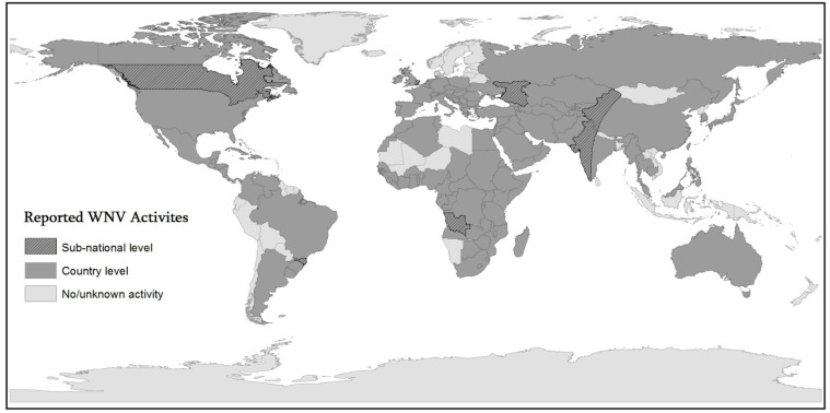
Over the last two decades West Nile Virus (WNV) has been responsible for significant disease outbreaks in humans and animals in many parts of the World. Its extremely rapid global diffusion argues for a better understanding of its geographic extent. The purpose of this inquiry was to explore spatio-temporal patterns of WNV using geospatial technologies to study populations of the reservoir hosts, vectors, and human hosts, in addition to the spatio-temporal interactions among these populations. Review of the recent literature on spatial WNV disease risk modeling led to the conclusion that numerous environmental factors might be critical for its dissemination. New Geographic Information Systems (GIS)-based studies are monitoring occurrence at the macro-level, and helping pinpoint areas of occurrence at the micro-level, where geographically-targeted, species-specific control measures are sometimes taken and more sophisticated methods of surveillance have been used.
在过去的二十年中,西尼罗河病毒(WNV)已在世界许多地区导致了人类和动物的重大疾病爆发。其极其迅速的全球扩散表明需要更好地了解其地理范围。本研究旨在利用地理空间技术研究储存宿主、媒介和人类宿主的种群,以及这些种群之间的时空相互作用,探讨 WNV 的时空模式。对最近有关空间 WNV 疾病风险建模的文献进行了回顾,得出的结论是,许多环境因素可能对其传播至关重要。新的基于地理信息系统(GIS)的研究正在宏观层面上监测其发生情况,并帮助确定微观层面上的发生区域,在这些区域中,有时会采取针对特定物种的、具有地域针对性的控制措施,并使用更复杂的监测方法。