• 文献检索
  • 文档翻译
  • 深度研究
  • 学术资讯
  • Suppr Zotero 插件Zotero 插件
  • 邀请有礼
  • 套餐&价格
  • 历史记录
应用&插件
Suppr Zotero 插件Zotero 插件浏览器插件Mac 客户端Windows 客户端微信小程序
定价
高级版会员购买积分包购买API积分包
服务
文献检索文档翻译深度研究API 文档MCP 服务
关于我们
关于 Suppr公司介绍联系我们用户协议隐私条款
关注我们

Suppr 超能文献

核心技术专利:CN118964589B侵权必究
粤ICP备2023148730 号-1Suppr @ 2026

文献检索

告别复杂PubMed语法,用中文像聊天一样搜索,搜遍4000万医学文献。AI智能推荐,让科研检索更轻松。

立即免费搜索

文件翻译

保留排版,准确专业,支持PDF/Word/PPT等文件格式,支持 12+语言互译。

免费翻译文档

深度研究

AI帮你快速写综述,25分钟生成高质量综述,智能提取关键信息,辅助科研写作。

立即免费体验

我们能从空中识别出一个社区吗?定义加纳阿克拉的社区结构。

Can we spot a neighborhood from the air? Defining neighborhood structure in Accra, Ghana.

作者信息

Weeks John R, Hill Allan, Stow Douglas, Getis Arthur, Fugate Debbie

机构信息

San Diego State University, 5500 Campanile Drive, San Diego, CA, USA, e-mail:

出版信息

GeoJournal. 2007;69(1-2):9-22. doi: 10.1007/s10708-007-9098-4.

DOI:10.1007/s10708-007-9098-4
PMID:19478993
原文链接:https://pmc.ncbi.nlm.nih.gov/articles/PMC2686612/
Abstract

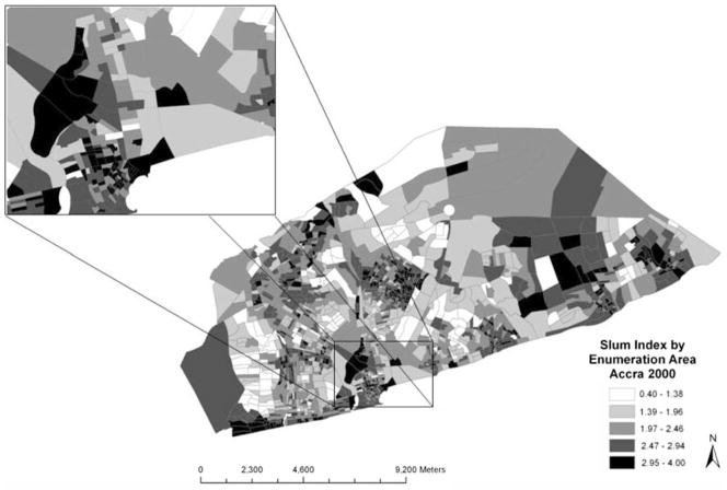
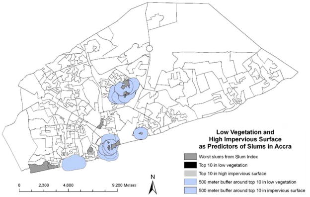
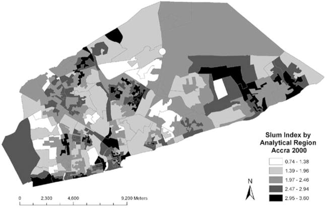
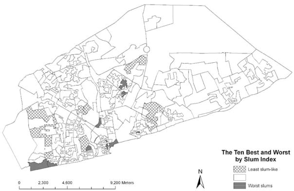
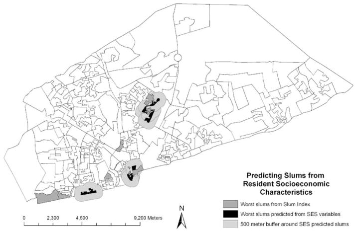
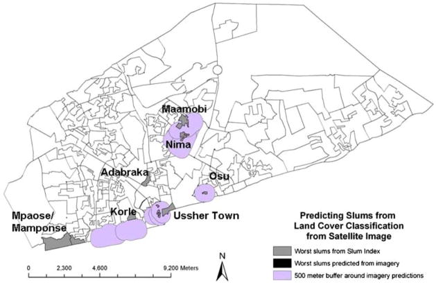
Slums are home to a large fraction of urban residents in cities of developing nations, but little attempt has been made to go beyond a simple slum/non-slum dichotomy, nor to identify slums more quantitatively than through local reputation. We use census data from Accra, Ghana, to create an index that applies the UN-Habitat criteria for a place to be a slum. We use this index to identify neighborhoods on a continuum of slum characteristics and on that basis are able to locate the worst slums in Accra. These do include the areas with a local reputation for being slums, lending qualitative validation to the index. We show that slums also have footprints that can be identified from data classified from satellite imagery. However, variability among slums in Accra is also associated with some variability in the land cover characteristics of slums.

摘要

在发展中国家的城市中,贫民窟是很大一部分城市居民的家园,但除了简单的贫民窟/非贫民窟二分法之外,几乎没有进行过其他尝试,也没有比通过当地声誉更定量地识别贫民窟。我们使用来自加纳阿克拉的人口普查数据,创建了一个应用联合国人居署关于一个地方成为贫民窟标准的指数。我们使用这个指数来识别具有连续贫民窟特征的社区,并在此基础上找出阿克拉最糟糕的贫民窟。这些确实包括那些在当地以贫民窟闻名的地区,从而为该指数提供了定性验证。我们表明,贫民窟也有可以从卫星图像分类数据中识别出来的足迹。然而,阿克拉贫民窟之间的差异也与贫民窟土地覆盖特征的一些差异有关。

https://cdn.ncbi.nlm.nih.gov/pmc/blobs/be2f/2686612/08aa370a499b/nihms97261f6.jpg
https://cdn.ncbi.nlm.nih.gov/pmc/blobs/be2f/2686612/abae93c8b694/nihms97261f1.jpg
https://cdn.ncbi.nlm.nih.gov/pmc/blobs/be2f/2686612/370dd6dcc8b6/nihms97261f2.jpg
https://cdn.ncbi.nlm.nih.gov/pmc/blobs/be2f/2686612/90d2519c5cc2/nihms97261f3.jpg
https://cdn.ncbi.nlm.nih.gov/pmc/blobs/be2f/2686612/81e35f0216d9/nihms97261f4.jpg
https://cdn.ncbi.nlm.nih.gov/pmc/blobs/be2f/2686612/f97d63b136cf/nihms97261f5.jpg
https://cdn.ncbi.nlm.nih.gov/pmc/blobs/be2f/2686612/08aa370a499b/nihms97261f6.jpg

相似文献

1
Can we spot a neighborhood from the air? Defining neighborhood structure in Accra, Ghana.我们能从空中识别出一个社区吗?定义加纳阿克拉的社区结构。
GeoJournal. 2007;69(1-2):9-22. doi: 10.1007/s10708-007-9098-4.
2
Do the Most Vulnerable People Live in the Worst Slums? A Spatial Analysis of Accra, Ghana.最弱势群体是否生活在最糟糕的贫民窟?加纳阿克拉的空间分析
Ann GIS. 2012 Jan 5;17(4):221-235.
3
Assessing the Utility of Satellite Imagery with Differing Spatial Resolutions for Deriving Proxy Measures of Slum Presence in Accra, Ghana.评估不同空间分辨率的卫星图像在推导加纳阿克拉贫民窟存在的代理指标方面的效用。
GIsci Remote Sens. 2012;49(1):31-52. doi: 10.2747/1548-1603.49.1.31.
4
Sexual and reproductive health education and its association with ever use of contraception: a cross-sectional study among women in urban slums, Accra.性与生殖健康教育及其与避孕措施使用情况的关联:加纳城市贫民窟妇女的横断面研究。
Reprod Health. 2022 Jan 15;19(1):7. doi: 10.1186/s12978-021-01322-5.
5
"Our Home Is a Muddy Structure": Perceptions of Housing and Health Risks Among Older Adults in Contrasting Neighborhoods in Ghana.“我们的家是一个泥泞的结构”:加纳对比社区中老年人对住房和健康风险的看法。
Front Public Health. 2021 Apr 22;9:650861. doi: 10.3389/fpubh.2021.650861. eCollection 2021.
6
Identifying deprived "slum" neighbourhoods in the Greater Accra Metropolitan Area of Ghana using census and remote sensing data.利用人口普查和遥感数据识别加纳大阿克拉都会区贫困的“贫民窟”社区。
World Dev. 2023 Jul;167:106253. doi: 10.1016/j.worlddev.2023.106253.
7
The health of the poor: women living in informal settlements.穷人的健康:居住在非正式定居点的妇女。
Ghana Med J. 2012 Jun;46(2):104-12.
8
Connecting the Dots Between Health, Poverty and Place in Accra, Ghana.连接加纳阿克拉健康、贫困与地域之间的关系
Ann Assoc Am Geogr. 2012;102(5):932-941. doi: 10.1080/00045608.2012.671132.
9
Health, Poverty, and Place in Accra, Ghana: Mapping Neighborhoods.健康、贫困与加纳阿克拉的地域分布:绘制社区地图
J Maps. 2012 Nov 15;8(4):369-373. doi: 10.1080/17445647.2012.744365.
10
Prevalence and correlates of smoking among urban adult men in Bangladesh: slum versus non-slum comparison.孟加拉国城市成年男性吸烟的患病率及其相关因素:贫民窟与非贫民窟对比
BMC Public Health. 2009 May 22;9:149. doi: 10.1186/1471-2458-9-149.

引用本文的文献

1
Newborn thermal care practices in two urban slums in southern Ghana: evidence from a concurrent mixed methods study.加纳南部两个城市贫民窟的新生儿体温护理实践:来自一项同期混合方法研究的证据。
BMC Pregnancy Childbirth. 2025 Apr 21;25(1):464. doi: 10.1186/s12884-025-07599-9.
2
Phenotyping urban built and natural environments with high-resolution satellite images and unsupervised deep learning.利用高分辨率卫星图像和无监督深度学习进行城市建成和自然环境的表型分析。
Sci Total Environ. 2023 Oct 1;893:164794. doi: 10.1016/j.scitotenv.2023.164794. Epub 2023 Jun 13.
3
Managing urban solid waste in Ghana: Perspectives and experiences of municipal waste company managers and supervisors in an urban municipality.

本文引用的文献

1
Urban poverty and health in developing countries: household and neighborhood effects.发展中国家的城市贫困与健康:家庭及邻里效应
Demography. 2005 Aug;42(3):397-425. doi: 10.1353/dem.2005.0020.
2
Algorithms for reengineering 1991 census geography.1991年人口普查地理信息重组算法。
Environ Plan A. 1995 Mar;27(3):425-46. doi: 10.1068/a270425.
3
Investigating neighborhood and area effects on health.调查邻里和区域环境对健康的影响。
加纳城市固体废物管理:城市自治市市政废物公司经理和主管的观点和经验。
PLoS One. 2021 Mar 11;16(3):e0248392. doi: 10.1371/journal.pone.0248392. eCollection 2021.
4
Measuring social, environmental and health inequalities using deep learning and street imagery.利用深度学习和街景图像测量社会、环境和健康不平等。
Sci Rep. 2019 Apr 18;9(1):6229. doi: 10.1038/s41598-019-42036-w.
5
A cross-sectional ecological analysis of international and sub-national health inequalities in commercial geospatial resource availability.跨国别和国家级的商业地理空间资源可及性与健康不平等的横断生态学分析。
Int J Health Geogr. 2018 May 23;17(1):14. doi: 10.1186/s12942-018-0134-z.
6
Remote sensing-based measurement of Living Environment Deprivation: Improving classical approaches with machine learning.基于遥感的生活环境剥夺测量:用机器学习改进经典方法。
PLoS One. 2017 May 2;12(5):e0176684. doi: 10.1371/journal.pone.0176684. eCollection 2017.
7
Analytically Derived Neighborhoods in a Rapidly Growing West African City: The Case of Accra, Ghana.快速发展的西非城市中基于分析得出的社区:以加纳阿克拉为例
Habitat Int. 2015 Jan 1;45(2):126-134. doi: 10.1016/j.habitatint.2014.06.021.
8
Migration, sexual networks, and HIV in Agbogbloshie, Ghana.加纳阿博布罗西的人口迁移、性网络与艾滋病病毒
Demogr Res. 2014 Oct 10;31:861-888. doi: 10.4054/DemRes.2014.31.28.
9
Connecting the Dots Between Health, Poverty and Place in Accra, Ghana.连接加纳阿克拉健康、贫困与地域之间的关系
Ann Assoc Am Geogr. 2012;102(5):932-941. doi: 10.1080/00045608.2012.671132.
10
Estimating spatial inequalities of urban child mortality.估算城市儿童死亡率的空间不平等情况。
Demogr Res. 2013 Jan 28;28:33-62. doi: 10.4054/DemRes.2013.28.2.
Am J Public Health. 2001 Nov;91(11):1783-9. doi: 10.2105/ajph.91.11.1783.
4
Bringing context back into epidemiology: variables and fallacies in multilevel analysis.将背景因素重新纳入流行病学:多层次分析中的变量与谬误
Am J Public Health. 1998 Feb;88(2):216-22. doi: 10.2105/ajph.88.2.216.
5
Health and Environment Analysis for Decision-Making (HEADLAMP): field study in Accra, Ghana.用于决策的健康与环境分析(HEADLAMP):加纳阿克拉的实地研究
World Health Stat Q. 1995;48(2):108-17.