University of Calgary, Department of Community Health Sciences, Faculty of Medicine, 3330 Hospital Drive NW Calgary, Alberta, T2N 4N1, Canada.
Int J Behav Nutr Phys Act. 2009 Nov 20;6:77. doi: 10.1186/1479-5868-6-77.
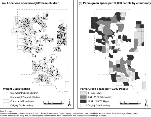
The recent increase in childhood obesity is expected to add significantly to the prevalence of chronic diseases. We used multivariate multilevel analysis to examine associations between parks/green space and childhood overweight/obesity across communities in Calgary, Canada, a city characterized by intensified urban sprawl and high car use.
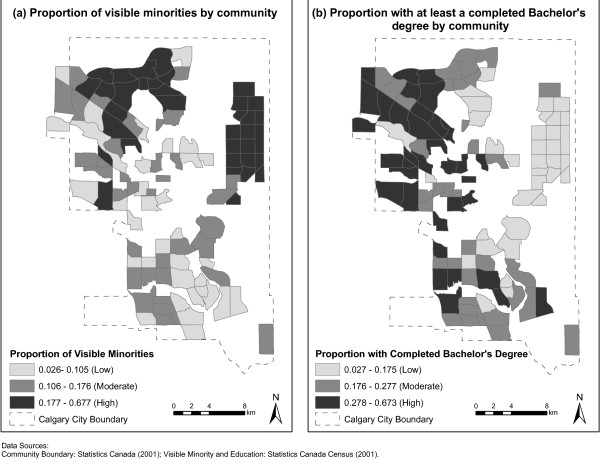
Body Mass Index was calculated from measured height and weight data obtained from 6,772 children (mean age = 4.95 years) attending public health clinics for pre-school vaccinations. Each child's home postal code was geocoded using ESRI ArcGIS 9.2. We examined four measures of spatial access to parks/green space (based on Geographic Information Systems): 1) the number of parks/green spaces per 10,000 residents, 2) the area of parks/green space as a proportion of the total area within a community, 3) average distance to a park/green space, and 4) the proportion of parks/green space service area as a proportion of the total area within a community. Analyses were adjusted for dissemination area median family income (as a proxy for an individual child's family income) community-level education, and community-level proportion of visible minorities.
In general, parks/green space at the community level was not associated with overweight/obesity in Calgary, with the exception of a marginally significant effect whereby a moderate number of parks/green spaces per 10,000 residents was associated with lower odds of overweight/obesity. This effect was non-significant in adjusted analyses.
Our null findings may reflect the popularity of car travel in Calgary, Canada and suggest that the role built environment characteristics play in explaining health outcomes may differ depending on the type of urban environment being studied.
儿童肥胖率的最近上升预计会显著增加慢性病的发病率。我们采用多变量多层分析方法,检验了在加拿大卡尔加里市社区层面上公园/绿地与儿童超重/肥胖之间的关系,卡尔加里市的特点是城市无序扩张加剧和汽车使用率高。
从参加学前疫苗接种公共卫生诊所的 6772 名儿童(平均年龄=4.95 岁)的测量身高和体重数据中计算出体重指数。使用 ESRI ArcGIS 9.2 将每个儿童的家庭邮政编码进行地理编码。我们检查了四种空间可达性测量方法来评估公园/绿地(基于地理信息系统):1)每 10000 名居民的公园/绿地数量,2)公园/绿地面积占社区总面积的比例,3)到公园/绿地的平均距离,以及 4)公园/绿地服务区面积占社区总面积的比例。分析结果调整了传播区域中值家庭收入(作为个体儿童家庭收入的代理)、社区教育水平和社区可见少数群体的比例。
一般来说,社区层面的公园/绿地与卡尔加里的超重/肥胖无关,除了一个中等数量的公园/绿地每 10000 名居民与较低的超重/肥胖几率相关,这一关联在调整分析中不显著。
我们的无效结果可能反映了在加拿大卡尔加里市汽车出行的普及,并且表明,在研究不同类型的城市环境时,建成环境特征在解释健康结果方面的作用可能不同。