Department of Epidemiology, University of Michigan, Ann Arbor, MI, USA.
Malar J. 2010 Nov 16;9:328. doi: 10.1186/1475-2875-9-328.
Identification of high-risk malaria foci can help enhance surveillance or control activities in regions where they are most needed. Associations between malaria risk and land-use/land-cover are well-recognized, but these environmental characteristics are closely interrelated with the land's topography (e.g., hills, valleys, elevation), which also influences malaria risk strongly. Parsing the individual contributions of land-cover/land-use variables to malaria risk requires examining these associations in the context of their topographic landscape. This study examined whether environmental factors like land-cover, land-use, and urban density improved malaria risk prediction based solely on the topographically-determined context, as measured by the topographic wetness index.
The topographic wetness index, an estimate of predicted water accumulation in a defined area, was generated from a digital terrain model of the landscape surrounding households in two neighbouring western Kenyan highland communities. Variables determined to best encompass the variance in this topographic wetness surface were calculated at a household level. Land-cover/land-use information was extracted from a high-resolution satellite image using an object-based classification method. Topographic and land-cover variables were used individually and in combination to predict household-level malaria in the communities through an iterative split-sample model fitting and testing procedure. Models with only topographic variables were compared to those with additional predictive factors related to land-cover/land-use to investigate whether these environmental factors improved prediction of malaria based on the shape of the land alone.
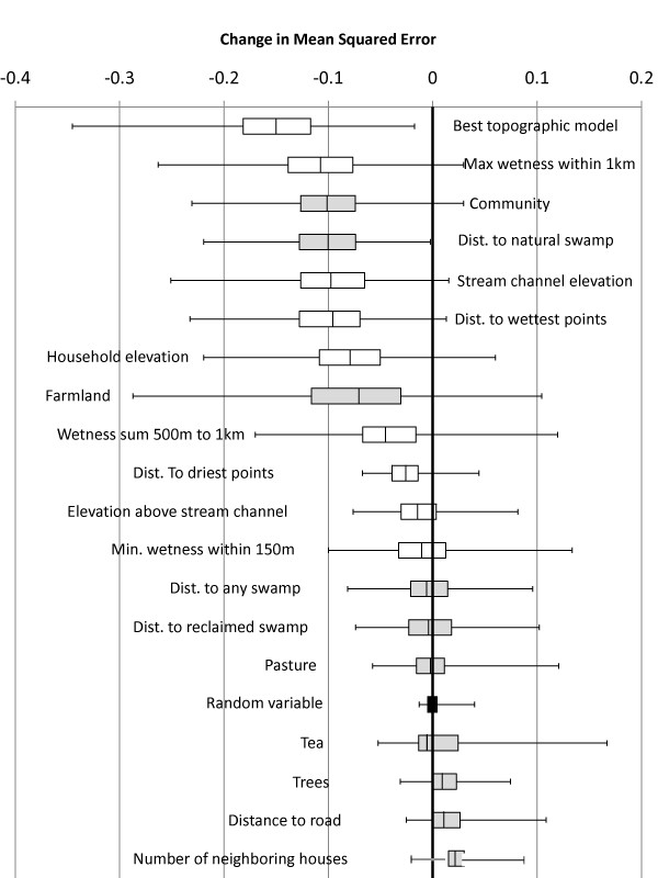
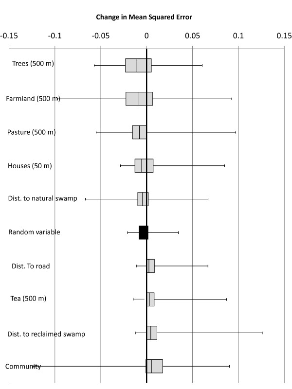
Variables related to topographic wetness proved most useful in predicting the households of individuals contracting malaria in this region of rugged terrain. Other variables related to human modification of the environment also demonstrated clear associations with household malaria. However, these land-cover/land-use variables failed to produce unambiguous improvements in statistical predictive models controlling for important topographic factors, with none improving prediction of household-level malaria more than 75% of the time.
Topographic wetness values in this region of highly varied terrain more accurately predicted houses at greater risk of malaria than did consideration of land-cover/land-use characteristics. As such, those planning control or local elimination strategies in similar highland regions may use topographic and geographic characteristics to effectively identify high-receptivity regions that may require enhanced vigilance.
识别高风险疟疾热点有助于加强最需要的地区的监测或控制活动。疟疾风险与土地利用/土地覆盖之间的关联已得到充分认识,但这些环境特征与地形密切相关(如丘陵、山谷、海拔),地形也强烈影响疟疾风险。解析土地覆盖/土地利用变量对疟疾风险的单独贡献需要在其地形景观的背景下检查这些关联。本研究检验了土地覆盖、土地利用和城市密度等环境因素是否能够提高仅基于地形确定的上下文(由地形湿度指数衡量)的疟疾风险预测。
地形湿度指数是对定义区域内预测积水的估计,它是从周围家庭的地形模型生成的。在家庭层面上计算出最能涵盖该地形湿度表面变化的变量。从高分辨率卫星图像中提取土地覆盖/土地利用信息,使用基于对象的分类方法。地形和土地覆盖变量分别和组合用于通过迭代的样本分割模型拟合和测试程序预测社区内家庭层面的疟疾。仅使用地形变量的模型与具有与土地覆盖/土地利用相关的额外预测因子的模型进行比较,以调查这些环境因素是否仅基于地形形状就能改善疟疾的预测。
与地形湿度相关的变量在预测该地区崎岖地形中感染疟疾的个体家庭方面最有用。与人类对环境的改造有关的其他变量也与家庭疟疾有明显的关联。然而,这些土地覆盖/土地利用变量未能在控制重要地形因素的统计预测模型中产生明确的改进,没有一个能在 75%以上的时间提高家庭层面疟疾的预测。
在这个高度多变地形的地区,地形湿度值比考虑土地覆盖/土地利用特征更能准确预测疟疾风险较高的房屋。因此,在类似的高地地区规划控制或局部消除策略的人员可能会使用地形和地理特征来有效地识别可能需要加强警惕的高接受性区域。