• 文献检索
  • 文档翻译
  • 深度研究
  • 学术资讯
  • Suppr Zotero 插件Zotero 插件
  • 邀请有礼
  • 套餐&价格
  • 历史记录
应用&插件
Suppr Zotero 插件Zotero 插件浏览器插件Mac 客户端Windows 客户端微信小程序
定价
高级版会员购买积分包购买API积分包
服务
文献检索文档翻译深度研究API 文档MCP 服务
关于我们
关于 Suppr公司介绍联系我们用户协议隐私条款
关注我们

Suppr 超能文献

核心技术专利:CN118964589B侵权必究
粤ICP备2023148730 号-1Suppr @ 2026

文献检索

告别复杂PubMed语法,用中文像聊天一样搜索,搜遍4000万医学文献。AI智能推荐,让科研检索更轻松。

立即免费搜索

文件翻译

保留排版,准确专业,支持PDF/Word/PPT等文件格式,支持 12+语言互译。

免费翻译文档

深度研究

AI帮你快速写综述,25分钟生成高质量综述,智能提取关键信息,辅助科研写作。

立即免费体验

免费且简单的 GIS 适用于资源匮乏环境下的健康地图绘制:印度尼西亚东部的一个案例研究。

Free and simple GIS as appropriate for health mapping in a low resource setting: a case study in eastern Indonesia.

机构信息

Charles Darwin University, Darwin, Northern Territory 0909, Australia.

出版信息

Int J Health Geogr. 2011 Feb 25;10:15. doi: 10.1186/1476-072X-10-15.

DOI:10.1186/1476-072X-10-15
PMID:21352553
原文链接:https://pmc.ncbi.nlm.nih.gov/articles/PMC3051879/
Abstract

BACKGROUND

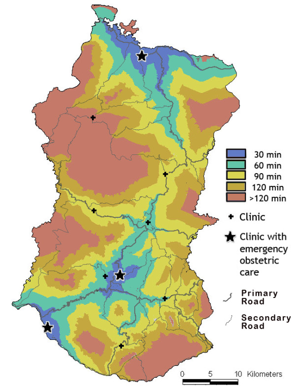
Despite the demonstrated utility of GIS for health applications, there are perceived problems in low resource settings: GIS software can be expensive and complex; input data are often of low quality. This study aimed to test the appropriateness of new, inexpensive and simple GIS tools in poorly resourced areas of a developing country. GIS applications were trialled in pilot studies based on mapping of health resources and health indicators at the clinic and district level in the predominantly rural province of Nusa Tenggara Timur in eastern Indonesia. The pilot applications were (i) rapid field collection of health infrastructure data using a GPS enabled PDA, (ii) mapping health indicator data using open source GIS software, and (iii) service availability mapping using a free modelling tool.

RESULTS

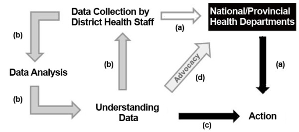
Through contextualised training, district and clinic staff acquired skills in spatial analysis and visualisation and, six months after the pilot studies, they were using these skills for advocacy in the planning process, to inform the allocation of some health resources, and to evaluate some public health initiatives.

CONCLUSIONS

We demonstrated that GIS can be a useful and inexpensive tool for the decentralisation of health data analysis to low resource settings through the use of free and simple software, locally relevant training materials and by providing data collection tools to ensure data reliability.

摘要

背景

尽管 GIS 在卫生应用中已经得到了证明,但在资源匮乏的环境中仍存在一些问题:GIS 软件可能昂贵且复杂;输入数据的质量通常较低。本研究旨在测试在发展中国家资源匮乏地区使用新的、廉价且简单的 GIS 工具的适宜性。在印度尼西亚东部以农村为主的东努沙登加拉省,我们在试点研究中试用了 GIS 应用程序,这些研究基于诊所和地区层面的卫生资源和卫生指标的制图。试点应用包括:(i) 使用支持 GPS 的 PDA 快速现场收集卫生基础设施数据,(ii) 使用开源 GIS 软件绘制卫生指标数据,以及 (iii) 使用免费建模工具进行服务可用性制图。

结果

通过有针对性的培训,地区和诊所工作人员获得了空间分析和可视化技能,并且在试点研究结束后的六个月后,他们将这些技能用于规划过程中的宣传,以告知部分卫生资源的分配,并评估一些公共卫生计划。

结论

我们通过使用免费且简单的软件、本地相关的培训材料以及提供数据收集工具来确保数据的可靠性,展示了 GIS 可以成为将卫生数据分析去中心化到资源匮乏环境中的有用且廉价的工具。

https://cdn.ncbi.nlm.nih.gov/pmc/blobs/106f/3051879/affbb5fb61b6/1476-072X-10-15-6.jpg
https://cdn.ncbi.nlm.nih.gov/pmc/blobs/106f/3051879/51cbd73cd6ab/1476-072X-10-15-1.jpg
https://cdn.ncbi.nlm.nih.gov/pmc/blobs/106f/3051879/39ef64d12821/1476-072X-10-15-2.jpg
https://cdn.ncbi.nlm.nih.gov/pmc/blobs/106f/3051879/bf26427b2c61/1476-072X-10-15-3.jpg
https://cdn.ncbi.nlm.nih.gov/pmc/blobs/106f/3051879/f4eda7d1ed9a/1476-072X-10-15-4.jpg
https://cdn.ncbi.nlm.nih.gov/pmc/blobs/106f/3051879/2c674e32482f/1476-072X-10-15-5.jpg
https://cdn.ncbi.nlm.nih.gov/pmc/blobs/106f/3051879/affbb5fb61b6/1476-072X-10-15-6.jpg

相似文献

1
Free and simple GIS as appropriate for health mapping in a low resource setting: a case study in eastern Indonesia.免费且简单的 GIS 适用于资源匮乏环境下的健康地图绘制:印度尼西亚东部的一个案例研究。
Int J Health Geogr. 2011 Feb 25;10:15. doi: 10.1186/1476-072X-10-15.
2
Leveraging community health worker system to map a mountainous rural district in low resource setting: a low-cost approach to expand use of geographic information systems for public health.利用社区卫生工作者系统在资源匮乏地区绘制山区农村地图:一种低成本的方法,以扩大地理信息系统在公共卫生中的应用。
Int J Health Geogr. 2014 Dec 6;13:49. doi: 10.1186/1476-072X-13-49.
3
Scenario modelling as planning evidence to improve access to emergency obstetric care in eastern Indonesia.情景模拟作为规划证据,以改善印度尼西亚东部获得紧急产科护理的机会。
PLoS One. 2021 Jun 9;16(6):e0251869. doi: 10.1371/journal.pone.0251869. eCollection 2021.
4
Open source GIS for HIV/AIDS management.用于艾滋病毒/艾滋病管理的开源地理信息系统
Int J Health Geogr. 2008 Oct 22;7:53. doi: 10.1186/1476-072X-7-53.
5
Spatial and multidimensional visualization of Indonesia's village health statistics.印度尼西亚乡村健康统计数据的空间与多维可视化
Int J Health Geogr. 2008 Jun 11;7:30. doi: 10.1186/1476-072X-7-30.
6
Using participatory design to develop (public) health decision support systems through GIS.利用参与式设计通过地理信息系统开发(公共)卫生决策支持系统。
Int J Health Geogr. 2007 Nov 27;6:53. doi: 10.1186/1476-072X-6-53.
7
Interactive, open source, travel time scenario modelling: tools to facilitate participation in health service access analysis.交互式、开源的旅行时间情景建模:促进参与医疗服务可及性分析的工具。
Int J Health Geogr. 2017 Apr 18;16(1):13. doi: 10.1186/s12942-017-0086-8.
8
Harnessing Geographic Information Systems (GIS) to enable community-oriented primary care.利用地理信息系统(GIS)实现面向社区的初级保健。
J Am Board Fam Med. 2010 Jan-Feb;23(1):22-31. doi: 10.3122/jabfm.2010.01.090097.
9
Using GIS and secondary data to target diabetes-related public health efforts.利用 GIS 和二手数据来针对糖尿病相关的公共卫生工作。
Public Health Rep. 2013 May-Jun;128(3):212-20. doi: 10.1177/003335491312800311.
10
The use of open source GIS algorithms, big geographic data, and cluster computing techniques to compile a geospatial database that can be used to evaluate upstream bathing and sanitation behaviours on downstream health outcomes in Indonesia, 2000-2008.利用开源 GIS 算法、大型地理数据和集群计算技术,编制了一个地理空间数据库,用于评估 2000-2008 年印度尼西亚上游沐浴和卫生行为对下游健康结果的影响。
Int J Health Geogr. 2018 Dec 14;17(1):44. doi: 10.1186/s12942-018-0164-6.

引用本文的文献

1
Human factors methods in the design of digital decision support systems for population health: a scoping review.人群健康数字化决策支持系统设计中的人为因素方法:范围综述。
BMC Public Health. 2024 Sep 10;24(1):2458. doi: 10.1186/s12889-024-19968-8.
2
Open source framework for a Broadly Expandable and Reconfigurable data acquisition and automation device (BREAD).用于广泛可扩展和可重新配置的数据采集与自动化设备(BREAD)的开源框架。
HardwareX. 2023 Aug 25;15:e00467. doi: 10.1016/j.ohx.2023.e00467. eCollection 2023 Sep.
3
Spatial evaluation of healthcare accessibility across archipelagic communities of Maluku Province, Indonesia.

本文引用的文献

1
Enabling methods for community health mapping in developing countries.发展中国家社区卫生绘图的实现方法。
Int J Health Geogr. 2010 Oct 29;9:56. doi: 10.1186/1476-072X-9-56.
2
Tracking the Global Express: new tools addressing disease threats across the world.追踪全球快报:应对全球疾病威胁的新工具。
Epidemiology. 2010 Nov;21(6):769-71. doi: 10.1097/EDE.0b013e3181f56757.
3
A high resolution spatial population database of Somalia for disease risk mapping.高分辨率的索马里空间人口数据库,用于疾病风险制图。
印度尼西亚马鲁古省群岛社区医疗服务可及性的空间评估。
PLOS Glob Public Health. 2023 Mar 9;3(3):e0001600. doi: 10.1371/journal.pgph.0001600. eCollection 2023.
4
The development and validation of a dashboard prototype for real-time suicide mortality data.实时自杀死亡率数据仪表盘原型的开发与验证
Front Digit Health. 2022 Aug 20;4:909294. doi: 10.3389/fdgth.2022.909294. eCollection 2022.
5
National optimisation of accessibility to emergency obstetrical and neonatal care in Togo: a geospatial analysis.多哥国家优化紧急产科和新生儿护理的可及性:一项地理空间分析。
BMJ Open. 2021 Jul 30;11(7):e045891. doi: 10.1136/bmjopen-2020-045891.
6
Scenario modelling as planning evidence to improve access to emergency obstetric care in eastern Indonesia.情景模拟作为规划证据,以改善印度尼西亚东部获得紧急产科护理的机会。
PLoS One. 2021 Jun 9;16(6):e0251869. doi: 10.1371/journal.pone.0251869. eCollection 2021.
7
Addressing the data guardian and geospatial scientist collaborator dilemma: how to share health records for spatial analysis while maintaining patient confidentiality.解决数据保护者和地理空间科学家协作困境:如何在保护患者隐私的同时共享健康记录进行空间分析。
Int J Health Geogr. 2019 Dec 21;18(1):30. doi: 10.1186/s12942-019-0194-8.
8
Establishing a Demographic, Development and Environmental Geospatial Surveillance Platform in India: Planning and Implementation.在印度建立人口、发展与环境地理空间监测平台:规划与实施
JMIR Public Health Surveill. 2018 Oct 5;4(4):e66. doi: 10.2196/publichealth.9749.
9
Interactive, open source, travel time scenario modelling: tools to facilitate participation in health service access analysis.交互式、开源的旅行时间情景建模:促进参与医疗服务可及性分析的工具。
Int J Health Geogr. 2017 Apr 18;16(1):13. doi: 10.1186/s12942-017-0086-8.
10
An Online Atlas for Exploring Spatio-Temporal Patterns of Cancer Mortality (1972-2011) and Incidence (1995-2008) in Taiwan.台湾癌症死亡率(1972 - 2011年)和发病率(1995 - 2008年)时空模式探索在线图谱。
Medicine (Baltimore). 2016 May;95(21):e3496. doi: 10.1097/MD.0000000000003496.
Int J Health Geogr. 2010 Sep 14;9:45. doi: 10.1186/1476-072X-9-45.
4
Injury surveillance in low-resource settings using Geospatial and Social Web technologies.利用地理空间和社会网络技术进行低资源环境下的伤害监测。
Int J Health Geogr. 2010 May 24;9:25. doi: 10.1186/1476-072X-9-25.
5
Combining Google Earth and GIS mapping technologies in a dengue surveillance system for developing countries.在发展中国家的登革热监测系统中结合谷歌地球和地理信息系统绘图技术。
Int J Health Geogr. 2009 Jul 23;8:49. doi: 10.1186/1476-072X-8-49.
6
AccessMod 3.0: computing geographic coverage and accessibility to health care services using anisotropic movement of patients.AccessMod 3.0:利用患者的各向异性移动计算医疗保健服务的地理覆盖范围和可及性。
Int J Health Geogr. 2008 Dec 16;7:63. doi: 10.1186/1476-072X-7-63.
7
Open source GIS for HIV/AIDS management.用于艾滋病毒/艾滋病管理的开源地理信息系统
Int J Health Geogr. 2008 Oct 22;7:53. doi: 10.1186/1476-072X-7-53.
8
Use of Google Earth to strengthen public health capacity and facilitate management of vector-borne diseases in resource-poor environments.利用谷歌地球增强资源匮乏环境下的公共卫生能力并促进病媒传播疾病的管理。
Bull World Health Organ. 2008 Sep;86(9):718-25. doi: 10.2471/blt.07.045880.
9
Spatial and multidimensional visualization of Indonesia's village health statistics.印度尼西亚乡村健康统计数据的空间与多维可视化
Int J Health Geogr. 2008 Jun 11;7:30. doi: 10.1186/1476-072X-7-30.
10
Clinical peripherality: development of a peripherality index for rural health services.临床边缘性:农村卫生服务边缘性指数的制定
BMC Health Serv Res. 2008 Jan 25;8:23. doi: 10.1186/1472-6963-8-23.