• 文献检索
  • 文档翻译
  • 深度研究
  • 学术资讯
  • Suppr Zotero 插件Zotero 插件
  • 邀请有礼
  • 套餐&价格
  • 历史记录
应用&插件
Suppr Zotero 插件Zotero 插件浏览器插件Mac 客户端Windows 客户端微信小程序
定价
高级版会员购买积分包购买API积分包
服务
文献检索文档翻译深度研究API 文档MCP 服务
关于我们
关于 Suppr公司介绍联系我们用户协议隐私条款
关注我们

Suppr 超能文献

核心技术专利:CN118964589B侵权必究
粤ICP备2023148730 号-1Suppr @ 2026

文献检索

告别复杂PubMed语法,用中文像聊天一样搜索,搜遍4000万医学文献。AI智能推荐,让科研检索更轻松。

立即免费搜索

文件翻译

保留排版,准确专业,支持PDF/Word/PPT等文件格式,支持 12+语言互译。

免费翻译文档

深度研究

AI帮你快速写综述,25分钟生成高质量综述,智能提取关键信息,辅助科研写作。

立即免费体验

AccessMod 3.0:利用患者的各向异性移动计算医疗保健服务的地理覆盖范围和可及性。

AccessMod 3.0: computing geographic coverage and accessibility to health care services using anisotropic movement of patients.

作者信息

Ray Nicolas, Ebener Steeve

机构信息

Information, Evidence and Research, World Health Organization, 20 av, Appia, 1211 Geneva 27, Switzerland.

出版信息

Int J Health Geogr. 2008 Dec 16;7:63. doi: 10.1186/1476-072X-7-63.

DOI:10.1186/1476-072X-7-63
PMID:19087277
原文链接:https://pmc.ncbi.nlm.nih.gov/articles/PMC2651127/
Abstract

BACKGROUND

Access to health care can be described along four dimensions: geographic accessibility, availability, financial accessibility and acceptability. Geographic accessibility measures how physically accessible resources are for the population, while availability reflects what resources are available and in what amount. Combining these two types of measure into a single index provides a measure of geographic (or spatial) coverage, which is an important measure for assessing the degree of accessibility of a health care network.

RESULTS

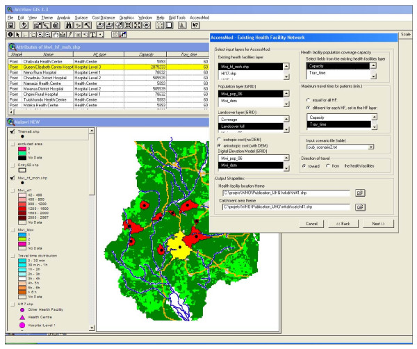
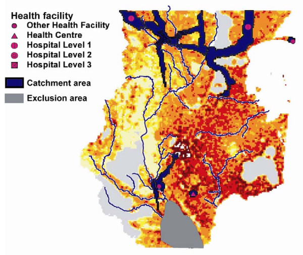
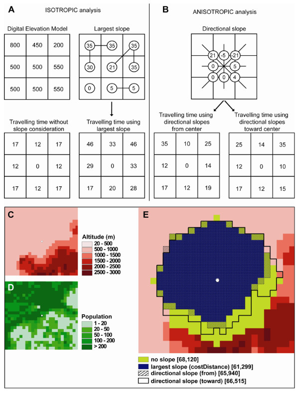
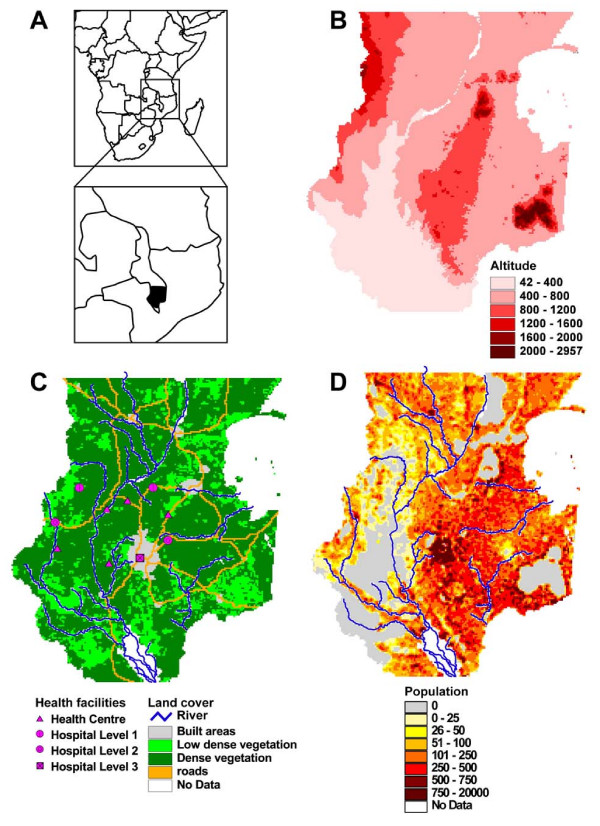
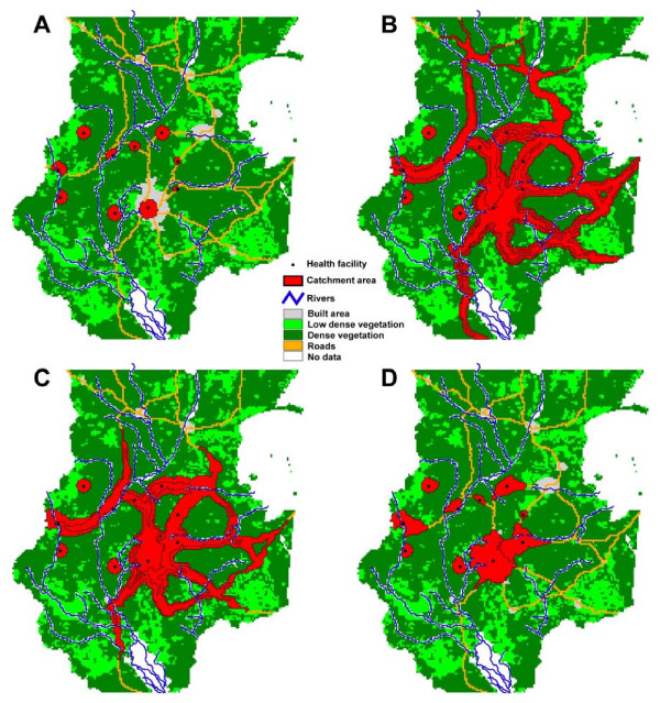
This paper describes the latest version of AccessMod, an extension to the Geographical Information System ArcView 3.x, and provides an example of application of this tool. AccessMod 3 allows one to compute geographic coverage to health care using terrain information and population distribution. Four major types of analysis are available in AccessMod: (1) modeling the coverage of catchment areas linked to an existing health facility network based on travel time, to provide a measure of physical accessibility to health care; (2) modeling geographic coverage according to the availability of services; (3) projecting the coverage of a scaling-up of an existing network; (4) providing information for cost effectiveness analysis when little information about the existing network is available. In addition to integrating travelling time, population distribution and the population coverage capacity specific to each health facility in the network, AccessMod can incorporate the influence of landscape components (e.g. topography, river and road networks, vegetation) that impact travelling time to and from facilities. Topographical constraints can be taken into account through an anisotropic analysis that considers the direction of movement. We provide an example of the application of AccessMod in the southern part of Malawi that shows the influences of the landscape constraints and of the modes of transportation on geographic coverage.

CONCLUSION

By incorporating the demand (population) and the supply (capacities of heath care centers), AccessMod provides a unifying tool to efficiently assess the geographic coverage of a network of health care facilities. This tool should be of particular interest to developing countries that have a relatively good geographic information on population distribution, terrain, and health facility locations.

摘要

背景

医疗保健可从四个维度来描述:地理可及性、可获得性、经济可及性和可接受性。地理可及性衡量的是人口获取资源的实际便利程度,而可获得性反映的是现有资源及其数量。将这两种衡量方式整合为一个单一指标可得出地理(或空间)覆盖范围,这是评估医疗保健网络可及程度的一项重要指标。

结果

本文介绍了AccessMod的最新版本,它是地理信息系统ArcView 3.x的一个扩展,并给出了该工具的应用示例。AccessMod 3使人们能够利用地形信息和人口分布来计算医疗保健的地理覆盖范围。AccessMod有四种主要类型的分析:(1)基于出行时间对与现有医疗机构网络相连的服务区域覆盖范围进行建模,以衡量获得医疗保健的实际便利程度;(2)根据服务的可获得性对地理覆盖范围进行建模;(3)预测现有网络扩大规模后的覆盖范围;(4)在关于现有网络的信息很少时,为成本效益分析提供信息。除了整合出行时间、人口分布以及网络中每个医疗机构特定的人口覆盖能力外,AccessMod还能纳入影响往返医疗机构出行时间的景观要素(如地形、河流和道路网络、植被)的影响。可以通过考虑移动方向的各向异性分析来考虑地形限制。我们给出了AccessMod在马拉维南部应用的一个示例,该示例展示了景观限制和交通方式对地理覆盖范围的影响。

结论

通过纳入需求(人口)和供给(医疗保健中心的能力),AccessMod提供了一个统一的工具来有效评估医疗机构网络的地理覆盖范围。对于在人口分布、地形和医疗机构位置方面拥有相对良好地理信息的发展中国家而言,这个工具应会特别有用。

https://cdn.ncbi.nlm.nih.gov/pmc/blobs/3562/2651127/6172201875be/1476-072X-7-63-7.jpg
https://cdn.ncbi.nlm.nih.gov/pmc/blobs/3562/2651127/b4fe13ad1366/1476-072X-7-63-1.jpg
https://cdn.ncbi.nlm.nih.gov/pmc/blobs/3562/2651127/86293de24a22/1476-072X-7-63-2.jpg
https://cdn.ncbi.nlm.nih.gov/pmc/blobs/3562/2651127/4dc9be3a160f/1476-072X-7-63-3.jpg
https://cdn.ncbi.nlm.nih.gov/pmc/blobs/3562/2651127/8e0a86e8334c/1476-072X-7-63-4.jpg
https://cdn.ncbi.nlm.nih.gov/pmc/blobs/3562/2651127/5f77b3ca07a8/1476-072X-7-63-5.jpg
https://cdn.ncbi.nlm.nih.gov/pmc/blobs/3562/2651127/7216327b5321/1476-072X-7-63-6.jpg
https://cdn.ncbi.nlm.nih.gov/pmc/blobs/3562/2651127/6172201875be/1476-072X-7-63-7.jpg

相似文献

1
AccessMod 3.0: computing geographic coverage and accessibility to health care services using anisotropic movement of patients.AccessMod 3.0:利用患者的各向异性移动计算医疗保健服务的地理覆盖范围和可及性。
Int J Health Geogr. 2008 Dec 16;7:63. doi: 10.1186/1476-072X-7-63.
2
Geographical accessibility and spatial coverage modelling of public health care network in rural and remote India.印度农村和偏远地区公共医疗保健网络的地理可达性和空间覆盖建模。
PLoS One. 2020 Oct 21;15(10):e0239326. doi: 10.1371/journal.pone.0239326. eCollection 2020.
3
Geographical accessibility and spatial coverage modeling of the primary health care network in the Western Province of Rwanda.卢旺达西部初级卫生保健网络的地理可达性和空间覆盖建模。
Int J Health Geogr. 2012 Sep 17;11:40. doi: 10.1186/1476-072X-11-40.
4
Modelling geographical accessibility to support disaster response and rehabilitation of a healthcare system: an impact analysis of Cyclones Idai and Kenneth in Mozambique.建立地理可达性模型以支持灾害应对和医疗系统恢复:莫桑比克伊代和肯尼斯气旋的影响分析。
BMJ Open. 2020 Nov 3;10(11):e039138. doi: 10.1136/bmjopen-2020-039138.
5
[Estimation of a geographic accessibility index of different health centers in Mexico].[墨西哥不同医疗中心地理可达性指数的估计]
Rev Med Chil. 2008 Dec;136(12):1574-81. Epub 2009 Mar 23.
6
Travel time to health-care facilities, mode of transportation, and HIV elimination in Malawi: a geospatial modelling analysis.前往医疗机构的时间、交通方式与马拉维的艾滋病消除:一项地理空间建模分析。
Lancet Glob Health. 2020 Dec;8(12):e1555-e1564. doi: 10.1016/S2214-109X(20)30351-X.
7
Measuring spatial equity and access to maternal health services using enhanced two step floating catchment area method (E2SFCA) - a case study of the Indian Sundarbans.使用增强型两步浮动集水区法(E2SFCA)衡量孕产妇保健服务的空间公平性和可及性——以印度孙德尔本斯为例
Int J Equity Health. 2016 Jun 7;15:87. doi: 10.1186/s12939-016-0376-y.
8
Geographic accessibility to public health facilities providing tuberculosis testing services at point-of-care in the upper east region, Ghana.加纳上东部地区提供即时护理结核病检测服务的公共卫生设施的地理可达性。
BMC Public Health. 2019 Jun 10;19(1):718. doi: 10.1186/s12889-019-7052-2.
9
Investigation of disparities in geographic accessibility to emergency stroke and myocardial infarction care in East tennessee using geographic information systems and network analysis.使用地理信息系统和网络分析调查东田纳西州紧急脑卒中与心肌梗死治疗的地理可达性方面的差异。
Ann Epidemiol. 2010 Dec;20(12):924-30. doi: 10.1016/j.annepidem.2010.06.013.
10
Geographical access to point-of-care testing for hypertensive disorders of pregnancy as an integral part of maternal healthcare in Ghana.加纳将高血压妊娠点检测作为孕产妇保健的一个组成部分,提供地理上可及的服务。
BMC Pregnancy Childbirth. 2020 Nov 25;20(1):733. doi: 10.1186/s12884-020-03441-6.

引用本文的文献

1
Strengthening Outbreak Detection in Africa to Achieve the 7-1-7 Global Framework: Challenges and Opportunities.加强非洲的疫情检测以实现7-1-7全球框架:挑战与机遇
Public Health Rev. 2025 Aug 14;46:1608039. doi: 10.3389/phrs.2025.1608039. eCollection 2025.
2
Spatial optimization of hierarchical healthcare facilities driven by multi-source data: a case study of Shenyang, China.多源数据驱动的分级医疗设施空间优化:以中国沈阳为例
Front Public Health. 2025 Jul 25;13:1640070. doi: 10.3389/fpubh.2025.1640070. eCollection 2025.
3
Mapping and quantifying travel time to define health facility catchment areas in Blantyre city in Malawi.

本文引用的文献

1
Gender bias in access to healthcare in Nigeria: a study of end-stage renal disease.尼日利亚医疗保健获取中的性别偏见:终末期肾病研究
Trop Doct. 2008 Jan;38(1):50-2. doi: 10.1258/td.2007.060160.
2
Comparing alternative approaches to measuring the geographical accessibility of urban health services: Distance types and aggregation-error issues.比较衡量城市卫生服务地理可及性的替代方法:距离类型和汇总误差问题。
Int J Health Geogr. 2008 Feb 18;7:7. doi: 10.1186/1476-072X-7-7.
3
Poverty and access to health care in developing countries.发展中国家的贫困与医疗保健服务可及性
绘制并量化出行时间以界定马拉维布兰太尔市的医疗机构服务范围
Commun Med (Lond). 2025 Jun 11;5(1):227. doi: 10.1038/s43856-025-00845-3.
4
Paediatric anaemia in rural Kenya and the role of travel time to emergency care services.肯尼亚农村地区的儿童贫血症以及前往急救服务机构的出行时间的影响
Front Epidemiol. 2025 May 15;5:1578522. doi: 10.3389/fepid.2025.1578522. eCollection 2025.
5
Medical accessibility and underreporting of occupational diseases: effect of travel distance and travel time.职业病的医疗可及性与漏报情况:出行距离和出行时间的影响
Front Rehabil Sci. 2025 Apr 7;6:1545460. doi: 10.3389/fresc.2025.1545460. eCollection 2025.
6
Beyond proximity: an observational study of stillbirth rates and emergency obstetric and newborn care accessibility in The Gambia.超越距离:冈比亚死产率与紧急产科和新生儿护理可及性的观察性研究
BMJ Glob Health. 2025 Apr 3;10(4):e016579. doi: 10.1136/bmjgh-2024-016579.
7
A scoping review of the methods used to estimate health facility catchment populations for child health indicators in sub-Saharan Africa.对撒哈拉以南非洲地区用于估算儿童健康指标的卫生设施服务人口的方法进行的一项范围综述。
Popul Health Metr. 2025 Mar 29;23(1):11. doi: 10.1186/s12963-025-00374-0.
8
Modelling the spatial variability and uncertainty for under-vaccination and zero-dose children in fragile settings.在脆弱环境中建模未接种疫苗和零剂量儿童的空间变异性和不确定性。
Sci Rep. 2024 Oct 17;14(1):24405. doi: 10.1038/s41598-024-74982-5.
9
Zero-Dose Childhood Vaccination Status in Rural Democratic Republic of Congo: Quantifying the Relative Impact of Geographic Accessibility and Attitudes toward Vaccination.刚果民主共和国农村地区儿童零剂量疫苗接种状况:量化地理可及性和疫苗接种态度的相对影响
Vaccines (Basel). 2024 Jun 4;12(6):617. doi: 10.3390/vaccines12060617.
10
Optimization of the emergency obstetric and neonatal care network in Benin through expert-based sub-national prioritizations.通过基于专家的国家以下层面优先排序优化贝宁的紧急产科和新生儿护理网络。
Front Glob Womens Health. 2024 Jun 3;5:1265729. doi: 10.3389/fgwh.2024.1265729. eCollection 2024.
Ann N Y Acad Sci. 2008;1136:161-71. doi: 10.1196/annals.1425.011. Epub 2007 Oct 22.
4
Modelling the spatial distribution of five natural hazards in the context of the WHO/EMRO Atlas of Disaster Risk as a step towards the reduction of the health impact related to disasters.在世卫组织/东地中海区域办事处灾害风险地图集的背景下,对五种自然灾害的空间分布进行建模,作为减少与灾害相关的健康影响的第一步。
Int J Health Geogr. 2007 Mar 7;6:8. doi: 10.1186/1476-072X-6-8.
5
Validation of travel times to hospital estimated by GIS.通过地理信息系统(GIS)估算前往医院的行程时间的验证。
Int J Health Geogr. 2006 Sep 19;5:40. doi: 10.1186/1476-072X-5-40.
6
Comparison of perceived and modelled geographical access to accident and emergency departments: a cross-sectional analysis from the Caerphilly Health and Social Needs Study.对急诊科感知到的和模型化的地理可及性比较:来自卡菲利健康与社会需求研究的横断面分析
Int J Health Geogr. 2006 Apr 13;5:16. doi: 10.1186/1476-072X-5-16.
7
Equity of access to health care: outlining the foundations for action.医疗保健的公平可及性:勾勒行动基础
J Epidemiol Community Health. 2004 Aug;58(8):655-8. doi: 10.1136/jech.2003.017731.
8
Spatial accessibility of primary care: concepts, methods and challenges.初级保健的空间可及性:概念、方法与挑战。
Int J Health Geogr. 2004 Feb 26;3(1):3. doi: 10.1186/1476-072X-3-3.
9
Modeling population access to New Zealand public hospitals.新西兰公立医院的人口可及性建模
Int J Health Geogr. 2002 Nov 12;1(1):3. doi: 10.1186/1476-072x-1-3.
10
Health-care facility choice and the phenomenon of bypassing.医疗保健机构的选择与就医分流现象
Health Policy Plan. 1999 Jun;14(2):135-51. doi: 10.1093/heapol/14.2.135.