Vanmeulebrouk Bas, Rivett Ulrike, Ricketts Adam, Loudon Melissa
Centre for Geo-Information, Wageningen University and Research Centre, Wageningen, the Netherlands.
Int J Health Geogr. 2008 Oct 22;7:53. doi: 10.1186/1476-072X-7-53.
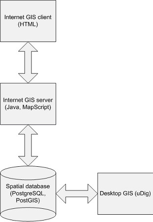
Reliable access to basic services can improve a community's resilience to HIV/AIDS. Accordingly, work is being done to upgrade the physical infrastructure in affected areas, often employing a strategy of decentralised service provision. Spatial characteristics are one of the major determinants in implementing services, even in the smaller municipal areas, and good quality spatial information is needed to inform decision making processes. However, limited funds, technical infrastructure and human resource capacity result in little or no access to spatial information for crucial infrastructure development decisions at local level.This research investigated whether it would be possible to develop a GIS for basic infrastructure planning and management at local level. Given the resource constraints of the local government context, particularly in small municipalities, it was decided that open source software should be used for the prototype system.
The design and development of a prototype system illustrated that it is possible to develop an open source GIS system that can be used within the context of local information management. Usability tests show a high degree of usability for the system, which is important considering the heavy workload and high staff turnover that characterises local government in South Africa. Local infrastructure management stakeholders interviewed in a case study of a South African municipality see the potential for the use of GIS as a communication tool and are generally positive about the use of GIS for these purposes. They note security issues that may arise through the sharing of information, lack of skills and resource constraints as the major barriers to adoption.
The case study shows that spatial information is an identified need at local level. Open source GIS software can be used to develop a system to provide local-level stakeholders with spatial information. However, the suitability of the technology is only a part of the system - there are wider information and management issues which need to be addressed before the implementation of a local-level GIS for infrastructure management can be successful.
可靠地获取基本服务能够提高社区对艾滋病毒/艾滋病的抵御能力。因此,目前正在开展工作以升级受影响地区的实体基础设施,通常采用分散式服务提供策略。空间特征是实施服务的主要决定因素之一,即使在较小的市政区域也是如此,并且需要高质量的空间信息来为决策过程提供依据。然而,资金有限、技术基础设施和人力资源能力不足导致在地方层面进行关键基础设施发展决策时几乎无法获取空间信息。本研究调查了是否有可能开发一个用于地方层面基本基础设施规划和管理的地理信息系统(GIS)。鉴于地方政府环境的资源限制,特别是在小型市政当局中,决定原型系统应使用开源软件。
一个原型系统的设计与开发表明,开发一个可在地方信息管理背景下使用的开源GIS系统是可行的。可用性测试表明该系统具有高度可用性,考虑到南非地方政府工作量大且人员流动率高的特点,这一点很重要。在对南非一个市政当局的案例研究中接受采访的地方基础设施管理利益相关者认为GIS有作为沟通工具的潜力,并且总体上对将GIS用于这些目的持积极态度。他们指出,信息共享可能引发的安全问题、缺乏技能以及资源限制是采用GIS的主要障碍。
该案例研究表明,空间信息是地方层面已确定的需求。开源GIS软件可用于开发一个系统,为地方层面的利益相关者提供空间信息。然而,技术的适用性只是系统的一部分——在成功实施用于基础设施管理的地方层面GIS之前,还有更广泛的信息和管理问题需要解决。