Nagata Takashi, Takamori Ayako, Kimura Yoshinari, Kimura Akio, Hashizume Makoto, Nakahara Shinji
Kyushu University Hospital, Department of Emergency and Critical Care Center, Fukuoka, Japan.
J Trauma Manag Outcomes. 2011 Sep 30;5:11. doi: 10.1186/1752-2897-5-11.
Rapid economic growth in Vietnam over the last decade has led to an increased frequency of road traffic injury (RTI), which now represents one of the leading causes of death in the nation. Various efforts toward injury prevention have not produced a significant decline in the incidence of RTIs. Our study sought to describe the geographic distribution of RTIs in Hanoi, Vietnam and to evaluate the accessibility of trauma centers to those injured in the city.
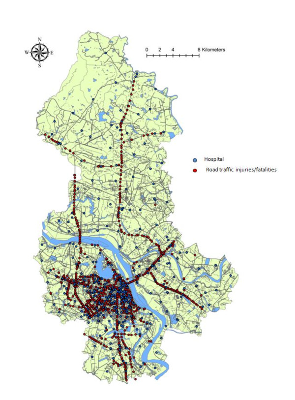
We performed a cross-sectional study using Hanoi city police reports from 2006 to describe the epidemiology of RTIs occurring in Hanoi city. Additionally, we identified geographic patterns and determined the direct distance from injury sites to trauma centers by applying geographical information system (GIS) software. Factors associated with the accessibility of trauma centers were evaluated by multivariate regression analysis.
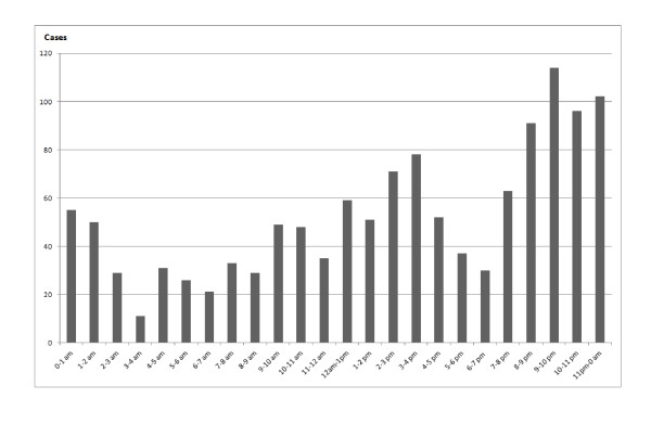
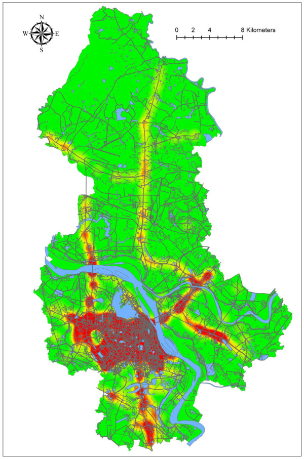
We mapped 1,271 RTIs in Hanoi city. About 40% of RTIs occurred among people 20-29 years of age. Additionally, 63% of RTIs were motorcycle-associated incidents. Two peak times of injury occurrence were observed: 12 am-4 pm and 8 pm-0 am. "Hot spots" of road traffic injuries/fatalities were identified in the city area and on main highways using Kernel density estimation. Interestingly, RTIs occurring along the two north-south main roads were not within easy access of trauma centers. Further, fatal cases, gender and injury mechanism were significantly associated with the distance between injury location and trauma centers.
Geographical patterns of RTIs in Hanoi city differed by gender, time, and injury mechanism; such information may be useful for injury prevention. Specifically, RTIs occurring along the two north-south main roads have lower accessibility to trauma centers, thus an emergency medical service system should be established.
过去十年间,越南经济快速增长,导致道路交通伤害(RTI)的发生频率增加,目前RTI已成为该国主要死因之一。为预防伤害所做的各种努力并未使RTI的发病率显著下降。我们的研究旨在描述越南河内市RTI的地理分布,并评估创伤中心对该市受伤者的可及性。
我们进行了一项横断面研究,使用河内市2006年的警方报告来描述河内市发生的RTI的流行病学情况。此外,我们通过应用地理信息系统(GIS)软件确定了地理模式,并确定了受伤地点到创伤中心的直线距离。通过多变量回归分析评估与创伤中心可及性相关的因素。
我们绘制了河内市1271起RTI的地图。约40%的RTI发生在20至29岁的人群中。此外,63%的RTI是与摩托车相关的事故。观察到两个受伤高峰时段:上午12点至下午4点和晚上8点至凌晨0点。使用核密度估计法在市区和主要公路上确定了道路交通伤害/死亡的“热点”地区。有趣的是,沿两条南北向主要道路发生的RTI不易到达创伤中心。此外,死亡病例、性别和受伤机制与受伤地点和创伤中心之间的距离显著相关。
河内市RTI的地理模式因性别、时间和受伤机制而异;此类信息可能有助于预防伤害。具体而言,沿两条南北向主要道路发生的RTI到达创伤中心的可及性较低,因此应建立紧急医疗服务系统。