State Key Laboratory of Marine Geology, Tongji University, Shanghai 200092, China.
Sensors (Basel). 2012;12(6):7778-803. doi: 10.3390/s120607778. Epub 2012 Jun 7.
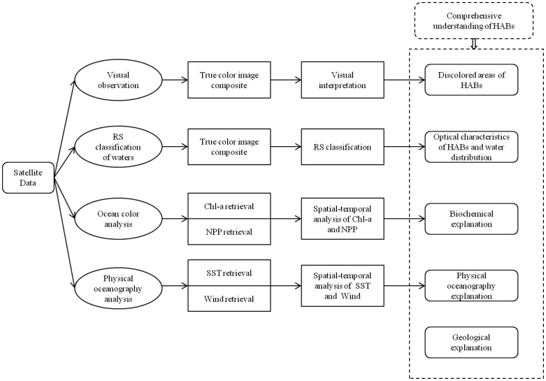
Harmful algal blooms (HABs) are severe ecological disasters threatening aquatic systems throughout the World, which necessitate scientific efforts in detecting and monitoring them. Compared with traditional in situ point observations, satellite remote sensing is considered as a promising technique for studying HABs due to its advantages of large-scale, real-time, and long-term monitoring. The present review summarizes the suitability of current satellite data sources and different algorithms for detecting HABs. It also discusses the spatial scale issue of HABs. Based on the major problems identified from previous literature, including the unsystematic understanding of HABs, the insufficient incorporation of satellite remote sensing, and a lack of multiple oceanographic explanations of the mechanisms causing HABs, this review also attempts to provide a comprehensive understanding of the complicated mechanism of HABs impacted by multiple oceanographic factors. A potential synthesized framework can be established by combining multiple accessible satellite remote sensing approaches including visual interpretation, spectra analysis, parameters retrieval and spatial-temporal pattern analysis. This framework aims to lead to a systematic and comprehensive monitoring of HABs based on satellite remote sensing from multiple oceanographic perspectives.
有害藻华 (HABs) 是威胁全球水生系统的严重生态灾害,因此需要进行科学研究来检测和监测它们。与传统的现场点观测相比,卫星遥感被认为是研究 HABs 的一种很有前途的技术,因为它具有大规模、实时和长期监测的优势。本综述总结了当前卫星数据源和不同算法检测 HABs 的适用性。它还讨论了 HABs 的空间尺度问题。基于从以前的文献中确定的主要问题,包括对 HABs 的系统理解不足、卫星遥感的应用不足以及对导致 HABs 的机制缺乏多种海洋学解释,本综述还试图提供对受多种海洋学因素影响的 HABs 复杂机制的全面理解。通过结合多种可访问的卫星遥感方法,包括目视解释、光谱分析、参数反演和时空模式分析,可以建立一个潜在的综合框架。该框架旨在基于卫星遥感从多个海洋学角度对 HABs 进行系统和全面的监测。