• 文献检索
  • 文档翻译
  • 深度研究
  • 学术资讯
  • Suppr Zotero 插件Zotero 插件
  • 邀请有礼
  • 套餐&价格
  • 历史记录
应用&插件
Suppr Zotero 插件Zotero 插件浏览器插件Mac 客户端Windows 客户端微信小程序
定价
高级版会员购买积分包购买API积分包
服务
文献检索文档翻译深度研究API 文档MCP 服务
关于我们
关于 Suppr公司介绍联系我们用户协议隐私条款
关注我们

Suppr 超能文献

核心技术专利:CN118964589B侵权必究
粤ICP备2023148730 号-1Suppr @ 2026

文献检索

告别复杂PubMed语法,用中文像聊天一样搜索,搜遍4000万医学文献。AI智能推荐,让科研检索更轻松。

立即免费搜索

文件翻译

保留排版,准确专业,支持PDF/Word/PPT等文件格式,支持 12+语言互译。

免费翻译文档

深度研究

AI帮你快速写综述,25分钟生成高质量综述,智能提取关键信息,辅助科研写作。

立即免费体验

基于地理信息系统模型的地面救护车院前时间的验证。

A validation of ground ambulance pre-hospital times modeled using geographic information systems.

机构信息

Department of Community Health Sciences, University of Calgary, Calgary, Alberta, Canada.

出版信息

Int J Health Geogr. 2012 Oct 3;11:42. doi: 10.1186/1476-072X-11-42.

DOI:10.1186/1476-072X-11-42
PMID:23033894
原文链接:https://pmc.ncbi.nlm.nih.gov/articles/PMC3527264/
Abstract

BACKGROUND

Evaluating geographic access to health services often requires determining the patient travel time to a specified service. For urgent care, many research studies have modeled patient pre-hospital time by ground emergency medical services (EMS) using geographic information systems (GIS). The purpose of this study was to determine if the modeling assumptions proposed through prior United States (US) studies are valid in a non-US context, and to use the resulting information to provide revised recommendations for modeling travel time using GIS in the absence of actual EMS trip data.

METHODS

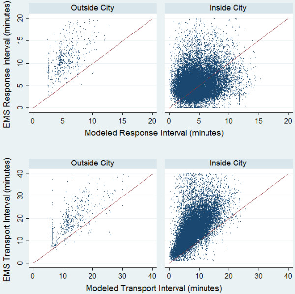
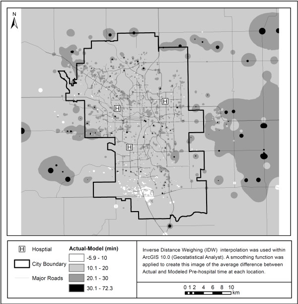
The study sample contained all emergency adult patient trips within the Calgary area for 2006. Each record included four components of pre-hospital time (activation, response, on-scene and transport interval). The actual activation and on-scene intervals were compared with those used in published models. The transport interval was calculated within GIS using the Network Analyst extension of Esri ArcGIS 10.0 and the response interval was derived using previously established methods. These GIS derived transport and response intervals were compared with the actual times using descriptive methods. We used the information acquired through the analysis of the EMS trip data to create an updated model that could be used to estimate travel time in the absence of actual EMS trip records.

RESULTS

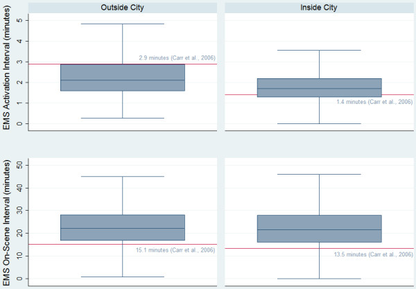
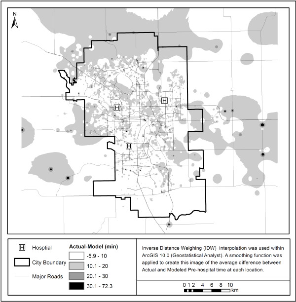
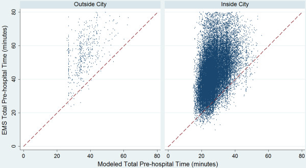
There were 29,765 complete EMS records for scene locations inside the city and 529 outside. The actual median on-scene intervals were longer than the average previously reported by 7-8 minutes. Actual EMS pre-hospital times across our study area were significantly higher than the estimated times modeled using GIS and the original travel time assumptions. Our updated model, although still underestimating the total pre-hospital time, more accurately represents the true pre-hospital time in our study area.

CONCLUSIONS

The widespread use of generalized EMS pre-hospital time assumptions based on US data may not be appropriate in a non-US context. The preference for researchers should be to use actual EMS trip records from the proposed research study area. In the absence of EMS trip data researchers should determine which modeling assumptions more accurately reflect the EMS protocols across their study area.

摘要

背景

评估医疗服务的地理可达性通常需要确定患者到达指定服务的出行时间。对于紧急护理,许多研究使用地理信息系统 (GIS) 通过地面紧急医疗服务 (EMS) 对患者的院前时间进行建模。本研究的目的是确定美国 (US) 之前的研究提出的建模假设在非 US 环境中是否有效,并利用这些信息为在缺乏实际 EMS 行程数据的情况下使用 GIS 建模出行时间提供修订建议。

方法

研究样本包含 2006 年卡尔加里地区所有的急诊成年患者出行记录。每条记录包括院前时间的四个组成部分(激活、响应、现场和运输间隔)。实际的激活和现场间隔与已发表模型中的间隔进行了比较。在 GIS 中使用 Esri ArcGIS 10.0 的 Network Analyst 扩展计算了运输间隔,使用先前建立的方法得出了响应间隔。使用描述性方法比较了这些 GIS 派生的运输和响应间隔与实际时间。我们利用通过分析 EMS 行程数据获得的信息创建了一个更新的模型,可以在缺乏实际 EMS 行程记录的情况下用于估计出行时间。

结果

在城市内部和外部的场景位置,共有 29765 个完整的 EMS 记录。实际的中位数现场间隔比之前报告的平均时间长 7-8 分钟。我们研究区域内的实际 EMS 院前时间明显高于使用 GIS 和原始出行时间假设建模的估计时间。我们的更新模型虽然仍然低估了总院前时间,但更准确地代表了我们研究区域内的真实院前时间。

结论

基于美国数据的广泛使用通用 EMS 院前时间假设在非 US 环境中可能并不合适。研究人员的首选应该是使用拟议研究区域的实际 EMS 行程记录。在缺乏 EMS 行程数据的情况下,研究人员应确定哪些建模假设更能反映整个研究区域的 EMS 协议。

https://cdn.ncbi.nlm.nih.gov/pmc/blobs/8e1d/3527264/679392751357/1476-072X-11-42-5.jpg
https://cdn.ncbi.nlm.nih.gov/pmc/blobs/8e1d/3527264/9bba9540eb8c/1476-072X-11-42-1.jpg
https://cdn.ncbi.nlm.nih.gov/pmc/blobs/8e1d/3527264/7acfdfccb8d3/1476-072X-11-42-2.jpg
https://cdn.ncbi.nlm.nih.gov/pmc/blobs/8e1d/3527264/34c51a3ff404/1476-072X-11-42-3.jpg
https://cdn.ncbi.nlm.nih.gov/pmc/blobs/8e1d/3527264/828a8e5a7c10/1476-072X-11-42-4.jpg
https://cdn.ncbi.nlm.nih.gov/pmc/blobs/8e1d/3527264/679392751357/1476-072X-11-42-5.jpg

相似文献

1
A validation of ground ambulance pre-hospital times modeled using geographic information systems.基于地理信息系统模型的地面救护车院前时间的验证。
Int J Health Geogr. 2012 Oct 3;11:42. doi: 10.1186/1476-072X-11-42.
2
Predicting ambulance time of arrival to the emergency department using global positioning system and Google maps.利用全球定位系统和谷歌地图预测救护车到达急诊科的时间。
Prehosp Emerg Care. 2013 Oct-Dec;17(4):458-65. doi: 10.3109/10903127.2013.811562. Epub 2013 Jul 18.
3
A geographic information system simulation model of EMS: reducing ambulance response time.一个急救医疗服务的地理信息系统模拟模型:缩短救护车响应时间。
Am J Emerg Med. 2004 May;22(3):164-70. doi: 10.1016/j.ajem.2004.02.003.
4
Spatiotemporal access to emergency medical services in Wuhan, China: accounting for scene and transport time intervals.中国武汉紧急医疗服务的时空可达性:考虑现场和运输时间间隔。
Int J Health Geogr. 2020 Nov 26;19(1):52. doi: 10.1186/s12942-020-00249-7.
5
A comparison of actual versus predicted emergency ambulance journey times using generic Geographic Information System software.使用通用地理信息系统软件对实际与预测的紧急救护车行程时间进行比较。
Emerg Med J. 2014 Sep;31(9):758-62. doi: 10.1136/emermed-2012-202246. Epub 2013 Jun 5.
6
Comparing Methodologies for Evaluating Emergency Medical Services Ground Transport Access to Time-critical Emergency Services: A Case Study Using Trauma Center Care.比较评估紧急医疗服务地面交通获取时间关键紧急服务的方法:以创伤中心救治为例的案例研究。
Acad Emerg Med. 2012 Sep;19(9):E1099-108. doi: 10.1111/j.1553-2712.2012.01440.x.
7
The Effect of Ambulance Staffing Models in a Metropolitan, Fire-Based EMS System.大城市基于消防的急救医疗服务系统中救护车人员配备模式的影响
Prehosp Disaster Med. 2017 Apr;32(2):175-179. doi: 10.1017/S1049023X16001539. Epub 2017 Jan 18.
8
A model for the association of the call volume and the unavailable-for-response interval on the delayed ambulance response for out-of-hospital cardiac arrest using a geographic information system.使用地理信息系统建立院外心脏骤停延迟救护车反应的呼入量与无法响应间隔时间的关联模型。
Prehosp Emerg Care. 2010 Oct-Dec;14(4):469-76. doi: 10.3109/10903127.2010.497895.
9
Determining geographic areas and populations with timely access to cardiac catheterization facilities for acute myocardial infarction care in Alberta, Canada.确定加拿大艾伯塔省能够及时使用心脏导管插入设施进行急性心肌梗死治疗的地理区域和人群。
Int J Health Geogr. 2007 Oct 16;6:47. doi: 10.1186/1476-072X-6-47.
10
The Medical Duty Officer: An Attempt to Mitigate the Ambulance At-Hospital Interval.医疗值班官员:缩短救护车到院间隔时间的一次尝试。
West J Emerg Med. 2016 Sep;17(5):662-8. doi: 10.5811/westjem.2016.7.30266. Epub 2016 Aug 23.

引用本文的文献

1
Key challenges in prehospital and emergency care in Indonesia and Malaysia: a survey of frontline clinicians.印度尼西亚和马来西亚院前及急救护理的主要挑战:对一线临床医生的调查。
BMC Res Notes. 2024 Oct 3;17(1):287. doi: 10.1186/s13104-024-06916-3.
2
Effect of urgency level on prehospital emergency transport times: a natural experiment. urgency 对院前急救转运时间的影响:一项自然实验。
Intern Emerg Med. 2024 Mar;19(2):445-453. doi: 10.1007/s11739-023-03501-7. Epub 2023 Dec 20.
3
Identifying the vulnerable regions of emergency medical services based on the three-stage of accessibility: a case study in Xi'an, China.

本文引用的文献

1
Emergency medical services response time and mortality in an urban setting.城市环境中的紧急医疗服务响应时间与死亡率。
Prehosp Emerg Care. 2012 Jan-Mar;16(1):142-51. doi: 10.3109/10903127.2011.614046. Epub 2011 Oct 25.
2
EMS relocation in a rural area using a geographic information system can improve response time to motor vehicle crashes.在农村地区使用地理信息系统进行紧急医疗服务重新部署可以缩短对机动车碰撞事故的响应时间。
J Trauma. 2011 Oct;71(4):1023-6. doi: 10.1097/TA.0b013e318230f6f0.
3
Access to primary percutaneous coronary intervention for ST-segment elevation myocardial infarction in Canada: a geographic analysis.
基于可达性三阶段的急救医疗服务脆弱区域识别:以中国西安为例
Int J Equity Health. 2022 Apr 22;21(1):54. doi: 10.1186/s12939-022-01653-0.
4
Geographic barriers to establishing a successful hospital referral system in rural Madagascar.在马达加斯加农村地区建立成功的医院转诊系统面临地理障碍。
BMJ Glob Health. 2021 Dec;6(12). doi: 10.1136/bmjgh-2021-007145.
5
How prepared is Mozambique to treat COVID-19 patients? A new approach for estimating oxygen service availability, oxygen treatment capacity, and population access to oxygen-ready treatment facilities.莫桑比克做好治疗新冠肺炎患者的准备了吗?一种评估氧气供应服务能力、氧气治疗能力和人群获得备有氧气治疗设施的治疗能力的新方法。
Int J Equity Health. 2021 Apr 6;20(1):90. doi: 10.1186/s12939-021-01403-8.
6
Assessing inequalities in geographical access to emergency medical services in metropolitan Lisbon: a cross-sectional and ecological study.评估大里斯本地区获得紧急医疗服务的地理不平等:一项横断面和生态学研究。
BMJ Open. 2020 Nov 6;10(11):e033777. doi: 10.1136/bmjopen-2019-033777.
7
Expanding the impact of a longstanding Canadian cardiac registry through data linkage: challenges and opportunities.通过数据链接扩大加拿大一个长期心脏登记处的影响:挑战与机遇
Int J Popul Data Sci. 2018 Nov 12;3(3):441. doi: 10.23889/ijpds.v3i3.441.
8
Validating the Global Surgery Geographical Accessibility Indicator: Differences in Modeled Versus Patient-Reported Travel Times.验证全球手术地理可达性指标:模型预测与患者报告旅行时间的差异。
World J Surg. 2020 Jul;44(7):2123-2130. doi: 10.1007/s00268-020-05480-8.
9
Multi-Institutional Multidisciplinary Injury Mortality Investigation in the Civilian Pre-Hospital Environment (MIMIC): a methodology for reliably measuring prehospital time and distance to definitive care.民用院前环境中的多机构多学科损伤死亡率调查(MIMIC):一种可靠测量院前时间和到确定性治疗地点距离的方法。
Trauma Surg Acute Care Open. 2019 Apr 11;4(1):e000309. doi: 10.1136/tsaco-2019-000309. eCollection 2019.
10
Association Between Early Intravenous Fluids Provided by Paramedics and Subsequent In-Hospital Mortality Among Patients With Sepsis.急救人员早期提供的静脉输液与脓毒症患者后续住院死亡率之间的关联。
JAMA Netw Open. 2018 Dec 7;1(8):e185845. doi: 10.1001/jamanetworkopen.2018.5845.
加拿大ST段抬高型心肌梗死患者接受直接经皮冠状动脉介入治疗的情况:一项地理分析。
Open Med. 2010;4(1):e13-21. Epub 2010 Feb 2.
4
Mass casualty modelling: a spatial tool to support triage decision making.批量伤亡建模:一种支持分诊决策制定的空间工具。
Int J Health Geogr. 2011 Jun 10;10:40. doi: 10.1186/1476-072X-10-40.
5
Population density, call-response interval, and survival of out-of-hospital cardiac arrest.人口密度、反应时间和院外心脏骤停的存活率。
Int J Health Geogr. 2011 Apr 14;10:26. doi: 10.1186/1476-072X-10-26.
6
ACCESS: acute cerebrovascular care in emergency stroke systems.ACCESS:急诊卒中系统中的急性脑血管护理
Arch Neurol. 2010 Oct;67(10):1210-8. doi: 10.1001/archneurol.2010.250.
7
On-scene time and outcome after penetrating trauma: an observational study.现场时间和穿透性创伤后的结果:一项观察性研究。
Emerg Med J. 2011 Sep;28(9):797-801. doi: 10.1136/emj.2010.097535. Epub 2010 Oct 9.
8
A model for the association of the call volume and the unavailable-for-response interval on the delayed ambulance response for out-of-hospital cardiac arrest using a geographic information system.使用地理信息系统建立院外心脏骤停延迟救护车反应的呼入量与无法响应间隔时间的关联模型。
Prehosp Emerg Care. 2010 Oct-Dec;14(4):469-76. doi: 10.3109/10903127.2010.497895.
9
Pre-hospital care time intervals among victims of road traffic injuries in Iran. A cross-sectional study.伊朗道路交通伤害受害者的院前急救时间间隔。一项横断面研究。
BMC Public Health. 2010 Jul 9;10:406. doi: 10.1186/1471-2458-10-406.
10
Prehospital care - scoop and run or stay and play?院前急救——抢救后快速离开还是就地展开急救?
Injury. 2009 Nov;40 Suppl 4:S23-6. doi: 10.1016/j.injury.2009.10.033.