Darby Stephen E, Leyland Julian, Kummu Matti, Räsänen Timo A, Lauri Hannu
Geography and Environment, University of Southampton Highfield, Southampton, UK.
Water Resour Res. 2013 Apr;49(4):2146-2163. doi: 10.1002/wrcr.20205. Epub 2013 Apr 25.
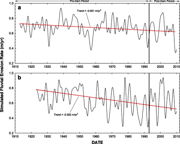
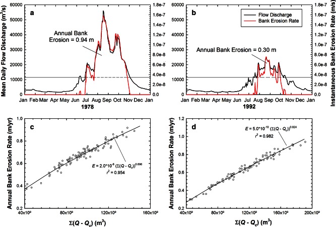
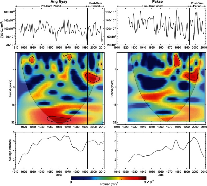
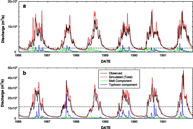
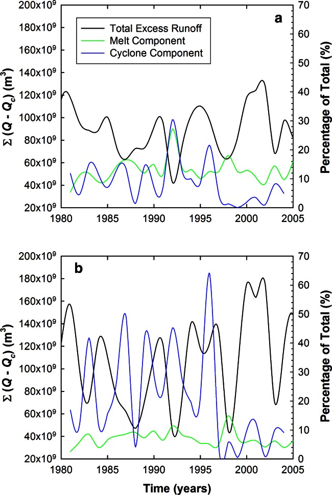
We evaluate links between climate and simulated river bank erosion for one of the world's largest rivers, the Mekong. We employ a process-based model to reconstruct multidecadal time series of bank erosion at study sites within the Mekong's two main hydrological response zones, defining a new parameter, accumulated excess runoff (AER), pertinent to bank erosion. We employ a hydrological model to isolate how snowmelt, tropical storms and monsoon precipitation each contribute to AER and thus modeled bank erosion. Our results show that melt (23.9% at the upstream study site, declining to 11.1% downstream) and tropical cyclones (17.5% and 26.4% at the upstream and downstream sites, respectively) both force significant fractions of bank erosion on the Mekong. We also show (i) small, but significant, declines in AER and hence assumed bank erosion during the 20th century, and; (ii) that significant correlations exist between AER and the Indian Ocean Dipole (IOD) and El Niño Southern Oscillation (ENSO). Of these modes of climate variability, we find that IOD events exert a greater control on simulated bank erosion than ENSO events; but the influences of both ENSO and IOD when averaged over several decades are found to be relatively weak. However, importantly, relationships between ENSO, IOD, and AER and hence inferred river bank erosion are not time invariant. Specifically, we show that there is an intense and prolonged epoch of strong coherence between ENSO and AER from the early 1980s to present, such that in recent decades derived Mekong River bank erosion has been more strongly affected by ENSO.
我们评估了世界上最大的河流之一湄公河的气候与模拟河岸侵蚀之间的联系。我们采用了一个基于过程的模型来重建湄公河两个主要水文响应区内研究地点的数十年河岸侵蚀时间序列,定义了一个与河岸侵蚀相关的新参数——累积过量径流(AER)。我们使用一个水文模型来分离融雪、热带风暴和季风降水对AER的贡献,从而模拟河岸侵蚀。我们的结果表明,融雪(上游研究地点为23.9%,下游降至11.1%)和热带气旋(上游和下游地点分别为17.5%和26.4%)都导致了湄公河相当一部分的河岸侵蚀。我们还表明:(i)在20世纪,AER以及由此假定的河岸侵蚀出现了虽小但显著的下降;(ii)AER与印度洋偶极子(IOD)和厄尔尼诺南方涛动(ENSO)之间存在显著相关性。在这些气候变化模式中,我们发现IOD事件对模拟河岸侵蚀的控制作用比ENSO事件更大;但ENSO和IOD在几十年间的平均影响相对较弱。然而,重要的是,ENSO、IOD与AER之间的关系以及由此推断的河岸侵蚀并非一成不变。具体而言,我们表明,从20世纪80年代初至今,ENSO与AER之间存在一个强烈且持久的高度相干时期,因此在最近几十年里,湄公河岸侵蚀受ENSO的影响更为强烈。