Conservation Science Partners, Inc., Truckee, California, United States of America ; Lab of Landscape Ecology and Conservation Biology, School of Earth Sciences and Environmental Sustainability, Northern Arizona University, Flagstaff, Arizona, United States of America.
Department of Fish, Wildlife and Conservation Ecology, New Mexico State University, Las Cruces, New Mexico, United States of America.
PLoS One. 2013 Dec 18;8(12):e81898. doi: 10.1371/journal.pone.0081898. eCollection 2013.
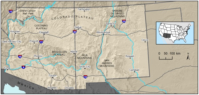
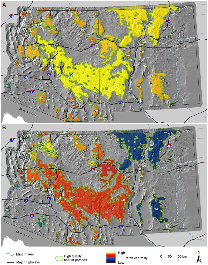
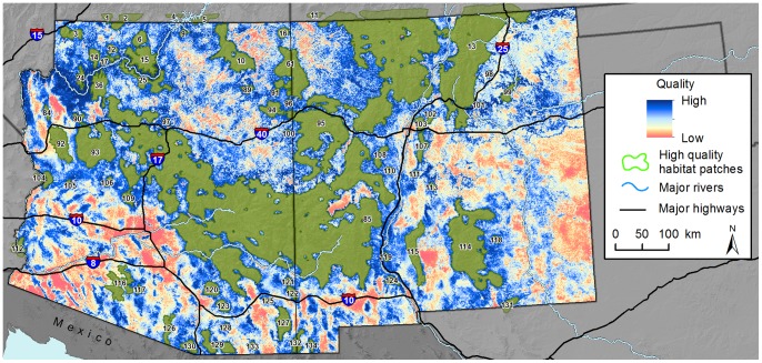
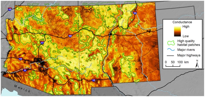
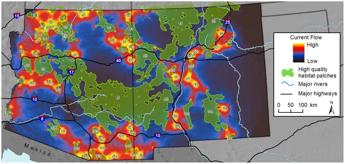
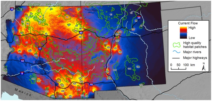
The impact of landscape changes on the quality and connectivity of habitats for multiple wildlife species is of global conservation concern. In the southwestern United States, pumas (Puma concolor) are a well distributed and wide-ranging large carnivore that are sensitive to loss of habitat and to the disruption of pathways that connect their populations. We used an expert-based approach to define and derive variables hypothesized to influence the quality, location, and permeability of habitat for pumas within an area encompassing the entire states of Arizona and New Mexico. Survey results indicated that the presence of woodland and forest cover types, rugged terrain, and canyon bottom and ridgeline topography were expected to be important predictors of both high quality habitat and heightened permeability. As road density, distance to water, or human population density increased, the quality and permeability of habitats were predicted to decline. Using these results, we identified 67 high quality patches across the study area, and applied concepts from electronic circuit theory to estimate regional patterns of connectivity among these patches. Maps of current flow among individual pairs of patches highlighted possible pinch points along two major interstate highways. Current flow summed across all pairs of patches highlighted areas important for keeping the entire network connected, regardless of patch size. Cumulative current flow was highest in Arizona north of the Colorado River and around Grand Canyon National Park, and in the Sky Islands region owing to the many small habitat patches present. Our outputs present a first approximation of habitat quality and connectivity for dispersing pumas in the southwestern United States. Map results can be used to help target finer-scaled analyses in support of planning efforts concerned with the maintenance of puma metapopulation structure, as well as the protection of landscape features that facilitate the dispersal process.
景观变化对多种野生动物物种栖息地质量和连通性的影响是全球保护关注的焦点。在美国西南部,美洲狮(Puma concolor)分布广泛,活动范围广泛,是一种对栖息地丧失和连接它们种群的通道中断敏感的大型食肉动物。我们使用基于专家的方法来定义和推导变量,这些变量假设会影响包括亚利桑那州和新墨西哥州在内的整个地区内美洲狮栖息地的质量、位置和渗透性。调查结果表明,林地和森林覆盖类型、崎岖地形以及峡谷底部和山脊地形的存在预计将是高质量栖息地和高渗透性的重要预测指标。随着道路密度、到水的距离或人口密度的增加,栖息地的质量和渗透性预计会下降。利用这些结果,我们在研究区域内确定了 67 个高质量斑块,并应用电子电路理论的概念来估计这些斑块之间的连通性的区域模式。个体斑块之间电流流动的地图突出了两条主要州际公路沿线的可能瓶颈点。所有斑块对之间的电流总和突出了保持整个网络连接的重要区域,而不管斑块大小如何。亚利桑那州科罗拉多河北部和大峡谷国家公园周围以及由于存在许多小的栖息地斑块,天空岛屿地区的累积电流最高。我们的输出结果提供了美国西南部扩散美洲狮栖息地质量和连通性的初步近似值。地图结果可用于帮助确定更精细的分析目标,以支持与维持美洲狮复合种群结构以及保护促进扩散过程的景观特征有关的规划工作。