Schut Antonius G T, Wardell-Johnson Grant W, Yates Colin J, Keppel Gunnar, Baran Ireneusz, Franklin Steven E, Hopper Stephen D, Van Niel Kimberley P, Mucina Ladislav, Byrne Margaret
Department of Spatial Sciences, Curtin University, Bentley, Western Australia, Australia ; Curtin Institute for Biodiversity and Climate, Curtin University, Bentley, Western Australia, Australia.
Curtin Institute for Biodiversity and Climate, Curtin University, Bentley, Western Australia, Australia.
PLoS One. 2014 Jan 8;9(1):e82778. doi: 10.1371/journal.pone.0082778. eCollection 2014.
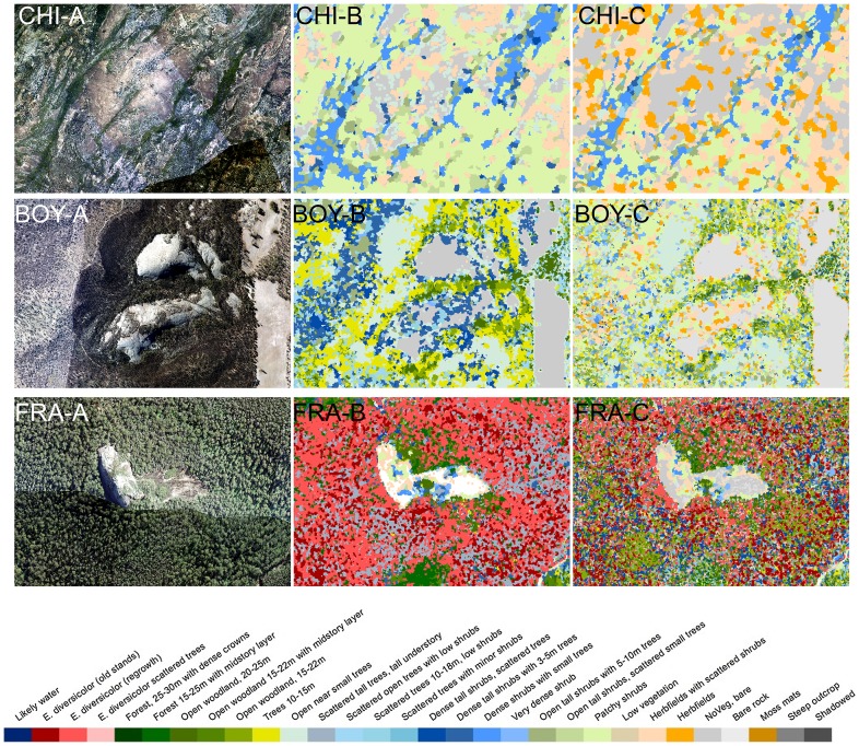
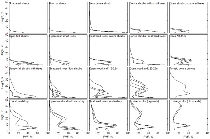
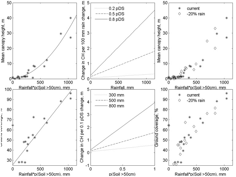
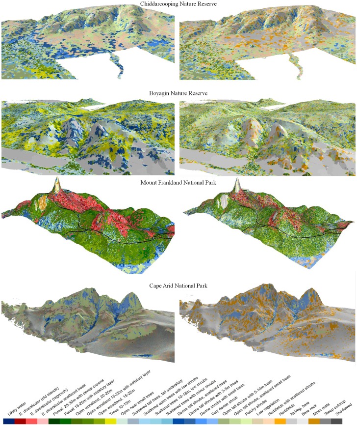
Identification of refugia is an increasingly important adaptation strategy in conservation planning under rapid anthropogenic climate change. Granite outcrops (GOs) provide extraordinary diversity, including a wide range of taxa, vegetation types and habitats in the Southwest Australian Floristic Region (SWAFR). However, poor characterization of GOs limits the capacity of conservation planning for refugia under climate change. A novel means for the rapid identification of potential refugia is presented, based on the assessment of local-scale environment and vegetation structure in a wider region. This approach was tested on GOs across the SWAFR. Airborne discrete return Light Detection And Ranging (LiDAR) data and Red Green and Blue (RGB) imagery were acquired. Vertical vegetation profiles were used to derive 54 structural classes. Structural vegetation types were described in three areas for supervised classification of a further 13 GOs across the region. Habitat descriptions based on 494 vegetation plots on and around these GOs were used to quantify relationships between environmental variables, ground cover and canopy height. The vegetation surrounding GOs is strongly related to structural vegetation types (Kappa = 0.8) and to its spatial context. Water gaining sites around GOs are characterized by taller and denser vegetation in all areas. The strong relationship between rainfall, soil-depth, and vegetation structure (R(2) of 0.8-0.9) allowed comparisons of vegetation structure between current and future climate. Significant shifts in vegetation structural types were predicted and mapped for future climates. Water gaining areas below granite outcrops were identified as important putative refugia. A reduction in rainfall may be offset by the occurrence of deeper soil elsewhere on the outcrop. However, climate change interactions with fire and water table declines may render our conclusions conservative. The LiDAR-based mapping approach presented enables the integration of site-based biotic assessment with structural vegetation types for the rapid delineation and prioritization of key refugia.
在快速的人为气候变化背景下,识别避难所是保护规划中一项日益重要的适应策略。花岗岩露头(GOs)具有非凡的多样性,包括澳大利亚西南部植物区系(SWAFR)中的多种分类群、植被类型和栖息地。然而,对GOs的特征描述不足限制了气候变化下避难所保护规划的能力。本文提出了一种基于对更广泛区域内局部尺度环境和植被结构评估的快速识别潜在避难所的新方法。该方法在SWAFR的GOs上进行了测试。获取了机载离散回波激光雷达(LiDAR)数据和红、绿、蓝(RGB)图像。利用垂直植被剖面得出54种结构类别。在三个区域描述了结构植被类型,以便对该区域另外13个GOs进行监督分类。基于这些GOs及其周围494个植被样地的栖息地描述,用于量化环境变量、地被物和冠层高度之间的关系。GOs周围的植被与结构植被类型(卡帕系数=0.8)及其空间背景密切相关。GOs周围的集水区域在所有区域都具有更高、更密集的植被特征。降雨、土壤深度和植被结构之间的强相关性(R²为0.8 - 0.9)使得能够比较当前和未来气候下的植被结构。预测并绘制了未来气候下植被结构类型的显著变化。花岗岩露头下方的集水区域被确定为重要的假定避难所。降雨减少可能会被露头其他地方更深层土壤的出现所抵消。然而,气候变化与火灾和地下水位下降的相互作用可能使我们的结论较为保守。本文提出的基于LiDAR的绘图方法能够将基于实地的生物评估与结构植被类型相结合,以便快速划定关键避难所并确定其优先级。