• 文献检索
  • 文档翻译
  • 深度研究
  • 学术资讯
  • Suppr Zotero 插件Zotero 插件
  • 邀请有礼
  • 套餐&价格
  • 历史记录
应用&插件
Suppr Zotero 插件Zotero 插件浏览器插件Mac 客户端Windows 客户端微信小程序
定价
高级版会员购买积分包购买API积分包
服务
文献检索文档翻译深度研究API 文档MCP 服务
关于我们
关于 Suppr公司介绍联系我们用户协议隐私条款
关注我们

Suppr 超能文献

核心技术专利:CN118964589B侵权必究
粤ICP备2023148730 号-1Suppr @ 2026

文献检索

告别复杂PubMed语法,用中文像聊天一样搜索,搜遍4000万医学文献。AI智能推荐,让科研检索更轻松。

立即免费搜索

文件翻译

保留排版,准确专业,支持PDF/Word/PPT等文件格式,支持 12+语言互译。

免费翻译文档

深度研究

AI帮你快速写综述,25分钟生成高质量综述,智能提取关键信息,辅助科研写作。

立即免费体验

基于水平集方法利用遥感数据自动提取烧伤瘢痕的研究。

Study of burn scar extraction automatically based on level set method using remote sensing data.

作者信息

Liu Yang, Dai Qin, Liu Jianbo, Liu ShiBin, Yang Jin

机构信息

Institute of Remote Sensing and Digital Earth, Chinese Academy of Sciences, Beijinng, China ; University of Chinese Academy of Sciences, Beijing, China.

Institute of Remote Sensing and Digital Earth, Chinese Academy of Sciences, Beijinng, China.

出版信息

PLoS One. 2014 Feb 4;9(2):e87480. doi: 10.1371/journal.pone.0087480. eCollection 2014.

DOI:10.1371/journal.pone.0087480
PMID:24503563
原文链接:https://pmc.ncbi.nlm.nih.gov/articles/PMC3913612/
Abstract

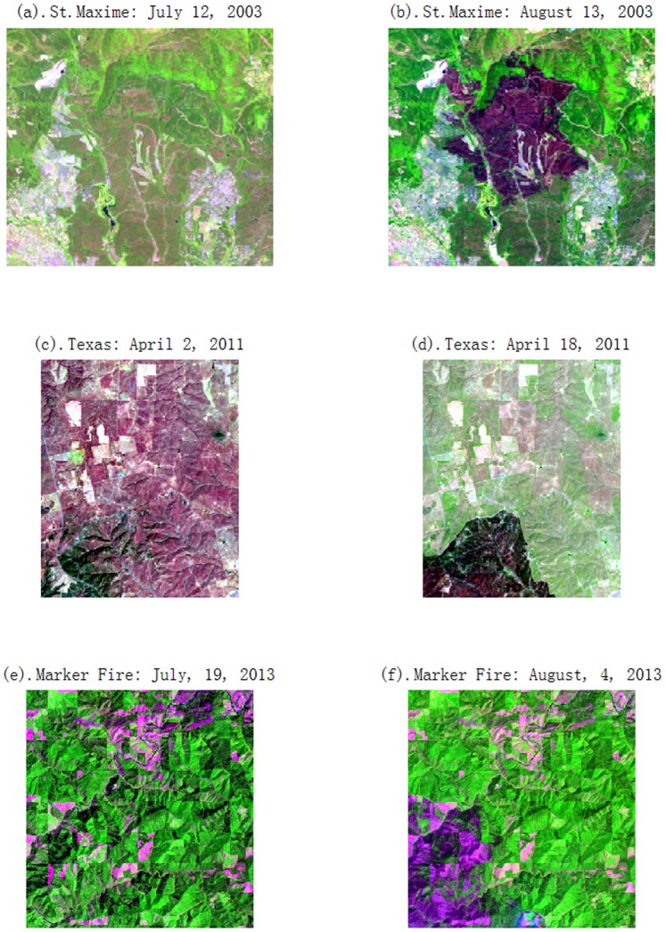
Burn scar extraction using remote sensing data is an efficient way to precisely evaluate burn area and measure vegetation recovery. Traditional burn scar extraction methodologies have no well effect on burn scar image with blurred and irregular edges. To address these issues, this paper proposes an automatic method to extract burn scar based on Level Set Method (LSM). This method utilizes the advantages of the different features in remote sensing images, as well as considers the practical needs of extracting the burn scar rapidly and automatically. This approach integrates Change Vector Analysis (CVA), Normalized Difference Vegetation Index (NDVI) and the Normalized Burn Ratio (NBR) to obtain difference image and modifies conventional Level Set Method Chan-Vese (C-V) model with a new initial curve which results from a binary image applying K-means method on fitting errors of two near-infrared band images. Landsat 5 TM and Landsat 8 OLI data sets are used to validate the proposed method. Comparison with conventional C-V model, OSTU algorithm, Fuzzy C-mean (FCM) algorithm are made to show that the proposed approach can extract the outline curve of fire burn scar effectively and exactly. The method has higher extraction accuracy and less algorithm complexity than that of the conventional C-V model.

摘要

利用遥感数据提取烧伤疤痕是精确评估烧伤面积和测量植被恢复情况的有效方法。传统的烧伤疤痕提取方法对边缘模糊且不规则的烧伤疤痕图像效果不佳。为了解决这些问题,本文提出了一种基于水平集方法(LSM)的烧伤疤痕自动提取方法。该方法利用了遥感图像中不同特征的优势,并考虑了快速自动提取烧伤疤痕的实际需求。该方法整合了变化向量分析(CVA)、归一化植被指数(NDVI)和归一化烧伤比(NBR)以获得差异图像,并使用一种新的初始曲线修改传统的水平集方法Chan-Vese(C-V)模型,该初始曲线来自于对两个近红外波段图像的拟合误差应用K均值方法得到的二值图像。利用Landsat 5 TM和Landsat 8 OLI数据集对所提方法进行验证。与传统C-V模型、OSTU算法、模糊C均值(FCM)算法进行比较,结果表明所提方法能够有效、准确地提取火烧烧伤疤痕的轮廓曲线。该方法比传统C-V模型具有更高的提取精度和更低的算法复杂度。

https://cdn.ncbi.nlm.nih.gov/pmc/blobs/e9f9/3913612/74f8b1202be2/pone.0087480.g008.jpg
https://cdn.ncbi.nlm.nih.gov/pmc/blobs/e9f9/3913612/937bd3a02ee2/pone.0087480.g001.jpg
https://cdn.ncbi.nlm.nih.gov/pmc/blobs/e9f9/3913612/0cb231c42fee/pone.0087480.g002.jpg
https://cdn.ncbi.nlm.nih.gov/pmc/blobs/e9f9/3913612/b3b6d1c25b97/pone.0087480.g003.jpg
https://cdn.ncbi.nlm.nih.gov/pmc/blobs/e9f9/3913612/0506352a644a/pone.0087480.g004.jpg
https://cdn.ncbi.nlm.nih.gov/pmc/blobs/e9f9/3913612/ad8560c5e836/pone.0087480.g005.jpg
https://cdn.ncbi.nlm.nih.gov/pmc/blobs/e9f9/3913612/a678374c84cf/pone.0087480.g006.jpg
https://cdn.ncbi.nlm.nih.gov/pmc/blobs/e9f9/3913612/50036869c2ac/pone.0087480.g007.jpg
https://cdn.ncbi.nlm.nih.gov/pmc/blobs/e9f9/3913612/74f8b1202be2/pone.0087480.g008.jpg

相似文献

1
Study of burn scar extraction automatically based on level set method using remote sensing data.基于水平集方法利用遥感数据自动提取烧伤瘢痕的研究。
PLoS One. 2014 Feb 4;9(2):e87480. doi: 10.1371/journal.pone.0087480. eCollection 2014.
2
Predicting grain protein content of field-grown winter wheat with satellite images and partial least square algorithm.利用卫星图像和偏最小二乘法算法预测田间冬小麦的籽粒蛋白质含量。
PLoS One. 2020 Mar 11;15(3):e0228500. doi: 10.1371/journal.pone.0228500. eCollection 2020.
3
Potentials and limitations of remote fire monitoring in protected areas.远程火灾监测在保护区中的潜力和局限性。
Sci Total Environ. 2018 Mar;616-617:1347-1355. doi: 10.1016/j.scitotenv.2017.10.182. Epub 2017 Nov 6.
4
Determining relative contributions of vegetation and topography to burn severity from LANDSAT imagery.利用 LANDSAT 图像确定植被和地形对火烧强度的相对贡献。
Environ Manage. 2013 Oct;52(4):821-36. doi: 10.1007/s00267-013-0128-3. Epub 2013 Jul 26.
5
Estimation of rice phenology date using integrated HJ-1 CCD and Landsat-8 OLI vegetation indices time-series images.利用HJ-1 CCD和Landsat-8 OLI植被指数时间序列影像估算水稻物候期日期
J Zhejiang Univ Sci B. 2015 Oct;16(10):832-44. doi: 10.1631/jzus.B1500087.
6
Temporal variability of forest fires in eastern Amazonia.亚马孙东部森林火灾的时间变化性。
Ecol Appl. 2011 Oct;21(7):2397-412. doi: 10.1890/10-1168.1.
7
An STP-HSI index method for urban built-up area extraction based on multi-source remote sensing data.一种基于多源遥感数据的城市建成区提取的STP-HSI指数方法。
R Soc Open Sci. 2022 Nov 23;9(11):220597. doi: 10.1098/rsos.220597. eCollection 2022 Nov.
8
Assessment of some remote sensing techniques used to detect land use/land cover changes in South-East Transilvania, Romania.评估罗马尼亚东南部特兰西瓦尼亚一些用于探测土地利用/土地覆盖变化的遥感技术。
Environ Monit Assess. 2014 May;186(5):2685-99. doi: 10.1007/s10661-013-3571-y. Epub 2013 Dec 10.
9
Fire and burn severity assessment: Calibration of Relative Differenced Normalized Burn Ratio (RdNBR) with field data.火灾和燃烧严重程度评估:用实地数据对相对差分归一化燃烧比(RdNBR)进行校准。
J Environ Manage. 2019 Apr 1;235:342-349. doi: 10.1016/j.jenvman.2019.01.077. Epub 2019 Jan 29.
10
Remote sensing of suspended solids concentration in a reservoir with frequent wildland fires on its watershed.流域内经常发生野火的水库悬浮固体浓度的遥感。
Water Sci Technol. 2013;67(1):217-23. doi: 10.2166/wst.2012.560.

引用本文的文献

1
Mapping and Tracking Forest Burnt Areas in the Indio Maiz Biological Reserve Using Sentinel-3 SLSTR and VIIRS-DNB Imagery.利用哨兵 3 SLSTR 和 VIIRS-DNB 图像绘制和跟踪印地欧玉米生物保护区的森林燃烧区。
Sensors (Basel). 2019 Dec 9;19(24):5423. doi: 10.3390/s19245423.

本文引用的文献

1
Active contours without edges.无边缘活动轮廓。
IEEE Trans Image Process. 2001;10(2):266-77. doi: 10.1109/83.902291.