Vaglio Laurin Gaia, Cheung-Wai Chan Jonathan, Chen Qi, Lindsell Jeremy A, Coomes David A, Guerriero Leila, Del Frate Fabio, Miglietta Franco, Valentini Riccardo
Impacts on Agriculture, Forest, and Natural Ecosystems Division, Euro-Mediterranean Center on Climate Change, Viterbo, Italy; Department of Civil Engineering and Computer Sciences Engineering, Tor Vergata University, Rome, Italy.
Foxlab, Fondazione Edmund Mach, S. Michele all' Adige, Italy; Department of Electronics and Informatics, Vrije Universiteit Brussel, Brussels, Belgium.
PLoS One. 2014 Jun 17;9(6):e97910. doi: 10.1371/journal.pone.0097910. eCollection 2014.
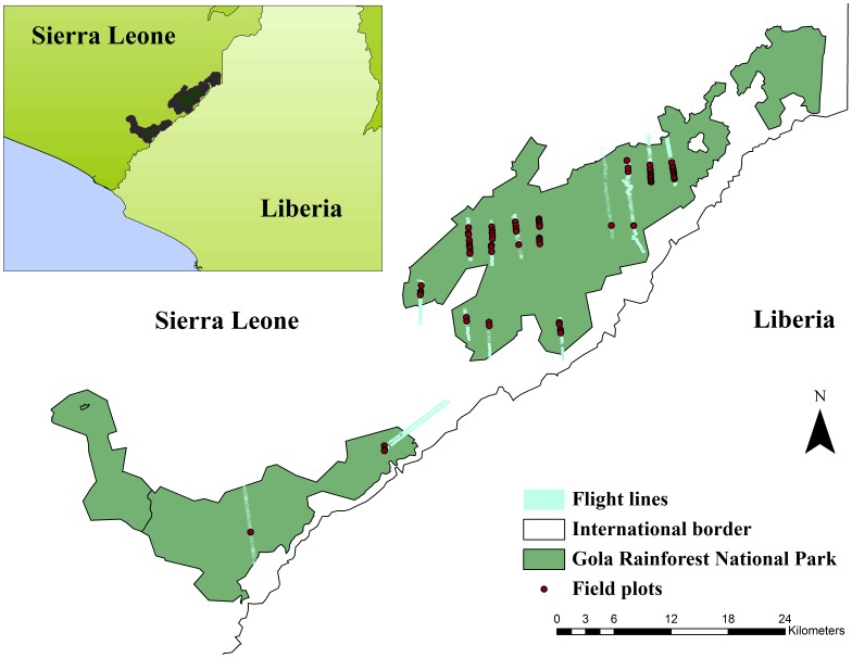
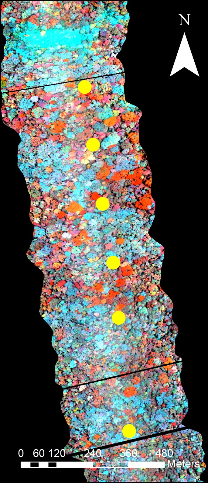
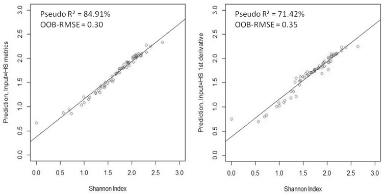
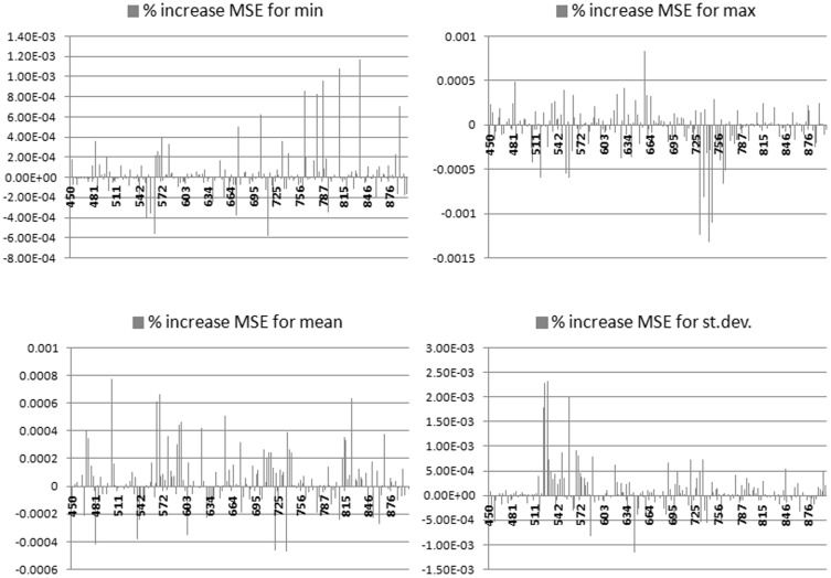
Tropical forests are major repositories of biodiversity, but are fast disappearing as land is converted to agriculture. Decision-makers need to know which of the remaining forests to prioritize for conservation, but the only spatial information on forest biodiversity has, until recently, come from a sparse network of ground-based plots. Here we explore whether airborne hyperspectral imagery can be used to predict the alpha diversity of upper canopy trees in a West African forest. The abundance of tree species were collected from 64 plots (each 1250 m(2) in size) within a Sierra Leonean national park, and Shannon-Wiener biodiversity indices were calculated. An airborne spectrometer measured reflectances of 186 bands in the visible and near-infrared spectral range at 1 m(2) resolution. The standard deviations of these reflectance values and their first-order derivatives were calculated for each plot from the c. 1250 pixels of hyperspectral information within them. Shannon-Wiener indices were then predicted from these plot-based reflectance statistics using a machine-learning algorithm (Random Forest). The regression model fitted the data well (pseudo-R(2) = 84.9%), and we show that standard deviations of green-band reflectances and infra-red region derivatives had the strongest explanatory powers. Our work shows that airborne hyperspectral sensing can be very effective at mapping canopy tree diversity, because its high spatial resolution allows within-plot heterogeneity in reflectance to be characterized, making it an effective tool for monitoring forest biodiversity over large geographic scales.
热带森林是生物多样性的主要储存库,但随着土地被转为农业用途,它们正在迅速消失。决策者需要知道哪些剩余森林应被优先保护,但直到最近,关于森林生物多样性的唯一空间信息来自稀疏的地面样地网络。在此,我们探讨机载高光谱图像是否可用于预测西非一片森林中上层树冠树木的α多样性。从塞拉利昂一个国家公园内的64个样地(每个样地面积为1250平方米)收集了树种丰度,并计算了香农-维纳生物多样性指数。一台机载光谱仪在1米分辨率下测量了可见光和近红外光谱范围内186个波段的反射率。针对每个样地,从其中约1250个高光谱信息像素计算这些反射率值及其一阶导数的标准差。然后使用机器学习算法(随机森林)根据这些基于样地的反射率统计数据预测香农-维纳指数。回归模型对数据拟合良好(伪R² = 84.9%),并且我们表明绿波段反射率的标准差和红外区域导数具有最强的解释力。我们的工作表明,机载高光谱传感在绘制树冠层树木多样性图谱方面非常有效,因为其高空间分辨率能够表征样地内反射率的异质性,使其成为在大地理尺度上监测森林生物多样性的有效工具。