Chow Clara K, Corsi Daniel J, Lock Karen, Madhavan Manisha, Mackie Pam, Li Wei, Yi Sun, Wang Yang, Swaminathan Sumathi, Lopez-Jaramillo Patricio, Gomez-Arbelaez Diego, Avezum Álvaro, Lear Scott A, Dagenais Gilles, Teo Koon, McKee Martin, Yusuf Salim
Population Health Research Institute, Hamilton Health Sciences, McMaster University, Hamilton, Ontario, Canada; The George Institute for Global Health and Westmead Hospital Sydney Medical School, University of Sydney, Sydney, NSW, Australia.
Population Health Research Institute, Hamilton Health Sciences, McMaster University, Hamilton, Ontario, Canada; Harvard Center for Population & Development Studies, Cambridge, MA, United States of America.
PLoS One. 2014 Nov 4;9(11):e110042. doi: 10.1371/journal.pone.0110042. eCollection 2014.
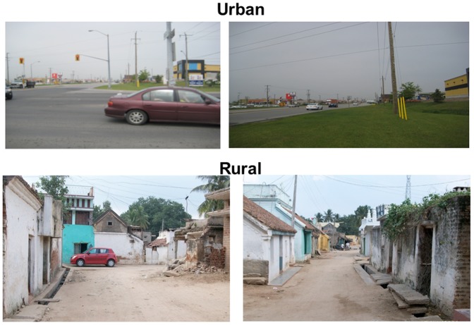
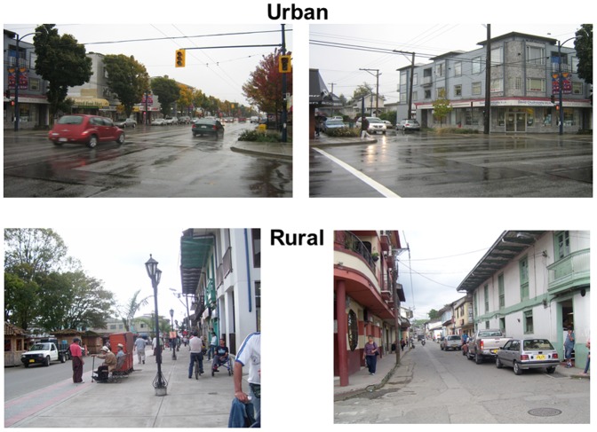
Previous research has shown that environments with features that encourage walking are associated with increased physical activity. Existing methods to assess the built environment using geographical information systems (GIS) data, direct audit or large surveys of the residents face constraints, such as data availability and comparability, when used to study communities in countries in diverse parts of the world. The aim of this study was to develop a method to evaluate features of the built environment of communities using a standard set of photos. In this report we describe the method of photo collection, photo analysis instrument development and inter-rater reliability of the instrument.
METHODS/PRINCIPAL FINDINGS: A minimum of 5 photos were taken per community in 86 communities in 5 countries according to a standard set of instructions from a designated central point of each community by researchers at each site. A standard pro forma derived from reviewing existing instruments to assess the built environment was developed and used to score the characteristics of each community. Photo sets from each community were assessed independently by three observers in the central research office according to the pro forma and the inter-rater reliability was compared by intra-class correlation (ICC). Overall 87% (53 of 60) items had an ICC of ≥ 0.70, 7% (4 of 60) had an ICC between 0.60 and 0.70 and 5% (3 of 60) items had an ICC ≤ 0.50.
CONCLUSIONS/SIGNIFICANCE: Analysis of photos using a standardized protocol as described in this study offers a means to obtain reliable and reproducible information on the built environment in communities in very diverse locations around the world. The collection of the photographic data required minimal training and the analysis demonstrated high reliability for the majority of items of interest.
先前的研究表明,具有鼓励步行特征的环境与增加身体活动相关。利用地理信息系统(GIS)数据、直接审计或对居民进行大规模调查来评估建成环境的现有方法,在用于研究世界不同地区国家的社区时面临诸如数据可用性和可比性等限制。本研究的目的是开发一种使用标准照片集来评估社区建成环境特征的方法。在本报告中,我们描述了照片收集方法、照片分析工具的开发以及该工具的评分者间信度。
方法/主要发现:根据一套标准说明,每个站点的研究人员从每个社区的指定中心点出发,在5个国家的86个社区中,每个社区至少拍摄5张照片。通过回顾现有评估建成环境的工具,开发了一种标准格式并用于对每个社区的特征进行评分。来自每个社区的照片集由中央研究办公室的三名观察者根据该格式独立评估,并通过组内相关系数(ICC)比较评分者间信度。总体而言,87%(60项中的53项)的项目ICC≥0.70,7%(60项中的4项)的项目ICC在0.60至0.70之间,5%(60项中的3项)的项目ICC≤0.50。
结论/意义:如本研究中所述,使用标准化方案对照片进行分析,为获取世界各地非常不同地点社区建成环境的可靠且可重复的信息提供了一种手段。照片数据的收集所需培训极少,并且分析表明大多数感兴趣的项目具有高信度。