Higgins Mark A, Asner Gregory P, Anderson Christopher B, Martin Roberta E, Knapp David E, Tupayachi Raul, Perez Eneas, Elespuru Nydia, Alonso Alfonso
Department of Global Ecology, Carnegie Institution for Science, Stanford, California, United States of America.
Facultad de Ciencias Biológicas, Universidad Nacional de la Amazonía Peruana, Iquitos, Peru.
PLoS One. 2015 Mar 20;10(3):e0119887. doi: 10.1371/journal.pone.0119887. eCollection 2015.
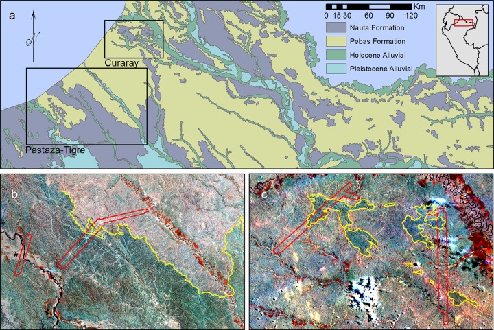
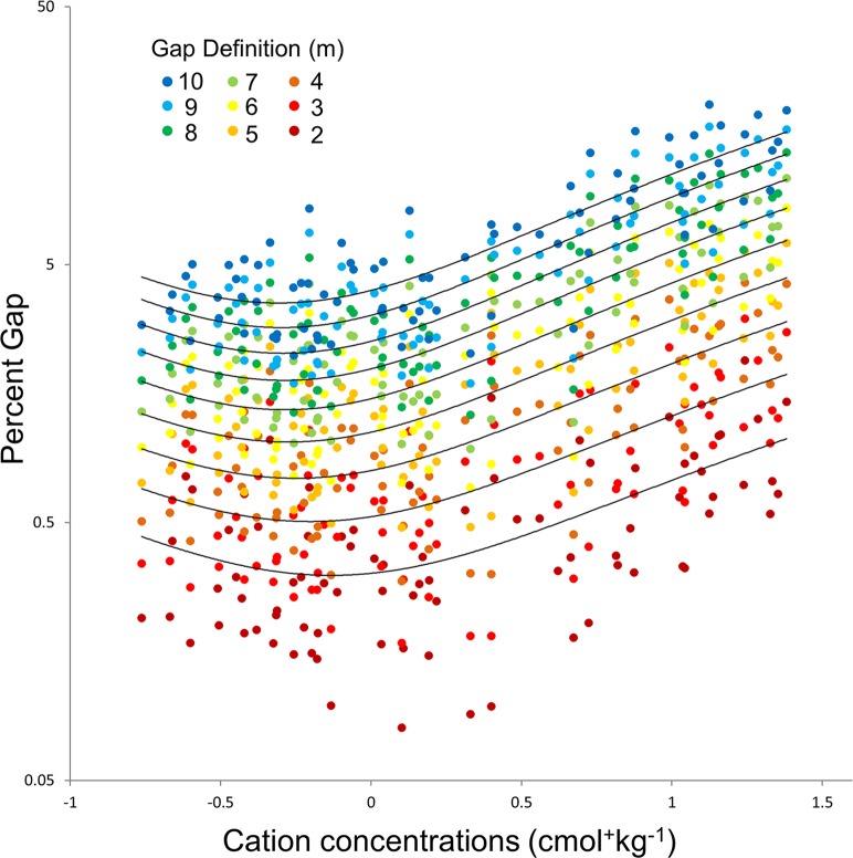
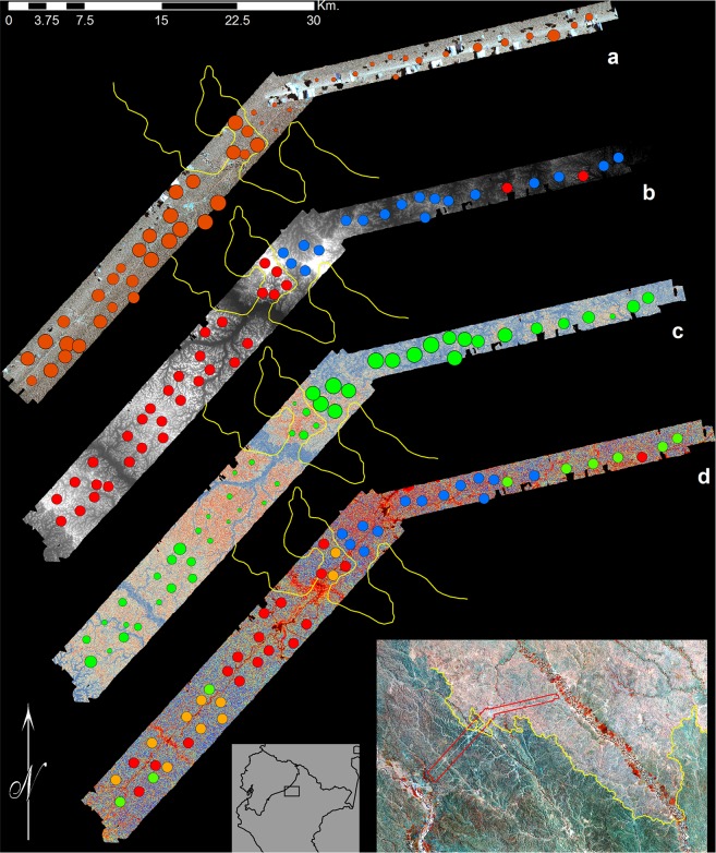
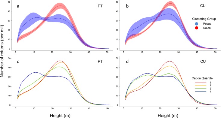
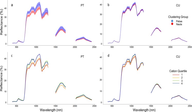
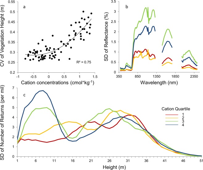
Field studies in Amazonia have found a relationship at continental scales between soil fertility and broad trends in forest structure and function. Little is known at regional scales, however, about how discrete patterns in forest structure or functional attributes map onto underlying edaphic or geological patterns. We collected airborne LiDAR (Light Detection and Ranging) data and VSWIR (Visible to Shortwave Infrared) imaging spectroscopy measurements over 600 km2 of northwestern Amazonian lowland forests. We also established 83 inventories of plant species composition and soil properties, distributed between two widespread geological formations. Using these data, we mapped forest structure and canopy reflectance, and compared them to patterns in plant species composition, soils, and underlying geology. We found that variations in soils and species composition explained up to 70% of variation in canopy height, and corresponded to profound changes in forest vertical profiles. We further found that soils and plant species composition explained more than 90% of the variation in canopy reflectance as measured by imaging spectroscopy, indicating edaphic and compositional control of canopy chemical properties. We last found that soils explained between 30% and 70% of the variation in gap frequency in these forests, depending on the height threshold used to define gaps. Our findings indicate that a relatively small number of edaphic and compositional variables, corresponding to underlying geology, may be responsible for variations in canopy structure and chemistry over large expanses of Amazonian forest.
在亚马孙地区进行的实地研究发现,在大陆尺度上,土壤肥力与森林结构和功能的广泛趋势之间存在关联。然而,在区域尺度上,关于森林结构或功能属性的离散模式如何映射到潜在的土壤或地质模式,人们知之甚少。我们收集了亚马孙西北部低地森林600平方公里区域的机载激光雷达(LiDAR,光探测与测距)数据和可见短波红外(VSWIR)成像光谱测量数据。我们还建立了83个植物物种组成和土壤特性清单,分布在两种广泛的地质构造之间。利用这些数据,我们绘制了森林结构和树冠反射率图,并将它们与植物物种组成、土壤和潜在地质的模式进行比较。我们发现,土壤和物种组成的变化解释了高达70%的树冠高度变化,并对应于森林垂直剖面的深刻变化。我们进一步发现,土壤和植物物种组成解释了成像光谱测量的树冠反射率变化的90%以上,表明土壤和组成对树冠化学性质的控制。我们最后发现,根据用于定义林窗的高度阈值,土壤解释了这些森林林窗频率变化的30%至70%。我们的研究结果表明,与潜在地质相对应的相对较少的土壤和组成变量,可能是亚马孙大片森林树冠结构和化学变化的原因。