Cecchi Giuliano, Paone Massimo, Argilés Herrero Rafael, Vreysen Marc J B, Mattioli Raffaele C
Food and Agriculture Organization of the United Nations (FAO), Sub-regional Office for Eastern Africa, Addis Ababa, Ethiopia.
Food and Agriculture Organization of the United Nations (FAO), Animal Production and Health Division, Rome, Italy.
Parasit Vectors. 2015 May 22;8:284. doi: 10.1186/s13071-015-0898-y.
Tsetse flies (Genus: Glossina) are the sole cyclical vectors of African trypanosomoses. Despite their economic and public health impacts in sub-Saharan Africa, it has been decades since the latest distribution maps at the continental level were produced. The Food and Agriculture Organization of the United Nations is trying to address this shortcoming through the Atlas of tsetse and African animal trypanosomosis.
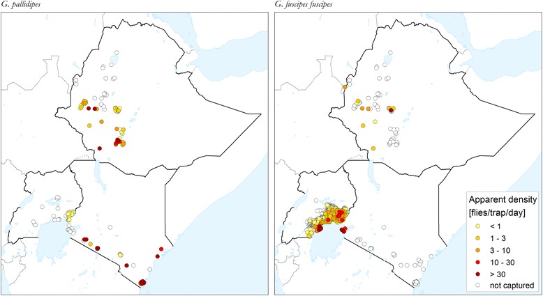
For the tsetse component of the Atlas, a geospatial database is being assembled which comprises information on the distribution and trypanosomal infection of Glossina species. Data are identified through a systematic literature review. Field data collected since January 1990 are included, with a focus on occurrence, apparent density and infection rates of tsetse flies. Mapping is carried out at the level of site/location. For tsetse distribution, the database includes such ancillary information items as survey period, trap type, attractant (if any), number of traps deployed in the site and the duration of trapping (in days). For tsetse infection, the sampling and diagnostic methods are also recorded.
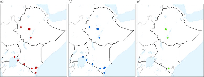
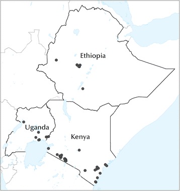
As a proof of concept, tsetse distribution data for three pilot countries (Ethiopia, Kenya and Uganda) were compiled from 130 peer-reviewed publications, which enabled tsetse occurrence to be mapped in 1266 geographic locations. Maps were generated for eight tsetse species (i.e. G. brevipalpis, G. longipennis, G. fuscipes fuscipes, G. tachinoides, G. pallidipes, G. morsitans submorsitans, G. austeni and G. swynnertoni). For tsetse infection rates, data were identified in 25 papers, corresponding to 91 sites.
A methodology was developed to assemble a geo-spatial database on the occurrence, apparent density and trypanosomal infection of Glossina species, which will enable continental maps to be generated. The methodology is suitable for broad brush mapping of all tsetse species of medical and veterinary public health importance. For a few tsetse species, especially those having limited economic importance and circumscribed geographic distribution (e.g. fusca group), recently published information is scanty or non-existent. Tsetse-infested countries can adopt and adapt this approach to compile national Atlases, which ought to draw also on the vast amount of unpublished information.
采采蝇(舌蝇属)是非洲锥虫病的唯一周期性传播媒介。尽管采采蝇在撒哈拉以南非洲地区对经济和公共卫生有影响,但距离上次绘制非洲大陆层面的分布图已有数十年。联合国粮食及农业组织正试图通过《采采蝇与非洲动物锥虫病地图集》来弥补这一缺陷。
对于该地图集的采采蝇部分,正在汇编一个地理空间数据库,其中包含有关舌蝇属物种分布和锥虫感染的信息。通过系统的文献综述来识别数据。纳入自1990年1月以来收集的实地数据,重点是采采蝇的出现情况、表观密度和感染率。绘图在地点/位置层面进行。对于采采蝇分布,数据库包括调查时期、诱捕器类型、引诱剂(如有)、在该地点部署的诱捕器数量以及诱捕持续时间(天数)等辅助信息项。对于采采蝇感染情况,还记录了采样和诊断方法。
作为概念验证,从130篇同行评审出版物中汇编了三个试点国家(埃塞俄比亚、肯尼亚和乌干达)的采采蝇分布数据,从而能够在1266个地理位置绘制采采蝇出现情况图。生成了八种采采蝇物种(即短须舌蝇、长翅舌蝇、fuscipes fuscipes舌蝇、tachinoides舌蝇、淡足舌蝇、submorsitans morsitans舌蝇、奥氏舌蝇和斯氏舌蝇)的地图。对于采采蝇感染率,在25篇论文中识别到了相关数据,对应91个地点。
开发了一种方法来汇编关于舌蝇属物种出现情况、表观密度和锥虫感染的地理空间数据库,这将能够生成非洲大陆地图。该方法适用于对所有具有医学和兽医公共卫生重要性的采采蝇物种进行大致绘图。对于一些采采蝇物种,特别是那些经济重要性有限且地理分布范围受限的物种(如fuscata组),最近发表的信息很少或不存在。采采蝇肆虐的国家可以采用并调整这种方法来编制国家地图集,这也应该利用大量未发表的信息。