• 文献检索
  • 文档翻译
  • 深度研究
  • 学术资讯
  • Suppr Zotero 插件Zotero 插件
  • 邀请有礼
  • 套餐&价格
  • 历史记录
应用&插件
Suppr Zotero 插件Zotero 插件浏览器插件Mac 客户端Windows 客户端微信小程序
定价
高级版会员购买积分包购买API积分包
服务
文献检索文档翻译深度研究API 文档MCP 服务
关于我们
关于 Suppr公司介绍联系我们用户协议隐私条款
关注我们

Suppr 超能文献

核心技术专利:CN118964589B侵权必究
粤ICP备2023148730 号-1Suppr @ 2026

文献检索

告别复杂PubMed语法,用中文像聊天一样搜索,搜遍4000万医学文献。AI智能推荐,让科研检索更轻松。

立即免费搜索

文件翻译

保留排版,准确专业,支持PDF/Word/PPT等文件格式,支持 12+语言互译。

免费翻译文档

深度研究

AI帮你快速写综述,25分钟生成高质量综述,智能提取关键信息,辅助科研写作。

立即免费体验

在资源有限的环境中使用地理信息系统来改善患者获得即时诊断的机会。

Using a geographic information system to enhance patient access to point-of-care diagnostics in a limited-resource setting.

作者信息

Ferguson William J, Kemp Karen, Kost Gerald

机构信息

UC Davis Point of Care Testing Center for Teaching and Research, School of Medicine, University of California, Davis, 3488 Tupper Hall, Davis, CA, 95616, USA.

Spatial Sciences Institute, Dana and Davis Dornsife College of Letters, Arts, and Sciences, University of Southern California, Los Angeles, CA, USA.

出版信息

Int J Health Geogr. 2016 Mar 1;15:10. doi: 10.1186/s12942-016-0037-9.

DOI:10.1186/s12942-016-0037-9
PMID:26932155
原文链接:https://pmc.ncbi.nlm.nih.gov/articles/PMC4774034/
Abstract

BACKGROUND

Rapid and accurate diagnosis drives evidence-based care in health. Point-of-care testing (POCT) aids diagnosis by bringing advanced technologies closer to patients. Health small-world networks are constrained by natural connectivity in the interactions between geography of resources and social forces. Using a geographic information system (GIS) we can understand how populations utilize their health networks, visualize their inefficiencies, and compare alternatives.

METHODS

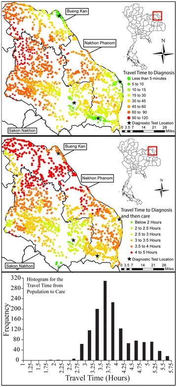
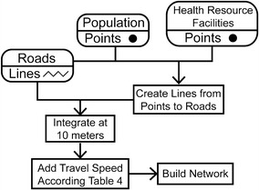
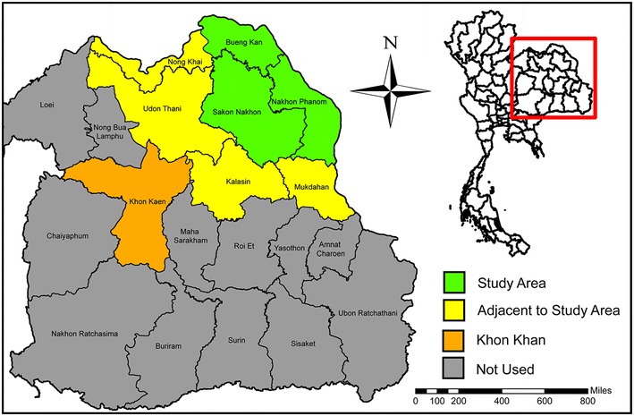
This project focuses on cardiac care resource in rural Isaan, Thailand. A health care access analysis was created using ArcGIS Network Analyst 10.1 from data representing aggregated population, roads, health resource facilities, and diagnostic technologies. The analysis quantified cardiac health care access and identified ways to improve it using both widespread and resource-limited strategies.

RESULTS

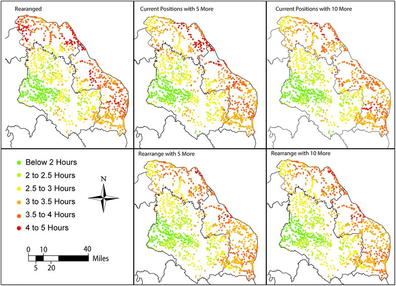
Results indicated that having diagnostic technologies closer to populations streamlines critical care paths. GIS allowed us to compare the effectiveness of the implementation strategies and put into perspective the benefits of adopting rapid POCT within health networks.

CONCLUSIONS

Geospatial analyses derive high impact by improving alternative diagnostic placement strategies in limited-resource settings and by revealing deficiencies in health care access pathways. Additionally, the GIS provides a platform for comparing relative costs, assessing benefits, and improving outcomes. This approach can be implemented effectively by health ministries seeking to enhance cardiac care despite limited resources.

摘要

背景

快速准确的诊断推动着基于证据的医疗保健。即时检验(POCT)通过将先进技术带到患者身边来辅助诊断。健康小世界网络在资源地理与社会力量之间的互动中受到自然连通性的限制。利用地理信息系统(GIS),我们能够了解人群如何利用其健康网络,直观呈现其低效之处,并比较不同方案。

方法

本项目聚焦于泰国伊桑农村地区的心脏护理资源。利用ArcGIS Network Analyst 10.1,根据代表总人口、道路、卫生资源设施及诊断技术的数据,创建了医疗保健可及性分析。该分析量化了心脏保健可及性,并确定了使用广泛和资源有限策略来改善它的方法。

结果

结果表明,让诊断技术更靠近人群可简化重症护理路径。GIS使我们能够比较实施策略的有效性,并正确看待在健康网络中采用快速POCT的益处。

结论

地理空间分析通过在资源有限的环境中改进替代诊断布局策略以及揭示医疗保健可及性途径中的缺陷,产生了重大影响。此外,GIS提供了一个比较相对成本、评估效益和改善结果的平台。卫生部在资源有限的情况下寻求加强心脏护理时,可以有效地实施这种方法。

https://cdn.ncbi.nlm.nih.gov/pmc/blobs/9b26/4774034/0044f3dae55a/12942_2016_37_Fig8_HTML.jpg
https://cdn.ncbi.nlm.nih.gov/pmc/blobs/9b26/4774034/8b64304b2ce8/12942_2016_37_Fig1_HTML.jpg
https://cdn.ncbi.nlm.nih.gov/pmc/blobs/9b26/4774034/aa310e19399e/12942_2016_37_Fig2_HTML.jpg
https://cdn.ncbi.nlm.nih.gov/pmc/blobs/9b26/4774034/e932bcc8bbff/12942_2016_37_Fig3_HTML.jpg
https://cdn.ncbi.nlm.nih.gov/pmc/blobs/9b26/4774034/002e7ffadfaf/12942_2016_37_Fig4_HTML.jpg
https://cdn.ncbi.nlm.nih.gov/pmc/blobs/9b26/4774034/01f607c33f6b/12942_2016_37_Fig5_HTML.jpg
https://cdn.ncbi.nlm.nih.gov/pmc/blobs/9b26/4774034/9fd304113263/12942_2016_37_Fig6_HTML.jpg
https://cdn.ncbi.nlm.nih.gov/pmc/blobs/9b26/4774034/b8af246a2398/12942_2016_37_Fig7_HTML.jpg
https://cdn.ncbi.nlm.nih.gov/pmc/blobs/9b26/4774034/0044f3dae55a/12942_2016_37_Fig8_HTML.jpg

相似文献

1
Using a geographic information system to enhance patient access to point-of-care diagnostics in a limited-resource setting.在资源有限的环境中使用地理信息系统来改善患者获得即时诊断的机会。
Int J Health Geogr. 2016 Mar 1;15:10. doi: 10.1186/s12942-016-0037-9.
2
Geospatial Science and Point-of-Care Testing: Creating Solutions for Population Access, Emergencies, Outbreaks, and Disasters.地理空间科学与即时检验:为人群获取、紧急情况、疫情和灾害创造解决方案。
Front Public Health. 2019 Nov 26;7:329. doi: 10.3389/fpubh.2019.00329. eCollection 2019.
3
Geographic accessibility to public health facilities providing tuberculosis testing services at point-of-care in the upper east region, Ghana.加纳上东部地区提供即时护理结核病检测服务的公共卫生设施的地理可达性。
BMC Public Health. 2019 Jun 10;19(1):718. doi: 10.1186/s12889-019-7052-2.
4
Leveraging community health worker system to map a mountainous rural district in low resource setting: a low-cost approach to expand use of geographic information systems for public health.利用社区卫生工作者系统在资源匮乏地区绘制山区农村地图:一种低成本的方法,以扩大地理信息系统在公共卫生中的应用。
Int J Health Geogr. 2014 Dec 6;13:49. doi: 10.1186/1476-072X-13-49.
5
Bringing the lab bench to the field: Point-of-care testing for enhancing health research and stakeholder engagement in rural/remote, indigenous, and resource-limited contexts.将实验台带到现场:即时检测在农村/偏远地区、原住民和资源有限环境中增强健康研究和利益相关者参与的作用。
Am J Hum Biol. 2022 Nov;34(11):e23808. doi: 10.1002/ajhb.23808. Epub 2022 Sep 27.
6
Evaluating the accessibility and utility of HIV-related point-of-care diagnostics for maternal health in rural South Africa: a study protocol.评估南非农村地区用于孕产妇健康的艾滋病毒即时检测诊断方法的可及性和实用性:一项研究方案
BMJ Open. 2016 Jun 27;6(6):e011155. doi: 10.1136/bmjopen-2016-011155.
7
Using a GIS to support the spatial reorganization of outpatient care services delivery in Italy.利用地理信息系统支持意大利门诊护理服务提供的空间重组。
BMC Health Serv Res. 2018 Nov 22;18(1):883. doi: 10.1186/s12913-018-3642-4.
8
Using geographical information systems for defining the accessibility to health care facilities in Jeddah City, Saudi Arabia.利用地理信息系统确定沙特阿拉伯吉达市医疗保健设施的可及性。
Geospat Health. 2014 Dec 1;8(3):S661-9. doi: 10.4081/gh.2014.295.
9
The future of Cochrane Neonatal.考克兰新生儿协作网的未来。
Early Hum Dev. 2020 Nov;150:105191. doi: 10.1016/j.earlhumdev.2020.105191. Epub 2020 Sep 12.
10
Racial/ethnic minority and low-income hotspots and their geographic proximity to integrated care providers.少数族裔和低收入热点地区及其与综合护理提供者的地理位置邻近程度。
Subst Abuse Treat Prev Policy. 2013 Sep 23;8:34. doi: 10.1186/1747-597X-8-34.

引用本文的文献

1
Updated fine-scale location data for Blantyre district collected using a low-cost approach.使用低成本方法收集的布兰太尔区最新精细尺度位置数据。
Sci Data. 2025 Jul 22;12(1):1275. doi: 10.1038/s41597-025-05605-5.
2
Geographical Access to Point-of-care diagnostic tests for diabetes, anaemia, Hepatitis B, and human immunodeficiency virus in the Bono Region, Ghana.加纳博诺地区针对糖尿病、贫血、乙型肝炎和人类免疫缺陷病毒的即时诊断检测的地理可达性。
BMC Health Serv Res. 2024 Oct 29;24(1):1303. doi: 10.1186/s12913-024-11830-2.
3
Geospatial Point-of-Care Testing Strategies for COVID-19 Resilience in Resource-Poor Settings: Rural Cambodia Field Study.

本文引用的文献

1
The Ebola Spatial Care Path™: Accelerating point-of-care diagnosis, decision making, and community resilience in outbreaks.埃博拉空间护理路径™:在疫情中加速即时诊断、决策制定以及社区恢复力
Am J Disaster Med. 2015 Spring;10(2):121-43. doi: 10.5055/ajdm.2015.0196.
2
Emergency care facility access in rural areas within the golden hour?: Western Cape case study.农村地区在黄金一小时内获得急救设施的情况?:西开普省案例研究。
Int J Health Geogr. 2015 Jan 16;14:5. doi: 10.1186/1476-072X-14-5.
3
Leveraging community health worker system to map a mountainous rural district in low resource setting: a low-cost approach to expand use of geographic information systems for public health.
面向资源匮乏环境下 COVID-19 韧性的地理空间即时检测策略:柬埔寨农村实地研究。
JMIR Public Health Surveill. 2024 Aug 27;10:e47416. doi: 10.2196/47416.
4
Geospatial Demand for Approved Cleft Care in the United States.美国获批唇腭裂护理的地理空间需求。
Plast Reconstr Surg Glob Open. 2024 Aug 26;12(8):e6090. doi: 10.1097/GOX.0000000000006090. eCollection 2024 Aug.
5
Using geographic rescue time contours, point-of-care strategies, and spatial care paths to prepare island communities for global warming, rising oceans, and weather disasters.利用地理救援时间轮廓、即时护理策略和空间护理路径,为岛屿社区应对全球变暖、海平面上升和恶劣天气灾害做好准备。
Int J Health Geogr. 2023 Dec 20;22(1):38. doi: 10.1186/s12942-023-00359-y.
6
Characterization of prehospital time delay in primary percutaneous coronary intervention for acute myocardial infarction: analysis of geographical infrastructure-dependent and -independent components.急性心肌梗死患者行直接经皮冠状动脉介入治疗的院前时间延误特征:基于地理基础设施的独立和非独立因素分析。
Int J Health Geogr. 2023 Mar 30;22(1):7. doi: 10.1186/s12942-023-00328-5.
7
Supply-demand balance and spatial distribution optimization of primary care facilities in highland cities from a resilience perspective: A study of Lhasa, China.从韧性视角研究高原城市基层医疗设施的供需平衡和空间布局优化——以拉萨为例
Front Public Health. 2023 Mar 8;11:1131895. doi: 10.3389/fpubh.2023.1131895. eCollection 2023.
8
Optimizing Public Health Preparedness for Highly Infectious Diseases in Central Vietnam.优化越南中部地区针对高传染性疾病的公共卫生防范措施。
Diagnostics (Basel). 2022 Aug 24;12(9):2047. doi: 10.3390/diagnostics12092047.
9
Value of Geographical Information Systems in Analyzing Geographic Accessibility to Inform Radiotherapy Planning: A Systematic Review.地理信息系统在分析地理可达性以辅助放疗计划中的价值:系统评价。
JCO Glob Oncol. 2022 Sep;8:e2200106. doi: 10.1200/GO.22.00106.
10
Use of Physical Accessibility Modelling in Diagnostic Network Optimization: A Review.物理可达性建模在诊断网络优化中的应用:综述
Diagnostics (Basel). 2022 Jan 4;12(1):103. doi: 10.3390/diagnostics12010103.
利用社区卫生工作者系统在资源匮乏地区绘制山区农村地图:一种低成本的方法,以扩大地理信息系统在公共卫生中的应用。
Int J Health Geogr. 2014 Dec 6;13:49. doi: 10.1186/1476-072X-13-49.
4
Selecting the optimal healthcare centers with a modified P-median model: a visual analytic perspective.使用改进的P中位数模型选择最佳医疗中心:可视化分析视角
Int J Health Geogr. 2014 Oct 22;13:42. doi: 10.1186/1476-072X-13-42.
5
Methods to measure potential spatial access to delivery care in low- and middle-income countries: a case study in rural Ghana.衡量中低收入国家获得分娩护理的潜在空间可达性的方法:以加纳农村为例的一项案例研究。
Int J Health Geogr. 2014 Jun 26;13:25. doi: 10.1186/1476-072X-13-25.
6
Innovations in point-of-care testing for enhanced United States disaster caches.用于增强美国灾难储备的即时检测创新。
Am J Disaster Med. 2013 Summer;8(3):181-204. doi: 10.5055/ajdm.2013.0125.
7
Rapid Syphilis Tests as Catalysts for Health Systems Strengthening: A Case Study from Peru.快速梅毒检测作为加强卫生系统的催化剂:来自秘鲁的案例研究
PLoS One. 2013 Jun 26;8(6):e66905. doi: 10.1371/journal.pone.0066905. Print 2013.
8
Geographical accessibility and spatial coverage modeling of the primary health care network in the Western Province of Rwanda.卢旺达西部初级卫生保健网络的地理可达性和空间覆盖建模。
Int J Health Geogr. 2012 Sep 17;11:40. doi: 10.1186/1476-072X-11-40.
9
It's a long, long walk: accessibility to hospitals, maternity and integrated health centers in Niger.这是一段漫长的旅程:尼日尔的医院、妇产科和综合保健中心的可达性。
Int J Health Geogr. 2012 Jun 27;11:24. doi: 10.1186/1476-072X-11-24.
10
Point-of-care tests to strengthen health systems and save newborn lives: the case of syphilis.即时检测技术增强卫生系统和拯救新生儿生命:以梅毒为例。
PLoS Med. 2012;9(6):e1001233. doi: 10.1371/journal.pmed.1001233. Epub 2012 Jun 12.