• 文献检索
  • 文档翻译
  • 深度研究
  • 学术资讯
  • Suppr Zotero 插件Zotero 插件
  • 邀请有礼
  • 套餐&价格
  • 历史记录
应用&插件
Suppr Zotero 插件Zotero 插件浏览器插件Mac 客户端Windows 客户端微信小程序
定价
高级版会员购买积分包购买API积分包
服务
文献检索文档翻译深度研究API 文档MCP 服务
关于我们
关于 Suppr公司介绍联系我们用户协议隐私条款
关注我们

Suppr 超能文献

核心技术专利:CN118964589B侵权必究
粤ICP备2023148730 号-1Suppr @ 2026

文献检索

告别复杂PubMed语法,用中文像聊天一样搜索,搜遍4000万医学文献。AI智能推荐,让科研检索更轻松。

立即免费搜索

文件翻译

保留排版,准确专业,支持PDF/Word/PPT等文件格式,支持 12+语言互译。

免费翻译文档

深度研究

AI帮你快速写综述,25分钟生成高质量综述,智能提取关键信息,辅助科研写作。

立即免费体验

用于空间模式检测的基于网络的地理信息系统:在越南疟疾发病率中的应用。

Web-based GIS for spatial pattern detection: application to malaria incidence in Vietnam.

作者信息

Bui Thanh Quang, Pham Hai Minh

机构信息

VNU University of Science, 334 Nguyen Trai, Hanoi, Vietnam.

Vietnam Institute of Geodesy and Cartography, 479 Hoang Quoc Viet, Hanoi, Vietnam.

出版信息

Springerplus. 2016 Jul 8;5(1):1014. doi: 10.1186/s40064-016-2518-5. eCollection 2016.

DOI:10.1186/s40064-016-2518-5
PMID:27441133
原文链接:https://pmc.ncbi.nlm.nih.gov/articles/PMC4938832/
Abstract

INTRODUCTION

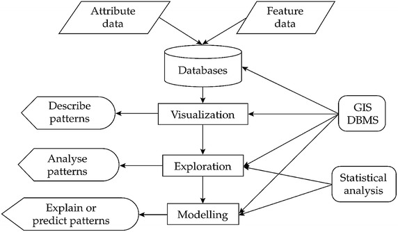
There is a great concern on how to build up an interoperable health information system of public health and health information technology within the development of public information and health surveillance programme. Technically, some major issues remain regarding to health data visualization, spatial processing of health data, health information dissemination, data sharing and the access of local communities to health information. In combination with GIS, we propose a technical framework for web-based health data visualization and spatial analysis.

METHODS

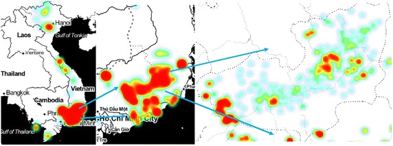
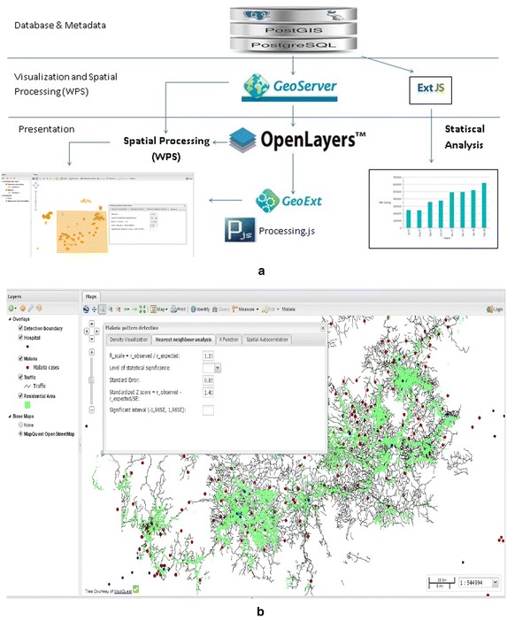
Data was collected from open map-servers and geocoded by open data kit package and data geocoding tools. The Web-based system is designed based on Open-source frameworks and libraries. The system provides Web-based analyst tool for pattern detection through three spatial tests: Nearest neighbour, K function, and Spatial Autocorrelation.

RESULTS

The result is a web-based GIS, through which end users can detect disease patterns via selecting area, spatial test parameters and contribute to managers and decision makers. The end users can be health practitioners, educators, local communities, health sector authorities and decision makers. This web-based system allows for the improvement of health related services to public sector users as well as citizens in a secure manner.

CONCLUSIONS

The combination of spatial statistics and web-based GIS can be a solution that helps empower health practitioners in direct and specific intersectional actions, thus provide for better analysis, control and decision-making.

摘要

引言

在公共信息和健康监测计划的发展过程中,如何构建一个公共卫生与健康信息技术可互操作的健康信息系统备受关注。从技术层面来看,在健康数据可视化、健康数据的空间处理、健康信息传播、数据共享以及当地社区获取健康信息等方面仍存在一些重大问题。结合地理信息系统(GIS),我们提出了一个基于网络的健康数据可视化和空间分析的技术框架。

方法

数据从开放地图服务器收集,并通过开放数据工具包和数据地理编码工具进行地理编码。基于网络的系统是基于开源框架和库设计的。该系统通过最近邻、K函数和空间自相关这三种空间测试,提供基于网络的模式检测分析工具。

结果

结果是一个基于网络的地理信息系统,终端用户可以通过选择区域、空间测试参数来检测疾病模式,并为管理人员和决策者提供信息。终端用户可以是医疗从业者、教育工作者、当地社区、卫生部门当局和决策者。这个基于网络的系统能够以安全的方式改善面向公共部门用户以及公民的健康相关服务。

结论

空间统计与基于网络的地理信息系统相结合,可以成为一种解决方案,有助于使医疗从业者在直接和特定的交叉行动中更有能力,从而实现更好的分析、控制和决策。

https://cdn.ncbi.nlm.nih.gov/pmc/blobs/9c5f/4938832/88527e5ee1f8/40064_2016_2518_Fig4_HTML.jpg
https://cdn.ncbi.nlm.nih.gov/pmc/blobs/9c5f/4938832/422c4f72a98f/40064_2016_2518_Fig1_HTML.jpg
https://cdn.ncbi.nlm.nih.gov/pmc/blobs/9c5f/4938832/98ed3e6822e5/40064_2016_2518_Fig2_HTML.jpg
https://cdn.ncbi.nlm.nih.gov/pmc/blobs/9c5f/4938832/b8e758ef2b5e/40064_2016_2518_Fig3_HTML.jpg
https://cdn.ncbi.nlm.nih.gov/pmc/blobs/9c5f/4938832/88527e5ee1f8/40064_2016_2518_Fig4_HTML.jpg

相似文献

1
Web-based GIS for spatial pattern detection: application to malaria incidence in Vietnam.用于空间模式检测的基于网络的地理信息系统:在越南疟疾发病率中的应用。
Springerplus. 2016 Jul 8;5(1):1014. doi: 10.1186/s40064-016-2518-5. eCollection 2016.
2
Using participatory design to develop (public) health decision support systems through GIS.利用参与式设计通过地理信息系统开发(公共)卫生决策支持系统。
Int J Health Geogr. 2007 Nov 27;6:53. doi: 10.1186/1476-072X-6-53.
3
Development of spatial density maps based on geoprocessing web services: application to tuberculosis incidence in Barcelona, Spain.基于地理处理 Web 服务的空间密度图的开发:在西班牙巴塞罗那结核病发病率中的应用。
Int J Health Geogr. 2011 Nov 29;10:62. doi: 10.1186/1476-072X-10-62.
4
Towards Web-based representation and processing of health information.迈向基于网络的健康信息表示与处理
Int J Health Geogr. 2009 Jan 21;8:3. doi: 10.1186/1476-072X-8-3.
5
Web platform using digital image processing and geographic information system tools: a Brazilian case study on dengue.使用数字图像处理和地理信息系统工具的网络平台:巴西登革热案例研究
Biomed Eng Online. 2015 Jul 16;14:69. doi: 10.1186/s12938-015-0052-2.
6
Web GIS in practice IV: publishing your health maps and connecting to remote WMS sources using the Open Source UMN MapServer and DM Solutions MapLab.Web GIS实践IV:使用开源UMN MapServer和DM Solutions MapLab发布健康地图并连接到远程WMS源。
Int J Health Geogr. 2006 Jan 18;5:6. doi: 10.1186/1476-072X-5-6.
7
Open source GIS for HIV/AIDS management.用于艾滋病毒/艾滋病管理的开源地理信息系统
Int J Health Geogr. 2008 Oct 22;7:53. doi: 10.1186/1476-072X-7-53.
8
Geographic information systems: introduction.地理信息系统:简介
Vet Ital. 2007 Jul-Sep;43(3):379.
9
Public health, GIS, and the internet.公共卫生、地理信息系统与互联网。
Annu Rev Public Health. 2003;24:57-82. doi: 10.1146/annurev.publhealth.24.012902.140835. Epub 2002 Oct 23.
10
Development of SOVAT: a numerical-spatial decision support system for community health assessment research.SOVAT的开发:一种用于社区健康评估研究的数值空间决策支持系统。
Int J Med Inform. 2006 Oct-Nov;75(10-11):771-84. doi: 10.1016/j.ijmedinf.2005.10.008. Epub 2005 Dec 15.

引用本文的文献

1
Malaria Trigram: improving the visualization of recurrence data for malaria elimination.疟疾三因图:改进疟疾消除中复发数据的可视化效果。
Malar J. 2021 Oct 30;20(1):431. doi: 10.1186/s12936-021-03964-z.
2
Artificial Intelligence vs. Natural Stupidity: Evaluating AI readiness for the Vietnamese Medical Information System.人工智能与天然愚笨:评估越南医疗信息系统的人工智能就绪情况。
J Clin Med. 2019 Feb 1;8(2):168. doi: 10.3390/jcm8020168.
3
A systematic review of spatial decision support systems in public health informatics supporting the identification of high risk areas for zoonotic disease outbreaks.

本文引用的文献

1
The geography of post-disaster mental health: spatial patterning of psychological vulnerability and resilience factors in New York City after Hurricane Sandy.灾后心理健康的地理分布:桑迪飓风过后纽约市心理脆弱性和恢复力因素的空间格局
Int J Health Geogr. 2015 Jun 10;14:16. doi: 10.1186/s12942-015-0008-6.
2
Why does geoprivacy matter? The scientific publication of confidential data presented on maps.地理隐私为何重要?地图上呈现的机密数据的科学出版物。
J Empir Res Hum Res Ethics. 2014 Oct;9(4):34-45. doi: 10.1177/1556264614544103. Epub 2014 Aug 11.
3
Spatial-explicit modeling of social vulnerability to malaria in East Africa.
系统评价公共卫生信息学中的空间决策支持系统,以支持识别动物源性疾病爆发的高风险区域。
Int J Health Geogr. 2018 Oct 30;17(1):38. doi: 10.1186/s12942-018-0157-5.
东非地区疟疾社会脆弱性的空间明确建模。
Int J Health Geogr. 2014 Aug 15;13:29. doi: 10.1186/1476-072X-13-29.
4
Visualization and analytics tools for infectious disease epidemiology: a systematic review.传染病流行病学的可视化与分析工具:一项系统综述
J Biomed Inform. 2014 Oct;51:287-98. doi: 10.1016/j.jbi.2014.04.006. Epub 2014 Apr 16.
5
Providing open access data online to advance malaria research and control.在线提供开放获取数据,以促进疟疾研究和控制。
Malar J. 2013 May 16;12:161. doi: 10.1186/1475-2875-12-161.
6
A review of spatial methods in epidemiology, 2000-2010.2000-2010 年流行病学空间方法研究述评。
Annu Rev Public Health. 2012 Apr;33:107-22. doi: 10.1146/annurev-publhealth-031811-124655.
7
Interactive web-based mapping: bridging technology and data for health.交互式网络地图绘制:连接技术与健康数据
Int J Health Geogr. 2011 Dec 23;10:69. doi: 10.1186/1476-072X-10-69.
8
Crowdsourcing, citizen sensing and sensor web technologies for public and environmental health surveillance and crisis management: trends, OGC standards and application examples.众包、公民感知和传感器网络技术在公共和环境健康监测及危机管理中的应用:趋势、OGC 标准和应用实例。
Int J Health Geogr. 2011 Dec 21;10:67. doi: 10.1186/1476-072X-10-67.
9
Development of spatial density maps based on geoprocessing web services: application to tuberculosis incidence in Barcelona, Spain.基于地理处理 Web 服务的空间密度图的开发:在西班牙巴塞罗那结核病发病率中的应用。
Int J Health Geogr. 2011 Nov 29;10:62. doi: 10.1186/1476-072X-10-62.
10
Epidemiologic research and Web 2.0--the user-driven Web.流行病学研究与Web 2.0——用户驱动的网络
Epidemiology. 2010 Nov;21(6):760-3. doi: 10.1097/EDE.0b013e3181f5a75f.