Singh Himalaya, Fortington Lauren V, Thompson Helen, Finch Caroline F
Australian Collaboration for Research into Injury in Sport and its Prevention (ACRISP), Federation University Australia, SMB Campus, PO Box 663, Ballarat, 3353, Australia.
School of Health Sciences and Psychology, Faculty of Health, Federation University Australia, Ballarat, Australia.
Inj Epidemiol. 2016 Dec;3(1):32. doi: 10.1186/s40621-016-0097-0. Epub 2016 Dec 26.
Injuries are a leading cause of death and disability around the world. Injury incidence is often associated with socio-economic and physical environmental factors. The application of geospatial methods has been recognised as important to gain greater understanding of the complex nature of injury and the associated diverse range of geographically-diverse risk factors. Therefore, the aim of this paper is to provide an overview of geospatial methods applied in unintentional injury epidemiological studies.
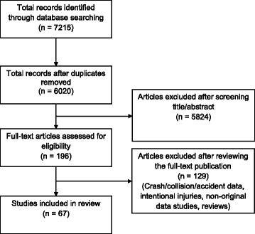
Nine electronic databases were searched for papers published in 2000-2015, inclusive. Included were papers reporting unintentional injuries using geospatial methods for one or more categories of spatial epidemiological methods (mapping; clustering/cluster detection; and ecological analysis). Results describe the included injury cause categories, types of data and details relating to the applied geospatial methods.
From over 6,000 articles, 67 studies met all inclusion criteria. The major categories of injury data reported with geospatial methods were road traffic (n = 36), falls (n = 11), burns (n = 9), drowning (n = 4), and others (n = 7). Grouped by categories, mapping was the most frequently used method, with 62 (93%) studies applying this approach independently or in conjunction with other geospatial methods. Clustering/cluster detection methods were less common, applied in 27 (40%) studies. Three studies (4%) applied spatial regression methods (one study using a conditional autoregressive model and two studies using geographically weighted regression) to examine the relationship between injury incidence (drowning, road deaths) with aggregated data in relation to explanatory factors (socio-economic and environmental).
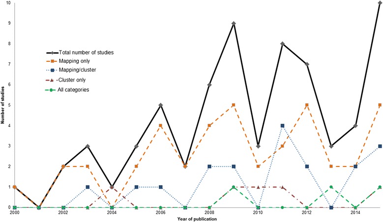
The number of studies using geospatial methods to investigate unintentional injuries has increased over recent years. While the majority of studies have focused on road traffic injuries, other injury cause categories, particularly falls and burns, have also demonstrated the application of these methods. Geospatial investigations of injury have largely been limited to mapping of data to visualise spatial structures. Use of more sophisticated approaches will help to understand a broader range of spatial risk factors, which remain under-explored when using traditional epidemiological approaches.
伤害是全球范围内死亡和残疾的主要原因。伤害发生率通常与社会经济和自然环境因素相关。地理空间方法的应用被认为对于更深入理解伤害的复杂本质以及相关的各种地理上不同的风险因素非常重要。因此,本文旨在概述应用于非故意伤害流行病学研究的地理空间方法。
检索了9个电子数据库,查找2000年至2015年(含)发表的论文。纳入的论文需报告使用地理空间方法对一类或多类空间流行病学方法(绘图;聚类/聚类检测;以及生态分析)进行的非故意伤害情况。结果描述了纳入的伤害原因类别、数据类型以及与应用的地理空间方法相关的详细信息。
从6000多篇文章中,有67项研究符合所有纳入标准。使用地理空间方法报告的主要伤害数据类别包括道路交通(n = 36)、跌倒(n = 11)、烧伤(n = 9)、溺水(n = 4)以及其他(n = 7)。按类别分组,绘图是最常用的方法,有62项(93%)研究单独应用此方法或与其他地理空间方法结合使用。聚类/聚类检测方法不太常见,在27项(40%)研究中应用。三项研究(4%)应用空间回归方法(一项研究使用条件自回归模型,两项研究使用地理加权回归)来检验伤害发生率(溺水、道路死亡)与汇总数据中解释因素(社会经济和环境)之间的关系。
近年来,使用地理空间方法调查非故意伤害的研究数量有所增加。虽然大多数研究集中在道路交通伤害方面,但其他伤害原因类别,特别是跌倒和烧伤,也展示了这些方法的应用。伤害的地理空间调查在很大程度上仅限于数据绘图以可视化空间结构。使用更复杂的方法将有助于理解更广泛的空间风险因素,而这些因素在使用传统流行病学方法时仍未得到充分探索。