• 文献检索
  • 文档翻译
  • 深度研究
  • 学术资讯
  • Suppr Zotero 插件Zotero 插件
  • 邀请有礼
  • 套餐&价格
  • 历史记录
应用&插件
Suppr Zotero 插件Zotero 插件浏览器插件Mac 客户端Windows 客户端微信小程序
定价
高级版会员购买积分包购买API积分包
服务
文献检索文档翻译深度研究API 文档MCP 服务
关于我们
关于 Suppr公司介绍联系我们用户协议隐私条款
关注我们

Suppr 超能文献

核心技术专利:CN118964589B侵权必究
粤ICP备2023148730 号-1Suppr @ 2026

文献检索

告别复杂PubMed语法,用中文像聊天一样搜索,搜遍4000万医学文献。AI智能推荐,让科研检索更轻松。

立即免费搜索

文件翻译

保留排版,准确专业,支持PDF/Word/PPT等文件格式,支持 12+语言互译。

免费翻译文档

深度研究

AI帮你快速写综述,25分钟生成高质量综述,智能提取关键信息,辅助科研写作。

立即免费体验

车辆相对定位的测距传感器与协作技术调查

Survey on Ranging Sensors and Cooperative Techniques for Relative Positioning of Vehicles.

作者信息

de Ponte Müller Fabian

机构信息

German Aerospace Center (DLR), Institute of Communications and Navigation, 82234Wessling, Germany.

出版信息

Sensors (Basel). 2017 Jan 31;17(2):271. doi: 10.3390/s17020271.

DOI:10.3390/s17020271
PMID:28146129
原文链接:https://pmc.ncbi.nlm.nih.gov/articles/PMC5335929/
Abstract

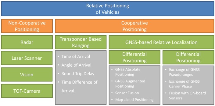
Future driver assistance systems will rely on accurate, reliable and continuous knowledge on the position of other road participants, including pedestrians, bicycles and other vehicles. The usual approach to tackle this requirement is to use on-board ranging sensors inside the vehicle. Radar, laser scanners or vision-based systems are able to detect objects in their line-of-sight. In contrast to these non-cooperative ranging sensors, cooperative approaches follow a strategy in which other road participants actively support the estimation of the relative position. The limitations of on-board ranging sensors regarding their detection range and angle of view and the facility of blockage can be approached by using a cooperative approach based on vehicle-to-vehicle communication. The fusion of both, cooperative and non-cooperative strategies, seems to offer the largest benefits regarding accuracy, availability and robustness. This survey offers the reader a comprehensive review on different techniques for vehicle relative positioning. The reader will learn the important performance indicators when it comes to relative positioning of vehicles, the different technologies that are both commercially available and currently under research, their expected performance and their intrinsic limitations. Moreover, the latest research in the area of vision-based systems for vehicle detection, as well as the latest work on GNSS-based vehicle localization and vehicular communication for relative positioning of vehicles, are reviewed. The survey also includes the research work on the fusion of cooperative and non-cooperative approaches to increase the reliability and the availability.

摘要

未来的驾驶辅助系统将依赖于对其他道路参与者位置的准确、可靠且持续的了解,这些参与者包括行人、自行车和其他车辆。满足这一需求的常用方法是在车辆内部使用车载测距传感器。雷达、激光扫描仪或基于视觉的系统能够检测其视线范围内的物体。与这些非合作测距传感器不同,合作方法遵循一种策略,即其他道路参与者积极支持相对位置的估计。通过使用基于车对车通信的合作方法,可以解决车载测距传感器在检测范围、视角和遮挡方面的局限性。合作策略与非合作策略的融合,在准确性、可用性和鲁棒性方面似乎能带来最大的益处。本综述为读者提供了关于车辆相对定位不同技术的全面回顾。读者将了解车辆相对定位时的重要性能指标、市面上已有的以及目前正在研究的不同技术、它们预期的性能以及固有的局限性。此外,还综述了基于视觉的车辆检测系统领域的最新研究,以及基于全球导航卫星系统(GNSS)的车辆定位和用于车辆相对定位的车辆通信方面的最新工作。本综述还包括关于融合合作与非合作方法以提高可靠性和可用性的研究工作。

https://cdn.ncbi.nlm.nih.gov/pmc/blobs/2d35/5335929/09efea4fa7bd/sensors-17-00271-g005.jpg
https://cdn.ncbi.nlm.nih.gov/pmc/blobs/2d35/5335929/3fe94bc745f1/sensors-17-00271-g001.jpg
https://cdn.ncbi.nlm.nih.gov/pmc/blobs/2d35/5335929/2198c015b4f4/sensors-17-00271-g002.jpg
https://cdn.ncbi.nlm.nih.gov/pmc/blobs/2d35/5335929/9ce90c22b594/sensors-17-00271-g003.jpg
https://cdn.ncbi.nlm.nih.gov/pmc/blobs/2d35/5335929/e99c68db17bd/sensors-17-00271-g004.jpg
https://cdn.ncbi.nlm.nih.gov/pmc/blobs/2d35/5335929/09efea4fa7bd/sensors-17-00271-g005.jpg

相似文献

1
Survey on Ranging Sensors and Cooperative Techniques for Relative Positioning of Vehicles.车辆相对定位的测距传感器与协作技术调查
Sensors (Basel). 2017 Jan 31;17(2):271. doi: 10.3390/s17020271.
2
An Empirical Study on V2X Enhanced Low-Cost GNSS Cooperative Positioning in Urban Environments.车联网增强的低成本 GNSS 协作定位在城市环境中的实证研究。
Sensors (Basel). 2019 Nov 27;19(23):5201. doi: 10.3390/s19235201.
3
Robust Cooperative Multi-Vehicle Tracking with Inaccurate Self-Localization Based on On-Board Sensors and Inter-Vehicle Communication.基于车载传感器和车际通信的具有不准确自身定位的稳健协作多车辆跟踪
Sensors (Basel). 2020 Jun 5;20(11):3212. doi: 10.3390/s20113212.
4
An Integrated Dead Reckoning with Cooperative Positioning Solution to Assist GPS NLOS Using Vehicular Communications.利用车载通信辅助 GPS 非视距的集成航位推算与协作定位解决方案。
Sensors (Basel). 2018 Aug 31;18(9):2895. doi: 10.3390/s18092895.
5
A Timing Estimation Method Based-on Skewness Analysis in Vehicular Wireless Networks.一种基于车辆无线网络中偏度分析的定时估计方法。
Sensors (Basel). 2015 Nov 13;15(11):28942-59. doi: 10.3390/s151128942.
6
A Distributed Cooperative Localization Strategy in Vehicular-to-Vehicular Networks.车对车网络中的分布式协作定位策略
Sensors (Basel). 2020 Mar 4;20(5):1413. doi: 10.3390/s20051413.
7
A Unified Multiple-Target Positioning Framework for Intelligent Connected Vehicles.一种用于智能网联汽车的统一多目标定位框架。
Sensors (Basel). 2019 Apr 26;19(9):1967. doi: 10.3390/s19091967.
8
Vision-Based Steering Control, Speed Assistance and Localization for Inner-City Vehicles.基于视觉的城市车辆转向控制、速度辅助与定位
Sensors (Basel). 2016 Mar 11;16(3):362. doi: 10.3390/s16030362.
9
Spatiotemporal Local-Remote Senor Fusion (ST-LRSF) for Cooperative Vehicle Positioning.用于协作车辆定位的时空局部-远程传感器融合(ST-LRSF)
Sensors (Basel). 2018 Apr 4;18(4):1092. doi: 10.3390/s18041092.
10
Vehicle Trajectory Prediction and Collision Warning via Fusion of Multisensors and Wireless Vehicular Communications.基于多传感器融合和车联网的车辆轨迹预测与碰撞预警
Sensors (Basel). 2020 Jan 4;20(1):288. doi: 10.3390/s20010288.

引用本文的文献

1
Realistic 3D Simulators for Automotive: A Review of Main Applications and Features.汽车领域的逼真3D模拟器:主要应用与特性综述
Sensors (Basel). 2024 Sep 10;24(18):5880. doi: 10.3390/s24185880.
2
Improved DeepSORT-Based Object Tracking in Foggy Weather for AVs Using Sematic Labels and Fused Appearance Feature Network.基于改进深度排序的自动驾驶车辆在雾天中使用语义标签和融合外观特征网络的目标跟踪
Sensors (Basel). 2024 Jul 19;24(14):4692. doi: 10.3390/s24144692.
3
Advances in Real-Time 3D Reconstruction for Medical Endoscopy.医学内窥镜实时三维重建的进展

本文引用的文献

1
Vertical Corner Feature Based Precise Vehicle Localization Using 3D LIDAR in Urban Area.基于垂直角特征的城市区域3D激光雷达精确车辆定位
Sensors (Basel). 2016 Aug 10;16(8):1268. doi: 10.3390/s16081268.
2
Vision-Based Steering Control, Speed Assistance and Localization for Inner-City Vehicles.基于视觉的城市车辆转向控制、速度辅助与定位
Sensors (Basel). 2016 Mar 11;16(3):362. doi: 10.3390/s16030362.
3
Definition of an Enhanced Map-Matching Algorithm for Urban Environments with Poor GNSS Signal Quality.针对全球导航卫星系统(GNSS)信号质量较差的城市环境的增强型地图匹配算法的定义。
J Imaging. 2024 May 14;10(5):120. doi: 10.3390/jimaging10050120.
4
Recent Advances in mmWave-Radar-Based Sensing, Its Applications, and Machine Learning Techniques: A Review.基于毫米波雷达的传感、其应用及机器学习技术的最新进展:综述
Sensors (Basel). 2023 Nov 1;23(21):8901. doi: 10.3390/s23218901.
5
INS/LIDAR/Stereo SLAM Integration for Precision Navigation in GNSS-Denied Environments.用于全球导航卫星系统(GNSS)信号受限环境下精确导航的惯性导航系统(INS)/激光雷达/立体同步定位与地图构建(Stereo SLAM)集成
Sensors (Basel). 2023 Aug 25;23(17):7424. doi: 10.3390/s23177424.
6
Deep Camera-Radar Fusion with an Attention Framework for Autonomous Vehicle Vision in Foggy Weather Conditions.用于雾天条件下自动驾驶车辆视觉的具有注意力框架的深度相机-雷达融合
Sensors (Basel). 2023 Jul 9;23(14):6255. doi: 10.3390/s23146255.
7
Deep Learning-Aided Inertial/Visual/LiDAR Integration for GNSS-Challenging Environments.深度学习辅助的惯性/视觉/激光雷达融合在 GNSS 挑战性环境下的应用。
Sensors (Basel). 2023 Jun 29;23(13):6019. doi: 10.3390/s23136019.
8
Bio-Inspired Autonomous Navigation and Formation Controller for Differential Mobile Robots.用于差分移动机器人的生物启发式自主导航与编队控制器
Entropy (Basel). 2023 Mar 28;25(4):582. doi: 10.3390/e25040582.
9
A Novel Transformer-Based IMU Self-Calibration Approach through On-Board RGB Camera for UAV Flight Stabilization.基于新型 Transformer 的 IMU 自标定方法,通过机载 RGB 相机实现无人机飞行稳定。
Sensors (Basel). 2023 Feb 28;23(5):2655. doi: 10.3390/s23052655.
10
An Integrated INS/LiDAR SLAM Navigation System for GNSS-Challenging Environments.一种适用于全球导航卫星系统(GNSS)受限环境的集成惯性导航系统/激光雷达同步定位与地图构建(INS/LiDAR SLAM)导航系统。
Sensors (Basel). 2022 Jun 7;22(12):4327. doi: 10.3390/s22124327.
Sensors (Basel). 2016 Feb 4;16(2):193. doi: 10.3390/s16020193.
4
Localization and mapping using only a rotating FMCW radar sensor.仅使用旋转调频连续波雷达传感器进行定位和映射。
Sensors (Basel). 2013 Apr 8;13(4):4527-52. doi: 10.3390/s130404527.
5
On-road vehicle detection: a review.道路车辆检测:综述
IEEE Trans Pattern Anal Mach Intell. 2006 May;28(5):694-711. doi: 10.1109/TPAMI.2006.104.