Brenner Claire, Thiem Christina Elisabeth, Wizemann Hans-Dieter, Bernhardt Matthias, Schulz Karsten
Institute of Water Management, Hydrology and Hydraulic Engineering, University of Natural Resources and Life Sciences, Vienna, Austria.
Institute of Physics and Meteorology, University of Hohenheim, Stuttgart, Germany.
Int J Remote Sens. 2017 May 19;38(8-10):3003-3026. doi: 10.1080/01431161.2017.1280202. Epub 2017 Jan 31.
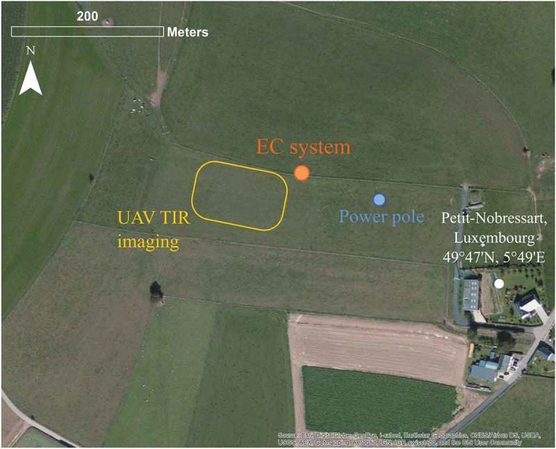
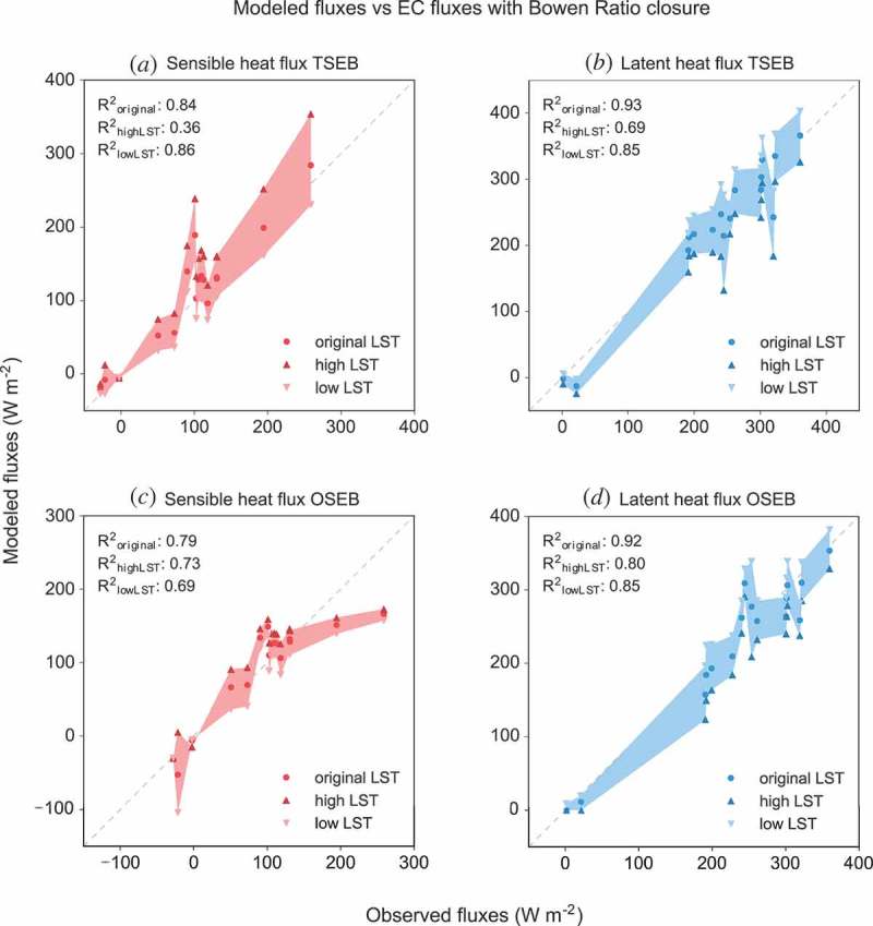
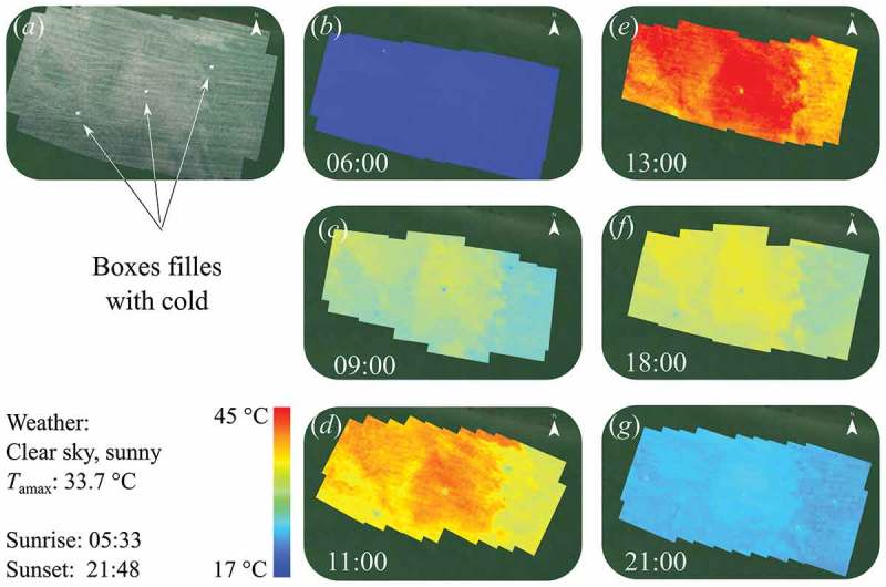
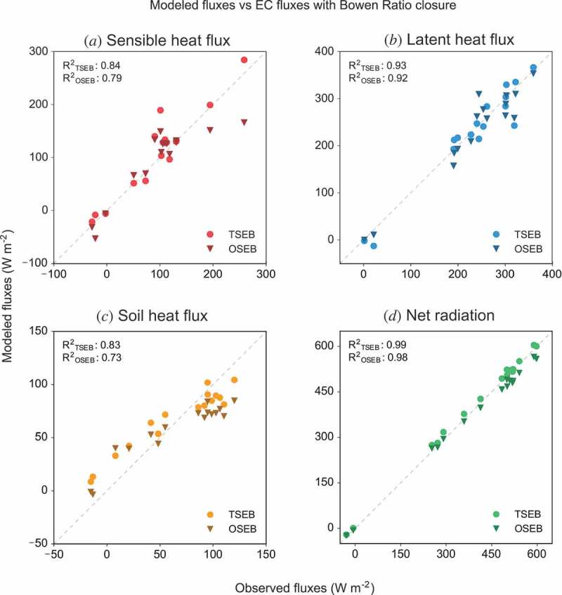
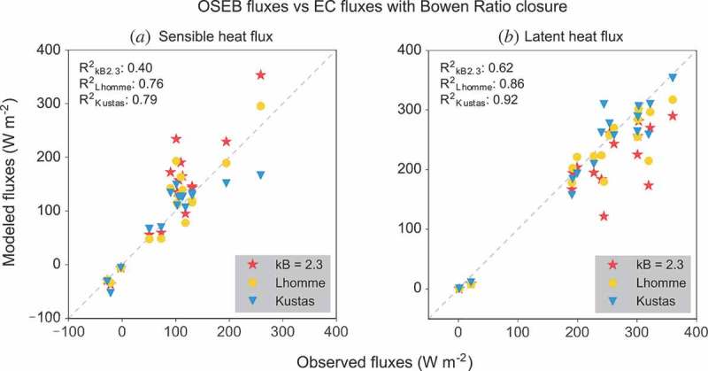
In this study, high-resolution thermal imagery acquired with a small unmanned aerial vehicle (UAV) is used to map evapotranspiration (ET) at a grassland site in Luxembourg. The land surface temperature (LST) information from the thermal imagery is the key input to a one-source and two-source energy balance model. While the one-source model treats the surface as a single uniform layer, the two-source model partitions the surface temperature and fluxes into soil and vegetation components. It thus explicitly accounts for the different contributions of both components to surface temperature as well as turbulent flux exchange with the atmosphere. Contrary to the two-source model, the one-source model requires an empirical adjustment parameter in order to account for the effect of the two components. Turbulent heat flux estimates of both modelling approaches are compared to eddy covariance (EC) measurements using the high-resolution input imagery UAVs provide. In this comparison, the effect of different methods for energy balance closure of the EC data on the agreement between modelled and measured fluxes is also analysed. Additionally, the sensitivity of the one-source model to the derivation of the empirical adjustment parameter is tested. Due to the very dry and hot conditions during the experiment, pronounced thermal patterns developed over the grassland site. These patterns result in spatially variable turbulent heat fluxes. The model comparison indicates that both models are able to derive ET estimates that compare well with EC measurements under these conditions. However, the two-source model, with a more complex treatment of the energy and surface temperature partitioning between the soil and vegetation, outperformed the simpler one-source model in estimating sensible and latent heat fluxes. This is consistent with findings from prior studies. For the one-source model, a time-variant expression of the adjustment parameter (to account for the difference between aerodynamic and radiometric temperature) that depends on the surface-to-air temperature gradient yielded the best agreement with EC measurements. This study showed that the applied UAV system equipped with a dual-camera set-up allows for the acquisition of thermal imagery with high spatial and temporal resolution that illustrates the small-scale heterogeneity of thermal surface properties. The UAV-based thermal imagery therefore provides the means for analysing patterns of LST and other surface properties with a high level of detail that cannot be obtained by traditional remote sensing methods.
在本研究中,利用小型无人机(UAV)获取的高分辨率热成像来绘制卢森堡某草地站点的蒸散量(ET)。热成像中的地表温度(LST)信息是单源和双源能量平衡模型的关键输入。单源模型将地表视为单一均匀层,而双源模型则将地表温度和通量划分为土壤和植被成分。因此,它明确考虑了这两个成分对地表温度的不同贡献以及与大气的湍流通量交换。与双源模型不同,单源模型需要一个经验调整参数来考虑这两个成分的影响。使用无人机提供的高分辨率输入图像,将两种建模方法的湍流通量估计值与涡度协方差(EC)测量值进行比较。在该比较中,还分析了EC数据的不同能量平衡闭合方法对建模通量与实测通量之间一致性的影响。此外,还测试了单源模型对经验调整参数推导的敏感性。由于实验期间天气非常干燥炎热,草地站点出现了明显的热模式。这些模式导致湍流通量在空间上变化。模型比较表明,在这些条件下,两种模型都能够得出与EC测量值比较相符的ET估计值。然而,双源模型对土壤和植被之间的能量及地表温度划分进行了更复杂的处理,在估计感热通量和潜热通量方面优于更简单的单源模型。这与先前研究的结果一致。对于单源模型,一个取决于地表与气温梯度的调整参数的时变表达式(用于考虑空气动力学温度与辐射温度之间的差异)与EC测量值的一致性最佳。本研究表明,所应用的配备双相机设置的无人机系统能够获取具有高空间和时间分辨率的热成像,从而展示热表面特性的小尺度异质性。因此,基于无人机的热成像提供了一种手段,能够以传统遥感方法无法实现的高细节水平分析LST和其他表面特性的模式。