• 文献检索
  • 文档翻译
  • 深度研究
  • 学术资讯
  • Suppr Zotero 插件Zotero 插件
  • 邀请有礼
  • 套餐&价格
  • 历史记录
应用&插件
Suppr Zotero 插件Zotero 插件浏览器插件Mac 客户端Windows 客户端微信小程序
定价
高级版会员购买积分包购买API积分包
服务
文献检索文档翻译深度研究API 文档MCP 服务
关于我们
关于 Suppr公司介绍联系我们用户协议隐私条款
关注我们

Suppr 超能文献

核心技术专利:CN118964589B侵权必究
粤ICP备2023148730 号-1Suppr @ 2026

文献检索

告别复杂PubMed语法,用中文像聊天一样搜索,搜遍4000万医学文献。AI智能推荐,让科研检索更轻松。

立即免费搜索

文件翻译

保留排版,准确专业,支持PDF/Word/PPT等文件格式,支持 12+语言互译。

免费翻译文档

深度研究

AI帮你快速写综述,25分钟生成高质量综述,智能提取关键信息,辅助科研写作。

立即免费体验

精准农业中小型无人机蒸散量估算。

Evapotranspiration Estimation with Small UAVs in Precision Agriculture.

机构信息

Electrical Engineering and Computer Science Department, University of California, Merced, CA 95340, USA.

Mechanical Engineering Department, University of California, Merced, CA 95340, USA.

出版信息

Sensors (Basel). 2020 Nov 10;20(22):6427. doi: 10.3390/s20226427.

DOI:10.3390/s20226427
PMID:33182824
原文链接:https://pmc.ncbi.nlm.nih.gov/articles/PMC7697511/
Abstract

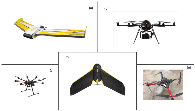
Estimating evapotranspiration (ET) has been one of the most critical research areas in agriculture because of water scarcity, the growing population, and climate change. The accurate estimation and mapping of ET are necessary for crop water management. Traditionally, researchers use water balance, soil moisture, weighing lysimeters, or an energy balance approach, such as Bowen ratio or eddy covariance towers to estimate ET. However, these ET methods are point-specific or area-weighted measurements and cannot be extended to a large scale. With the advent of satellite technology, remote sensing images became able to provide spatially distributed measurements. However, the spatial resolution of multispectral satellite images is in the range of meters, tens of meters, or hundreds of meters, which is often not enough for crops with clumped canopy structures, such as trees and vines. Unmanned aerial vehicles (UAVs) can mitigate these spatial and temporal limitations. Lightweight cameras and sensors can be mounted on the UAVs and take high-resolution images. Unlike satellite imagery, the spatial resolution of the UAV images can be at the centimeter-level. UAVs can also fly on-demand, which provides high temporal imagery. In this study, the authors examined different UAV-based approaches of ET estimation at first. Models and algorithms, such as mapping evapotranspiration at high resolution with internalized calibration (METRIC), the two-source energy balance (TSEB) model, and machine learning (ML) are analyzed and discussed herein. Second, challenges and opportunities for UAVs in ET estimation are also discussed, such as uncooled thermal camera calibration, UAV image collection, and image processing. Then, the authors share views on ET estimation with UAVs for future research and draw conclusive remarks.

摘要

估算蒸散量(ET)一直是农业领域最关键的研究领域之一,因为水资源短缺、人口增长和气候变化。准确估算和绘制 ET 是作物水分管理所必需的。传统上,研究人员使用水量平衡、土壤湿度、称重蒸渗仪或能量平衡方法,如波文比或涡度协方差塔来估算 ET。然而,这些 ET 方法是点特定或区域加权测量,无法扩展到大规模。随着卫星技术的出现,遥感图像能够提供空间分布的测量。然而,多光谱卫星图像的空间分辨率在米、数十米或数百米范围内,对于树冠结构密集的作物(如树木和葡萄藤)来说通常不够。无人机 (UAV) 可以减轻这些时空限制。轻型摄像机和传感器可以安装在 UAV 上,并拍摄高分辨率图像。与卫星图像不同,UAV 图像的空间分辨率可以达到厘米级。UAV 还可以按需飞行,提供高时间分辨率的图像。在这项研究中,作者首先检查了不同的基于 UAV 的 ET 估算方法。在此分析和讨论了模型和算法,例如使用内部校准(METRIC)以高分辨率映射蒸散量、两源能量平衡(TSEB)模型和机器学习(ML)。其次,还讨论了 UAV 在 ET 估算中的挑战和机遇,例如非冷却热像仪校准、UAV 图像采集和图像处理。然后,作者分享了对未来研究中使用 UAV 进行 ET 估算的看法,并得出结论性意见。

https://cdn.ncbi.nlm.nih.gov/pmc/blobs/667e/7697511/8be31d270090/sensors-20-06427-g001.jpg

相似文献

1
Evapotranspiration Estimation with Small UAVs in Precision Agriculture.精准农业中小型无人机蒸散量估算。
Sensors (Basel). 2020 Nov 10;20(22):6427. doi: 10.3390/s20226427.
2
Incorporation of Unmanned Aerial Vehicle (UAV) Point Cloud Products into Remote Sensing Evapotranspiration Models.将无人机(UAV)点云产品纳入遥感蒸散模型。
Remote Sens (Basel). 2020;12(1):50. doi: 10.3390/rs12010050.
3
Influence of Model Grid Size on the Estimation of Surface Fluxes Using the Two Source Energy Balance Model and sUAS Imagery in Vineyards.模型网格大小对葡萄园使用双源能量平衡模型和小型无人机影像估算地表通量的影响
Remote Sens (Basel). 2020;12(3):342. doi: 10.3390/rs12030342.
4
Estimation of evapotranspiration of temperate grassland based on high-resolution thermal and visible range imagery from unmanned aerial systems.基于无人机系统高分辨率热成像和可见光成像估算温带草原蒸散量
Int J Remote Sens. 2018 May 10;39(15-16):5141-5174. doi: 10.1080/01431161.2018.1471550. eCollection 2018.
5
Operational daily evapotranspiration mapping at field scale based on SSEBop model and spatiotemporal fusion of multi-source remote sensing data.基于 SSEBop 模型和多源遥感数据时空融合的田间尺度日蒸散量作业制图。
PLoS One. 2022 Feb 17;17(2):e0264133. doi: 10.1371/journal.pone.0264133. eCollection 2022.
6
Assessing Daily Evapotranspiration Methodologies from One-Time-of-Day sUAS and EC Information in the Project.在该项目中,根据单日小型无人机系统(sUAS)和涡度相关法(EC)信息评估日蒸散量方法。
Remote Sens (Basel). 2021 Aug 1;13(15):2887. doi: 10.3390/rs13152887. Epub 2021 Jul 23.
7
Evaluation of TSEB turbulent fluxes using different methods for the retrieval of soil and canopy component temperatures from UAV thermal and multispectral imagery.利用不同方法从无人机热成像和多光谱影像中反演土壤和冠层组分温度来评估TSEB湍流通量
Irrig Sci. 2019;37(3):389-406. doi: 10.1007/s00271-018-0585-9.
8
Nano and Micro Unmanned Aerial Vehicles (UAVs): A New Grand Challenge for Precision Agriculture?纳米和微型无人机:精准农业面临的新重大挑战?
Curr Protoc Plant Biol. 2020 Mar;5(1):e20103. doi: 10.1002/cppb.20103.
9
Unmanned Aerial Vehicles for High-Throughput Phenotyping and Agronomic Research.用于高通量表型分析和农艺学研究的无人机
PLoS One. 2016 Jul 29;11(7):e0159781. doi: 10.1371/journal.pone.0159781. eCollection 2016.
10
Perspectives for Remote Sensing with Unmanned Aerial Vehicles in Precision Agriculture.在精准农业中使用无人机进行遥感的展望。
Trends Plant Sci. 2019 Feb;24(2):152-164. doi: 10.1016/j.tplants.2018.11.007. Epub 2018 Dec 15.

引用本文的文献

1
Image-based vegetation analysis of desertified area by using a combination of ImageJ and Photoshop software.利用 ImageJ 和 Photoshop 软件组合进行荒漠化地区的基于图像的植被分析。
Environ Monit Assess. 2024 Feb 26;196(3):306. doi: 10.1007/s10661-024-12479-4.
2
Web and MATLAB-Based Platform for UAV Flight Management and Multispectral Image Processing.基于网络和 MATLAB 的无人机飞行管理和多光谱图像处理平台。
Sensors (Basel). 2022 Jun 2;22(11):4243. doi: 10.3390/s22114243.
3
Building a UAV Based System to Acquire High Spatial Resolution Thermal Imagery for Energy Balance Modelling.

本文引用的文献

1
Estimation of Evapotranspiration and Energy Fluxes using a Deep-Learning based High-Resolution Emissivity Model and the Two-Source Energy Balance Model with sUAS information.使用基于深度学习的高分辨率发射率模型和带有小型无人机系统(sUAS)信息的双源能量平衡模型估算蒸散量和能量通量。
Proc SPIE Int Soc Opt Eng. 2020 Jun 2;11414. doi: 10.1117/12.2558824. Epub 2020 May 14.
2
Thermal infrared imaging of crop canopies for the remote diagnosis and quantification of plant responses to water stress in the field.用于田间植物对水分胁迫响应的远程诊断和定量分析的作物冠层热红外成像
Funct Plant Biol. 2009 Nov;36(11):978-989. doi: 10.1071/FP09123.
3
基于无人机的系统构建,用于获取高空间分辨率热图像以进行能量平衡建模。
Sensors (Basel). 2022 Apr 23;22(9):3251. doi: 10.3390/s22093251.
4
Assessing Daily Evapotranspiration Methodologies from One-Time-of-Day sUAS and EC Information in the Project.在该项目中,根据单日小型无人机系统(sUAS)和涡度相关法(EC)信息评估日蒸散量方法。
Remote Sens (Basel). 2021 Aug 1;13(15):2887. doi: 10.3390/rs13152887. Epub 2021 Jul 23.
5
Why Do Big Data and Machine Learning Entail the Fractional Dynamics?为何大数据和机器学习需要分数动力学?
Entropy (Basel). 2021 Feb 28;23(3):297. doi: 10.3390/e23030297.
6
Influence of Model Grid Size on the Estimation of Surface Fluxes Using the Two Source Energy Balance Model and sUAS Imagery in Vineyards.模型网格大小对葡萄园使用双源能量平衡模型和小型无人机影像估算地表通量的影响
Remote Sens (Basel). 2020;12(3):342. doi: 10.3390/rs12030342.
Evaluation of TSEB turbulent fluxes using different methods for the retrieval of soil and canopy component temperatures from UAV thermal and multispectral imagery.
利用不同方法从无人机热成像和多光谱影像中反演土壤和冠层组分温度来评估TSEB湍流通量
Irrig Sci. 2019;37(3):389-406. doi: 10.1007/s00271-018-0585-9.
4
Artificial Neural Network to Predict Vine Water Status Spatial Variability Using Multispectral Information Obtained from an Unmanned Aerial Vehicle (UAV).利用无人机(UAV)获取的多光谱信息,通过人工神经网络预测葡萄藤水分状况的空间变异性。
Sensors (Basel). 2017 Oct 30;17(11):2488. doi: 10.3390/s17112488.
5
Uncooled Thermal Camera Calibration and Optimization of the Photogrammetry Process for UAV Applications in Agriculture.非制冷热成像相机校准及用于农业无人机应用的摄影测量过程优化
Sensors (Basel). 2017 Sep 23;17(10):2173. doi: 10.3390/s17102173.
6
Vicarious Calibration of sUAS Microbolometer Temperature Imagery for Estimation of Radiometric Land Surface Temperature.用于估算辐射陆地表面温度的小型无人机(sUAS)微测辐射热计温度图像的替代校准
Sensors (Basel). 2017 Jun 26;17(7):1499. doi: 10.3390/s17071499.
7
Estimating spatially distributed turbulent heat fluxes from high-resolution thermal imagery acquired with a UAV system.利用无人机系统获取的高分辨率热成像估算空间分布的湍流通量。
Int J Remote Sens. 2017 May 19;38(8-10):3003-3026. doi: 10.1080/01431161.2017.1280202. Epub 2017 Jan 31.
8
Assessment of Unmanned Aerial Vehicles Imagery for Quantitative Monitoring of Wheat Crop in Small Plots.用于小地块小麦作物定量监测的无人机图像评估
Sensors (Basel). 2008 May 26;8(5):3557-3585. doi: 10.3390/s8053557.
9
Assessment of Evapotranspiration and Soil Moisture Content Across Different Scales of Observation.不同观测尺度下蒸散量与土壤含水量的评估
Sensors (Basel). 2008 Jan 9;8(1):70-117. doi: 10.3390/s8010070.
10
Quantifying outdoor water consumption of urban land use/land cover: sensitivity to drought.量化城市土地利用/土地覆盖的室外用水量:对干旱的敏感性
Environ Manage. 2014 Apr;53(4):855-64. doi: 10.1007/s00267-014-0245-7. Epub 2014 Feb 5.