Li Qiaoxuan, Ren Hongyan, Zheng Lan, Cao Wei, Zhang An, Zhuang Dafang, Lu Liang, Jiang Huixian
College of Geographical Sciences, Fujian Normal University, No. 8 Shangsan Road, Fuzhou 350007, China.
State Key Laboratory of Resources and Environmental Information System, Institute of Geographic Sciences and Natural Resources Research, Chinese Academy of Sciences, 11A Datun Road, Chaoyang District, Beijing 100101, China.
Int J Environ Res Public Health. 2017 Jun 9;14(6):619. doi: 10.3390/ijerph14060619.
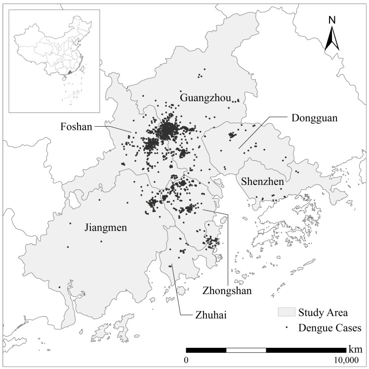
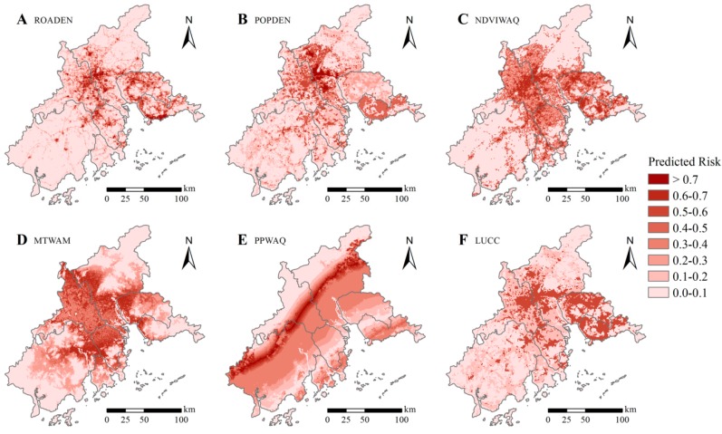
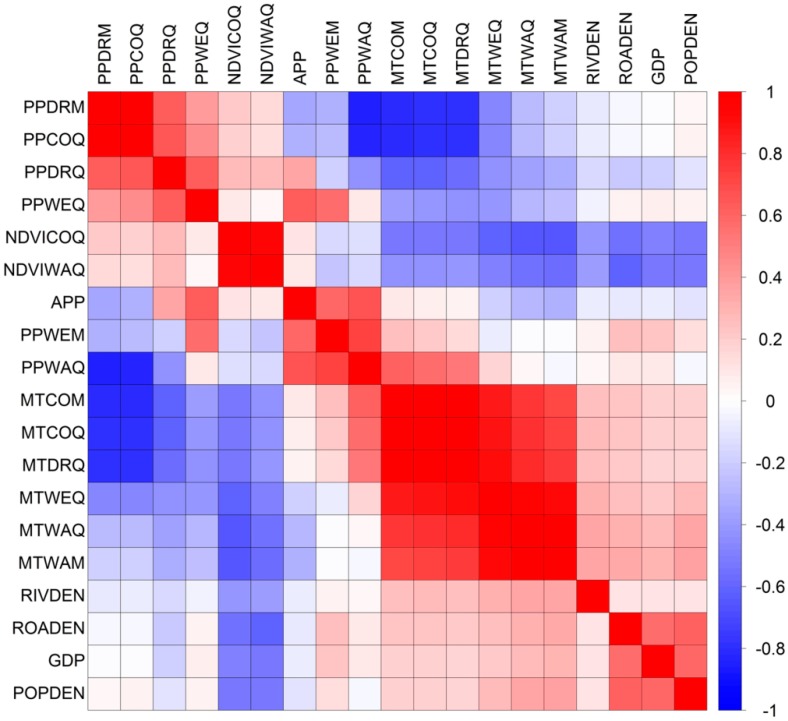
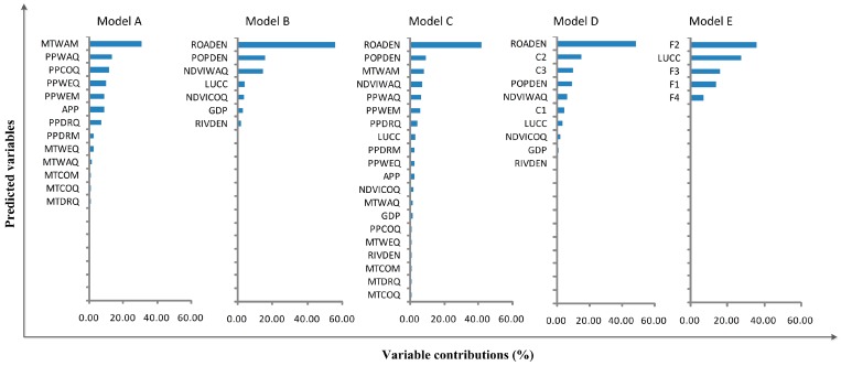
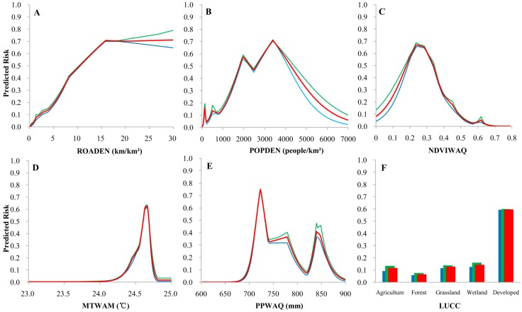
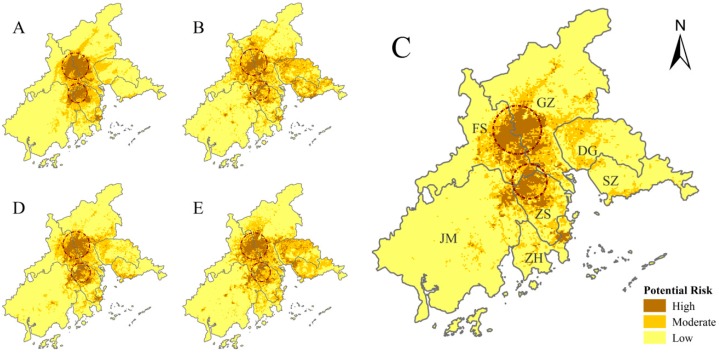
Dengue fever (DF) is one of the most common and rapidly spreading mosquito-borne viral diseases in tropical and subtropical regions. In recent years, this imported disease has posed a serious threat to public health in China, especially in the Pearl River Delta (PRD). Although the severity of DF outbreaks in the PRD is generally associated with known risk factors, fine scale assessments of areas at high risk for DF outbreaks are limited. We built five ecological niche models to identify such areas including a variety of climatic, environmental, and socioeconomic variables, as well as, in some models, extracted principal components. All the models we tested accurately identified the risk of DF, the area under the receiver operating characteristic curve (AUC) were greater than 0.8, but the model using all original variables was the most accurate (AUC = 0.906). Socioeconomic variables had a greater impact on this model (total contribution 55.27%) than climatic and environmental variables (total contribution 44.93%). We found the highest risk of DF outbreaks on the border of Guangzhou and Foshan (in the central PRD), and in northern Zhongshan (in the southern PRD). Our fine-scale results may help health agencies to focus epidemic monitoring tightly on the areas at highest risk of DF outbreaks.
登革热(DF)是热带和亚热带地区最常见且传播迅速的蚊媒病毒性疾病之一。近年来,这种输入性疾病对中国公共卫生,尤其是珠江三角洲(PRD)地区构成了严重威胁。尽管珠江三角洲登革热疫情的严重程度通常与已知风险因素相关,但对登革热疫情高风险地区的精细评估仍然有限。我们构建了五个生态位模型来识别这些地区,模型纳入了各种气候、环境和社会经济变量,并且在一些模型中提取了主成分。我们测试的所有模型都准确识别了登革热风险,受试者工作特征曲线下面积(AUC)均大于0.8,但使用所有原始变量的模型最为准确(AUC = 0.906)。社会经济变量对该模型的影响(总贡献率55.27%)大于气候和环境变量(总贡献率44.93%)。我们发现广州和佛山边界(珠江三角洲中部)以及中山北部(珠江三角洲南部)登革热疫情风险最高。我们的精细尺度研究结果可能有助于卫生机构将疫情监测重点紧密聚焦于登革热疫情风险最高的地区。