• 文献检索
  • 文档翻译
  • 深度研究
  • 学术资讯
  • Suppr Zotero 插件Zotero 插件
  • 邀请有礼
  • 套餐&价格
  • 历史记录
应用&插件
Suppr Zotero 插件Zotero 插件浏览器插件Mac 客户端Windows 客户端微信小程序
定价
高级版会员购买积分包购买API积分包
服务
文献检索文档翻译深度研究API 文档MCP 服务
关于我们
关于 Suppr公司介绍联系我们用户协议隐私条款
关注我们

Suppr 超能文献

核心技术专利:CN118964589B侵权必究
粤ICP备2023148730 号-1Suppr @ 2026

文献检索

告别复杂PubMed语法,用中文像聊天一样搜索,搜遍4000万医学文献。AI智能推荐,让科研检索更轻松。

立即免费搜索

文件翻译

保留排版,准确专业,支持PDF/Word/PPT等文件格式,支持 12+语言互译。

免费翻译文档

深度研究

AI帮你快速写综述,25分钟生成高质量综述,智能提取关键信息,辅助科研写作。

立即免费体验

1958 - 2015年中国黄土高原水蚀风蚀交错区降水特征变化

Change of precipitation characteristics in the water-wind erosion crisscross region on the Loess Plateau, China, from 1958 to 2015.

作者信息

Zhao Xingkai, Li Zengyao, Zhu Qingke

机构信息

School of soil and water conservation, Beijing Forestry University, Beijing, 100083, China.

出版信息

Sci Rep. 2017 Aug 14;7(1):8048. doi: 10.1038/s41598-017-08600-y.

DOI:10.1038/s41598-017-08600-y
PMID:28808268
原文链接:https://pmc.ncbi.nlm.nih.gov/articles/PMC5556052/
Abstract

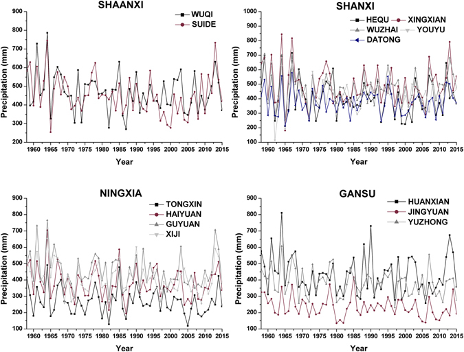
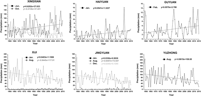
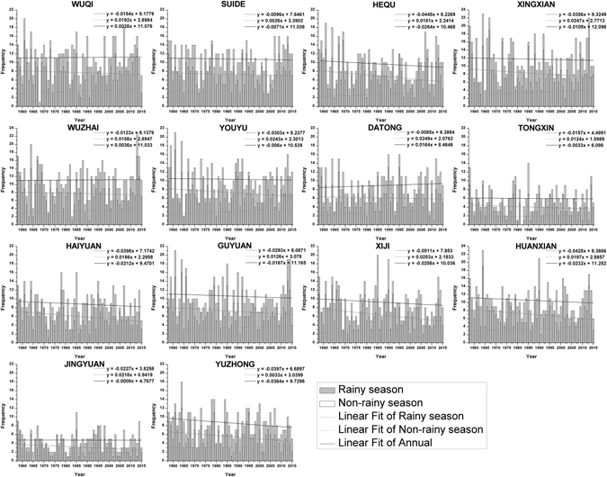
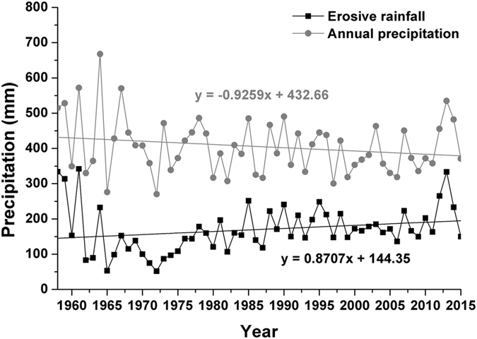
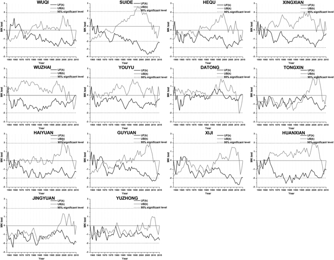
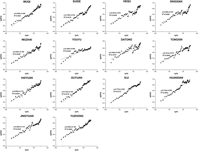
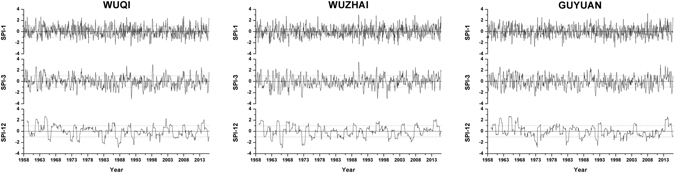
Precipitation plays an important and crucial role in processes in the water-wind erosion crisscross region of the Loess Plateau than in other parts of the region. We analyzed precipitation data and standardized precipitation index (SPI) at 14 representative synoptic stations from 1958 to 2015 used trend-free prewhitening, linear trend estimation, Spearman's rho test, the Mann-Kendall trend test, the Mann-Kendall abrupt change test and rescaled range analysis. The following conclusions were drawn. First, the analysis of monthly precipitation at all stations suggested that precipitation during the rainy season (July, August, September), especially rain in July and August, exhibited a general decreasing trend, while both increasing and decreasing trends were observed in other months. Moreover, the annual precipitation of all stations continued to exhibit decreasing trends except Wuzhai. Erosive rainfall frequency in the rainy season and the annual scale was weakly reduced but erosive force of single rainfall has been enhanced. Second, the SPI exhibited different increasing degrees in winter, while decreasing trends were observed in other seasons. Additionally, the annual-scale SPI at most stations exhibited a stable and sustained downward trend. Therefore, this region is currently associated with a drought trend, and the drought degree will likely continue to increase.

摘要

与黄土高原水蚀风蚀交错区的其他地区相比,降水在该区域的过程中发挥着重要且关键的作用。我们分析了1958年至2015年期间14个代表性气象站的降水数据和标准化降水指数(SPI),采用了无趋势预白化、线性趋势估计、斯皮尔曼秩相关检验、曼-肯德尔趋势检验、曼-肯德尔突变检验和重标极差分析。得出了以下结论。首先,对所有站点月降水量的分析表明,雨季(7月、8月、9月)的降水量,尤其是7月和8月的降雨,总体呈下降趋势,而其他月份则呈现出上升和下降两种趋势。此外,除五寨外,所有站点的年降水量持续呈下降趋势。雨季和年尺度上的侵蚀性降雨频率略有降低,但单次降雨的侵蚀力有所增强。其次,SPI在冬季呈现出不同程度的上升,而在其他季节则呈下降趋势。此外,大多数站点的年尺度SPI呈现出稳定且持续的下降趋势。因此,该地区目前正处于干旱趋势,干旱程度可能会继续加剧。

https://cdn.ncbi.nlm.nih.gov/pmc/blobs/0ba9/5556052/4bb1e70769dd/41598_2017_8600_Fig11_HTML.jpg
https://cdn.ncbi.nlm.nih.gov/pmc/blobs/0ba9/5556052/e594cfacb1f0/41598_2017_8600_Fig1_HTML.jpg
https://cdn.ncbi.nlm.nih.gov/pmc/blobs/0ba9/5556052/4148f2ef26a5/41598_2017_8600_Fig2_HTML.jpg
https://cdn.ncbi.nlm.nih.gov/pmc/blobs/0ba9/5556052/0a924d064d94/41598_2017_8600_Fig3_HTML.jpg
https://cdn.ncbi.nlm.nih.gov/pmc/blobs/0ba9/5556052/ee3f8c1f63f4/41598_2017_8600_Fig4_HTML.jpg
https://cdn.ncbi.nlm.nih.gov/pmc/blobs/0ba9/5556052/37042abf42d0/41598_2017_8600_Fig5_HTML.jpg
https://cdn.ncbi.nlm.nih.gov/pmc/blobs/0ba9/5556052/3aeb5dcaf46a/41598_2017_8600_Fig6_HTML.jpg
https://cdn.ncbi.nlm.nih.gov/pmc/blobs/0ba9/5556052/4284cfe7ddcd/41598_2017_8600_Fig7_HTML.jpg
https://cdn.ncbi.nlm.nih.gov/pmc/blobs/0ba9/5556052/8cbb23e3e5e3/41598_2017_8600_Fig8_HTML.jpg
https://cdn.ncbi.nlm.nih.gov/pmc/blobs/0ba9/5556052/c6ad5d2a8dda/41598_2017_8600_Fig9_HTML.jpg
https://cdn.ncbi.nlm.nih.gov/pmc/blobs/0ba9/5556052/26ec08634b69/41598_2017_8600_Fig10_HTML.jpg
https://cdn.ncbi.nlm.nih.gov/pmc/blobs/0ba9/5556052/4bb1e70769dd/41598_2017_8600_Fig11_HTML.jpg

相似文献

1
Change of precipitation characteristics in the water-wind erosion crisscross region on the Loess Plateau, China, from 1958 to 2015.1958 - 2015年中国黄土高原水蚀风蚀交错区降水特征变化
Sci Rep. 2017 Aug 14;7(1):8048. doi: 10.1038/s41598-017-08600-y.
2
Analysis of Precipitation Characteristics during 1957-2012 in the Semi-Arid Loess Plateau, China.中国半干旱黄土高原1957 - 2012年降水特征分析
PLoS One. 2015 Nov 3;10(11):e0141662. doi: 10.1371/journal.pone.0141662. eCollection 2015.
3
Climatic and drought characteristics in the loess hilly-gully region of China from 1957 to 2014.1957年至2014年中国黄土丘陵沟壑区的气候与干旱特征
PLoS One. 2017 Jun 8;12(6):e0178701. doi: 10.1371/journal.pone.0178701. eCollection 2017.
4
Variations of drought and its trend in the Loess Plateau from 1986 to 2019.黄土高原 1986 年至 2019 年干旱变化及其趋势。
Ying Yong Sheng Tai Xue Bao. 2021 Feb;32(2):649-660. doi: 10.13287/j.1001-9332.202102.012.
5
Spatiotemporal Rainfall Variability and Trend Analysis of Shimsha River Basin, India.印度希姆沙河流域时空降雨变化及趋势分析。
Environ Sci Pollut Res Int. 2023 Oct;30(49):107084-107103. doi: 10.1007/s11356-023-25720-3. Epub 2023 Feb 11.
6
Spatial and statistical trend characteristics of rainfall erosivity (R) in upper catchment of Baram River, Borneo.沙捞越巴兰河上游降雨侵蚀力(R)的时空分布特征及其统计趋势。
Environ Monit Assess. 2019 Jul 13;191(8):494. doi: 10.1007/s10661-019-7604-z.
7
[Sediment-yielding process and its mechanisms of slope erosion in wind-water erosion crisscross region of Loess Plateau, Northwest China].[中国西北黄土高原风水蚀交错区坡面侵蚀产沙过程及其机制]
Ying Yong Sheng Tai Xue Bao. 2012 Dec;23(12):3281-7.
8
Evidences of climate change presences in the wettest parts of southwest Ethiopia.气候变化在埃塞俄比亚西南部最湿润地区存在的证据。
Heliyon. 2021 Sep 17;7(9):e08009. doi: 10.1016/j.heliyon.2021.e08009. eCollection 2021 Sep.
9
Rainfall trend and variability in Southeast Florida: Implications for freshwater availability in the Everglades.东南佛罗里达州的降雨趋势和变化:对大沼泽地淡水供应的影响。
PLoS One. 2019 Feb 12;14(2):e0212008. doi: 10.1371/journal.pone.0212008. eCollection 2019.
10
Investigating variations of precipitation concentration in the transitional zone between Qinling Mountains and Loess Plateau in China: Implications for regional impacts of AO and WPSH.研究中国秦岭与黄土高原过渡带降水集中程度的变化:对 AO 和 WPSH 区域影响的启示。
PLoS One. 2020 Nov 5;15(11):e0238709. doi: 10.1371/journal.pone.0238709. eCollection 2020.

引用本文的文献

1
Global assessment of storm disaster-prone areas.全球风暴灾害易灾区评估。
PLoS One. 2022 Aug 24;17(8):e0272161. doi: 10.1371/journal.pone.0272161. eCollection 2022.
2
Drought characteristics and its elevation dependence in the Qinghai-Tibet plateau during the last half-century.过去半个世纪青藏高原干旱特征及其与海拔的关系。
Sci Rep. 2020 Aug 31;10(1):14323. doi: 10.1038/s41598-020-71295-1.
3
Evaporation abrupt changes in the Qinghai-Tibet Plateau during the last half-century.青藏高原近半个世纪来的蒸发突变。

本文引用的文献

1
Spatial and temporal evolution of climatic factors and its impacts on potential evapotranspiration in Loess Plateau of Northern Shaanxi, China.中国陕北黄土高原气候因子的时空演变及其对潜在蒸散量的影响。
Sci Total Environ. 2017 Jul 1;589:165-172. doi: 10.1016/j.scitotenv.2017.02.122. Epub 2017 Mar 1.
2
Decreasing trend in severe weather occurrence over China during the past 50 years.过去 50 年来中国极端天气发生频次呈下降趋势。
Sci Rep. 2017 Feb 17;7:42310. doi: 10.1038/srep42310.
3
Analysis of Precipitation Characteristics during 1957-2012 in the Semi-Arid Loess Plateau, China.
Sci Rep. 2019 Dec 27;9(1):20181. doi: 10.1038/s41598-019-56464-1.
4
A new method to evaluate floodwater for control/use in high-sediment rivers of Northwest China.一种评估中国西北高含沙河流中用于控制/利用的洪水的新方法。
Sci Rep. 2017 Dec 8;7(1):17219. doi: 10.1038/s41598-017-17489-6.
中国半干旱黄土高原1957 - 2012年降水特征分析
PLoS One. 2015 Nov 3;10(11):e0141662. doi: 10.1371/journal.pone.0141662. eCollection 2015.
4
Climate extremes: observations, modeling, and impacts.极端气候:观测、建模与影响
Science. 2000 Sep 22;289(5487):2068-74. doi: 10.1126/science.289.5487.2068.